Next storm in Massachusetts will have heavy rain and floods washing away snow
BOSTON - Winter has officially arrived in Massachusetts! More than a foot of snow fell in parts of the Merrimack Valley and Worcester County. Closer to the coast, they had to wait until the end of the storm before piling up several inches just before the final bell.
I think it is safe to say, we could all use a breather, a nice quiet week to clean up our driveways and roads and gradually melt some of the fresh, giant snow piles.
Unfortunately, that's not happening.
When is the next storm coming to Massachusetts?
In fact, Sunday was just the first in what looks like a conga line of powerful storms about to cross the country and blow through New England. It is very likely that we will have to deal with two major storms this week, Wednesday and Saturday, and the parade could very well continue into the following week.
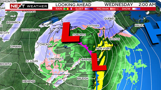
The next few storms will take a much different track and therefore, come with a different variety of impacts. Sunday's storm came from the deep south, riding up the East Coast and just south of New England. That is a pretty classic recipe for snow here in southern New England.
Now, the storm track shifts much farther west, the low-pressure centers will pass through the Upper Midwest. With a track such as this, the heaviest snow will fall from the northern Plains through the Great Lakes Region.
Great news, right? Finally, the snow "bullseye" won't be in our backyard? Be careful what you wish for.
For now, let's focus on what's coming next.
Snow for some, rain for others Tuesday
Our next storm will arrive Tuesday evening. It will start as a quick thump of snow in the elevated areas of Worcester County and up in central and northern New England. There could be several inches of heavy, wet snow in those areas Tuesday night.
For the rest of southern New England, this storm will be wet, not white.
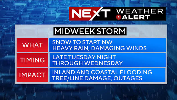
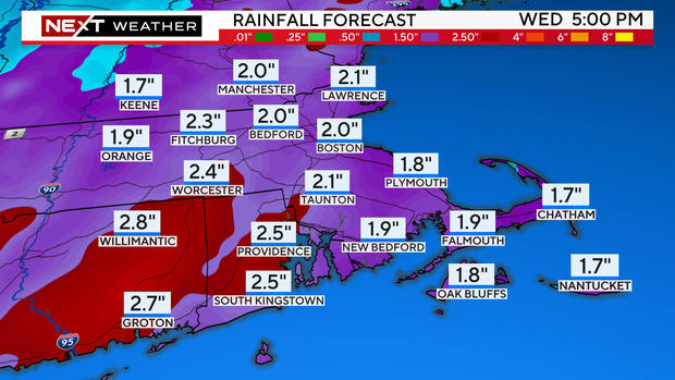
The problem is the sheer amount of water that is coming. There will be periods of very heavy rain (downpours) late Tuesday night through early Wednesday. Between 10 p.m. Tuesday and 10 a.m. Wednesday, our entire area could receive 1-to-3 inches of rainfall.
Combine that with near-record warm temperatures (well into the 50s) and you have a recipe for a very rapid and dangerous snowmelt. River, road and basement flooding are almost a certainty.
Just as concerning, the winds. There is a risk of gusts as high as 50-to-70 mph across portions of eastern Mass., particularly over far southeastern Mass., Cape Cod and the Islands.
Sunday's storm brought northeast winds. Wednesday's winds will come out of the south and will be roaring all night. Widespread tree and power line damage is almost certain as are numerous power outages.
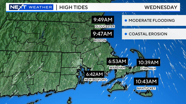
Another difference between Sunday's storm and the midweek storm - coastal flooding.
The tides will be much higher (astronomically speaking) when the next storm arrives.
There is a real risk of at least moderate coastal flooding early Wednesday morning along the south facing beaches in Narragansett and Buzzards Bay as well as the entire South Coast of Massachusetts.
We will have much more on this storm in the next 24 hours. Needless to say, it is imperative that we do a rapid cleanup on Monday and Tuesday. Clear all the storm drains and prepare as best we can for a lot of water.
The WBZ NEXT Weather Team will continue to provide frequent updates on WBZ-TV, WBZ.com and streaming on CBS News Boston.


