Earthquake "shake map" shows where Maine quake was felt
BOSTON - An earthquake just off the Maine coastline on Monday could be felt in Boston and hundreds of miles away into Connecticut and Vermont, according to a "shake map" from the United States Geological Survey.
The map shows the majority of reports were concentrated on the North Shore of Massachusetts, southeastern New Hampshire and southern Maine, where the epicenter of the 3.8 magnitude earthquake occurred about six miles off York Harbor at 10:22 a.m.
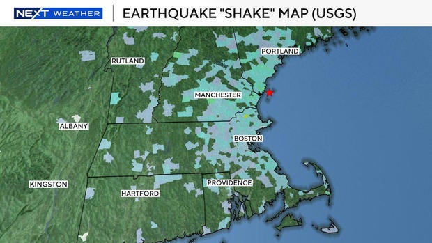
There even appeared to be some rumbles felt in eastern New York state around Albany, the map showed.
The USGS collects "Did You Feel It?" reports from the public after an earthquake. As of Monday afternoon, about 35,000 people had shared what they felt with the agency.
Earthquake in Boston
An earthquake of this size happens about once every four or five years in the region, Boston College geophysics professor John Ebel at the Weston Observatory told WBZ-TV.
It was felt by some in Boston and surrounding communities.
"Yes, that was an earthquake we just felt," police in Wellesley posted to Facebook. "The Wellesley Police station certainly shook a little."
Some who felt the shaking didn't know what was happening at first.
"I thought it was a large truck going down the road," a WBZ-TV viewer from South Dennis commented on social media. "The windows shook."
Earthquake video from Maine
A live camera from the Nubble Lighthouse in York, Maine, not far from the earthquake's epicenter, showed brief shaking on Monday morning.
Those who lived closest to the earthquake said it was a scary event.
"I'm still shaking," one woman commented on the York Beach Fire/Rescue Facebook page. "Felt like it was under my house. I'm about 3 miles from the harbor."
A Kittery resident described the earthquake as "huge and loud."
"House and cabinets shook," she commented in response to a York Fire Department Facebook post. "We thought a plane crashed nearby."


