EF-1 tornado touched down in Howard County, NWS confirms
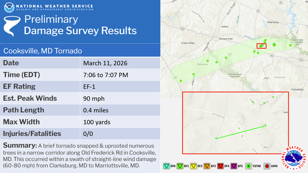
An EF-1 tornado touched down in Howard County on Wednesday, March 11, as parts of Maryland experienced severe weather and storms, the National Weather Service (NWS) confirmed.
After conducting a storm survey, the agency determined that the tornado briefly touched down in Cooksville between 7:06 p.m. and 7:07 p.m. During that time, maximum winds were estimated at 90 mph. The tornado was about 100 yards wide wth a path of about .4 miles, NWS said.
Storms in Maryland
Parts of Maryland experienced strong storms and gusty winds on Wednesday after a cold front arrived, following days of record-high temperatures.
In Frederick and Carroll Counties, the National Weather Service determined there was straight-line wind damage of up to 60 to 75 mph, with some areas like Woodsboro reaching 90 mph.
Storms moved through Baltimore City on Wednesday evening after the city experienced a record high of 85 degrees.
Following the stormy weather, temperatures across the state dropped into the low to mid-30s by midday Thursday.
Spring-like temperatures to snow
On Thursday, after the storms, Maryland experienced a small amount of snow accumulation, and the weather whiplash shocked residents.
"You could ride around in Maryland and probably find four different weather patterns," said Darryl Payne with the LRW Traffic Control System. "The weather gonna be, what weather gonna be."
Payne and his crew were out assisting Baltimore Gas and Electric (BGE) with removing downed trees and restoring power on Thursday after the storm.
"I'll be glad when spring actually springs, because this is cold, I'm done with it," Payne said.