Sunshine with cooler temperatures take over Maryland today
Sunshine will return through the afternoon today with afternoon temperatures holding in the 50s as cooler weather will set the stage for the first frost for many areas of Maryland during the overnight hours.
Drier weather moves in for the rest of the weekend
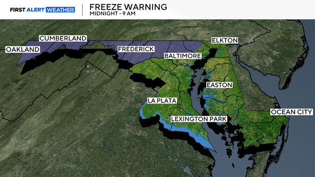
Saturday evening will see colder air moving in with some northern and western areas of Maryland dropping down to near freezing by daybreak Sunday. A Freeze Warning is in effect from 1 am until 8 am Sunday morning for northern Harford and Baltimore Counties and counties westward to the West Virginia state line - excluding Howard and Montgomery Counties where a Frost Advisory is in effect. Overnight temperatures will range from the mid to upper 20s across the mountain regions to the mid to upper 30s in Southern and Eastern Maryland.
Gorgeous day ahead for Sunday across Maryland
After a frosty start - sunny skies skies will help to warm temperatures back up to near 60 by Sunday afternoon with more seasonable temperatures moving in for the beginning of the work week. Highs each day will reach into the mid to upper 60s with overnight lows in the 40s to low 50s.
Potential offshore storm might impact Maryland next week
The First Alert Weather team will be monitoring a potential coastal storm indicated by some weather models forming off the coast of the Carolinas early in the work week. If this system develops, some clouds and showers could move into Eastern areas of Maryland and this system could linger offshore for a few days. Check back with WJZ as the work week approaches for updates on this system.