Frigid Temps Set The Stage For Snow, Wintry Mix
BALTIMORE (WJZ) -- Maryland will be seeing a variety of winter weather over the next two days.
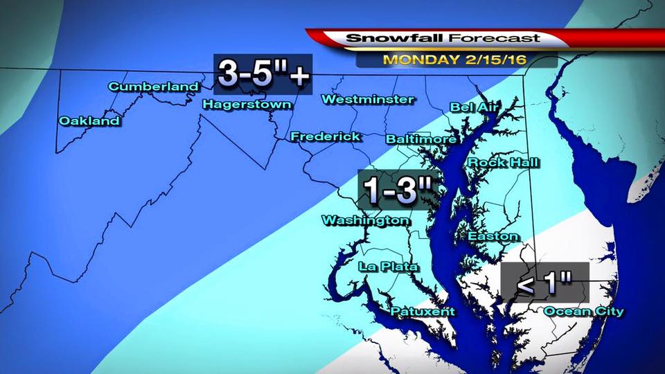
"An arctic high retreats off to the east tonight and clouds will lower and thicken as warm air approaches," says Meteorologist Chelsea Ingram. "As the warm, moist air overruns the cold air in place at the surface, light snow will break out early Monday morning. The morning commute can certainly be slick with a fresh coating to 1" of snow in place. The snow will continue, light to moderate through midday tomorrow. We should total a fresh 1-3" of snowfall in the Baltimore area."
A Winter Weather Advisory is in effect for: Garrett; Cecil; Calvert; St. Marys; Carroll; Northern Baltimore; Northwest Harford; Southeast Harford; Southern Baltimore; Anne Arundel; Central and Southeast Howard; Charles; Prince George; Central and Southeast Montgomery; Northwest Howard; Northwest Montgomery.
A Winter Storm Warning is in effect for: Central and Eastern Allegany; Extreme Western Allegany; Frederick; Washington

Snow will begin to accumulate early Monday for parts of the area.
Snow and sleet accumulation of one to three inches is possible.
Temperatures will continue to skyrocket in the warm sector on Tuesday, with upper 40s and 50s expected.
WATCH: Latest First Warning Weather Forecast:
Track weather using our CBSBaltimore Weather App!
Latest school closings and delays: CLICK HERE.