Heat wave begins in Maryland, peaking Wednesday and Thursday
The First Alert Weather Team has issued Alert Days for extreme heat this Wednesday and Thursday as temperatures will top out near or above 100°.
Wednesday through Friday will feature the hottest high temperatures but afternoon highs could drop below heat advisory levels as we head into the weekend as rain and storms chances increase.
While this upcoming heat wave will be tough, it will not be as brutal as the one during the 4th of July holiday weekend, as humidity levels will not be nearly as high.
Heat wave starts Tuesday across Baltimore
Maryland's next heat wave will begin in many areas Tuesday as high temperatures climb into the lower to middle 90s. The heat on Tuesday is very seasonable for Maryland during the summer months and an added bonus will be low to moderate humidity levels. This means that the feels-like temperature should match the forecast highs in most neighborhoods.
The heat wave peaks on Wednesday and Thursday.
High temperatures will climb to around 100° both afternoons. Once again, humidity levels don't look sweltering, which will make a big difference in the feel of the heat wave. Heat index values should top out between 100° to 105°.
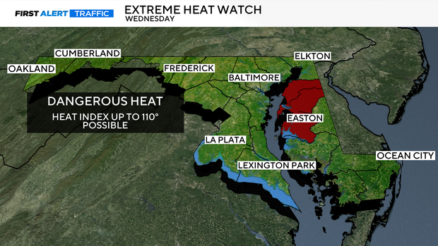
An Extreme Heat Watch has been issued for three Eastern Shore counties for Wednesday: Kent, Queen Anne's and Talbot. Caroline County is under a Heat Advisory.
Friday will be our last day of tough heat with highs in the middle to upper 90s. There's an outside chance of a few isolated afternoon and evening storms, but the better chance for storms will come during the afternoon and evening this weekend.
Weekend starts steamy, gusty storms possible
The weekend high temperatures aren't forecast to be nearly as high as mid to late this week.
High temperatures will top out in the lower 90s, but higher humidity levels may make it feel rather uncomfortable. Heat index values on Saturday may reach 95° to 101° before any afternoon storms form. Relief will come with temperatures back in the 80s by early next week.
The First Alert Weather Team is keeping an eye on the threat and will pass along updates throughout the week.