Dangerous cold, hard freeze warning headed for North Texas

NORTH TEXAS - Arctic air arrived Saturday afternoon and we are expecting freezing rain/sleet Sunday night into Monday morning. Travel issues are almost certain.
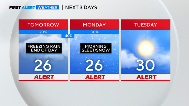
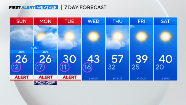
The next three days have Weather Alerts in place to warn you of dangerous cold and ice on the roads.
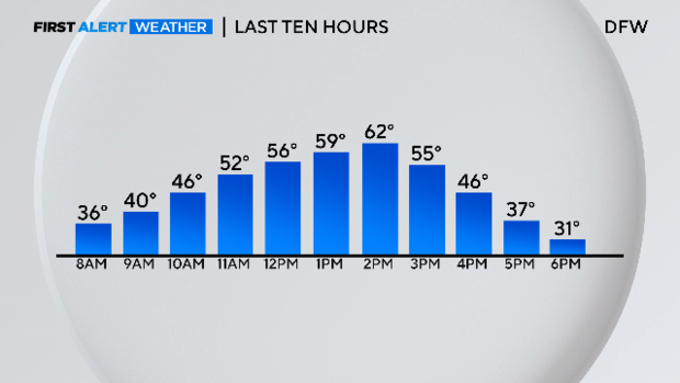
Despite the freezing start at DFW Saturday morning, temperatures climbed into the low 60s. Then they plummeted in the afternoon. We got below freezing around 6 p.m. We'll stay below freezing for the next 85 hours or so, until Wednesday late morning.
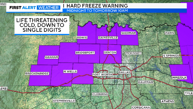
Temperatures will drop to the single digits in some places. A hard freeze is in effect for a dangerous cold Saturday night.
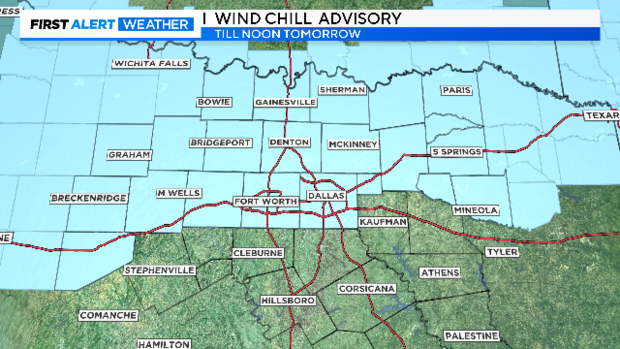
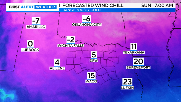
Wind chills by Sunday morning will be in the single digits. Wind chill advisories are posted until noon Sunday for the first time this season for the metroplex.
This is dangerous cold. Please avoid prolonged exposure to this chill and dress so there is little or no exposed skin if outside late Saturday night or across Sunday morning.
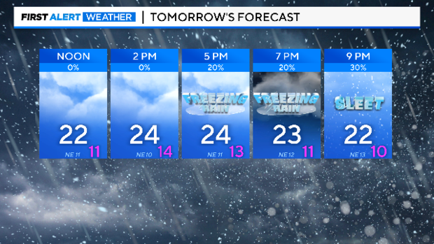
As worried as we are about the extreme cold, there is even greater concern about the potential of ice. Light freezing drizzle will start to show up Sunday afternoon. It should turn into freezing rain/sleet by evening and overnight. There will be enough to stick immediately to the roads. Highs Sunday are only in the mid-20s.
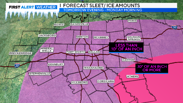
Please try to stay off the roads starting Sunday night and all the way into mid-day Monday. This will be when the roads are most dangerous, especially the bridges and overpasses. The ice won't be everywhere but you could be driving and suddenly hit a large area of it. It'll be a holiday and I hope most can and will take this advice. It's okay to miss a day of commerce on the rare occasion.
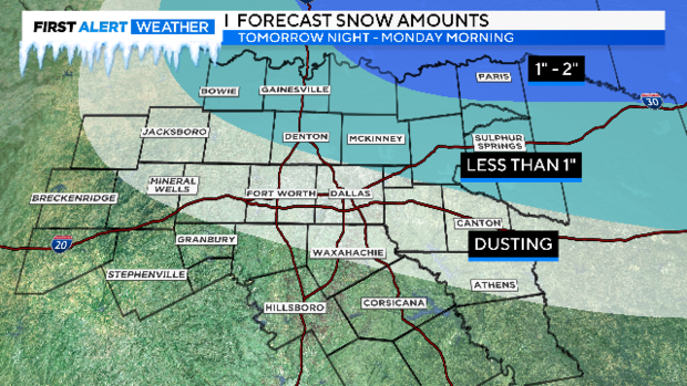
If you are hoping for snow, most of North Texas sees very little. The best chance for accumulating snow is confined to the northeast along the Red River.
Oh, the cold. Look at Sunday. DFW hasn't even had a day where it stayed in the 30s all day. Suddenly we are staying in the 20s. I hope you spent today preparing for this cold, covering your outdoor faucets and getting your plants inside or covered. All pets inside please and check on the elderly!
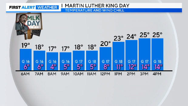
Check out the temperatures on Monday, Martin Luther King Jr. Day. I hope everyone can stay indoors!
The coldest morning looks to be Tuesday. Wind chills will be in the negative numbers at the bus stop. Bundle those kids up!
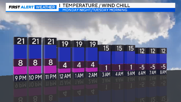
The worst of the travel problems will be Sunday night and Monday morning. Patchy ice will still be on the roads Monday night and Tuesday morning. We'll finally get above freezing by mid-morning on Wednesday. We are still forecasting below-normal temperatures for the rest of the month.
The Weather Alert team will be in the CBS News Texas Weather Center around the clock over the next several days. This is a dangerous cold with dangerous ice. Please keep checking in for forecast updates.


