Edouard weakens to tropical depression as heavy rain continues over southeastern Texas
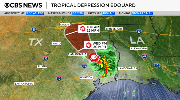
The former Tropical Storm Edouard, which has weakened to a tropical depression, continued to bring wind and heavy rain to Texas Wednesday as the system moved inland. The National Hurricane Center said up to another 8 inches of rain — or even more in some areas — was expected to fall before Edouard dissipates Wednesday night.
Edouard had maximum sustained winds of 35 mph Wednesday morning, decreasing from about 60 mph when it made landfall near Johnson Bayou, Louisiana, close to the border with Texas, on Tuesday afternoon, the hurricane center said.
Maps show storm's path and forecast
Flood watches remained in effect Wednesday morning for portions of eastern Texas and its Gulf Coast. A tropical storm warning that had been issued for a stretch of southeastern Texas and southwestern Louisiana has been discontinued.
The depression was moving toward the northwest at about 5 mph on Wednesday morning, on a trajectory that forecasters said would likely persist for the next day or so as it travels inland over southeastern and eastern Texas.
Strong thunderstorms were expected to bring powerful wind gusts and dump heavy rain, with 4 to 8 inches possible along the Texas coast and inland. Some areas could get up to 12 inches.
Another 2 to 4 inches of rain could fall in parts of southwestern Louisiana.
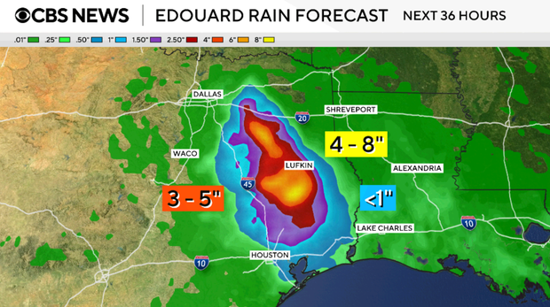
The hurricane center warned that "significant flash flooding," as well as river flooding, was possible as a result of the rain, "especially in low-lying and urban areas."
Texas, Louisiana residents ride out the storm
As Edouard stormed ashore along the Texas-Louisiana border, many residents decided to stay put and ride out the storm, but some chose to seek shelter elsewhere.
"You can't stay in a travel trailer, an RV, because the wind gusts can knock you over," Karen Cauthen, a Port Arthur, Texas, resident, told CBS News. "It doesn't make sense to me."
Edouard's winds also whipped at homes in Holly Beach, Louisiana, an area that has taken a beating from several tropical storms over the last few years.
Edouard is the fifth tropical storm so far during the 2026 Atlantic hurricane season.