Since Loma Prieta, Bay Area earthquake sensor network has expanded nearly fivefold

SAN FRANCISCO -- Tuesday marks 33 years since the Loma Prieta earthquake. For many who were around when the 6.9 magnitude earthquake hit, they remember where they were and exactly what they were doing. Scientists can also look back and see how earthquake monitoring has changed since 1989.
U.S. Geological Survey seismologist Dr. Annemarie Baltay said the Loma Prieta earthquake showed us how places far away from the epicenter could still suffer severe damage, especially in landfill or unstable soil. The city's Marina District is one such area that received significant damage from liquefaction.
"The Marina sits on very soft, landfill," said Baltay. "If you take a bowl of jello, and you shake that, it kind of starts shaking, amplifies and it lasts a lot longer. It's very similar to what happened in the Marina."
"The entire community was affected here for sure," said Paul Bosco, whose family owns Lucca Delicatessen in the Marina, which escaped major damage. "The difference between this building and other buildings in the Marina is that it's not a corner building. It's in the middle of the block and as you can see, this building is butted up with this building here. So when the earthquake happened, basically the buildings just kind of bounced off of each other and held each other up."
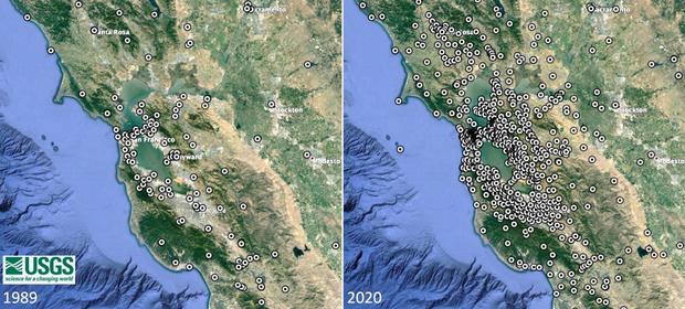
Scientists can remember the scarcity of earthquake monitoring stations compared to how many there are today.
"Since 1989 Loma Prieta, we've actually put in about five times as many stations like this one here," said Baltay. "So the USGS is constantly working to be able to more quickly identify and locate earthquakes and be able to tell you where they're happening."
The USGS has added more seismic sensors across the Bay Area providing valuable, continuous, real-time data. There were just around 120 seismic sensor stations in 1989 and now, there are 550 seismic sensor stations.
"As earthquakes occur, the waves travel here and are recorded at this station at Coyote Point," said Baltay. "The information is then immediately sent to our computers. We can quickly determine where and when an earthquake occurred and use that information for our earthquake early warning network."
"This is actually the seismic instrument, so inside this box, there are instruments that record the earthquake as it comes to this station," continued Baltay. "Then this box is connected here to the power system, which is powered by the solar panel and above that is a GPS antenna and a radio, so the information can quickly be sent out to our networks and our computers."
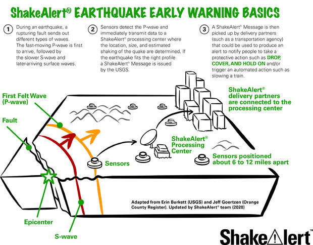
When USGS seismic sensors detect an earthquake of magnitude 4.5 or higher, a ShakeAlert Earthquake Early Warning message will be sent to local transportation agencies like BART and also to you if your phone is in the region. The warning is only a matter of seconds.
That's why the USGS recommends having an earthquake plan for you and your family including an earthquake preparedness kit.


