Rain chances increasing throughout the day for the Pittsburgh area

PITTSBURGH (KDKA) -- There's another severe weather chance today.
Any Alert Days Ahead? Today is a First Alert Weather Day with severe weather possible. Rain totals today may hit an inch.
Aware: Some places (higher elevations, north of I-80) could see frost over the weekend.
Technically, there are two distinct periods where severe weather will be possible. The first chance for severe weather likely occurs from 9 a.m. to noon.
A line of showers will slowly track north with severe weather being possible from the city of Butler to the south. Large hail is the biggest concern this morning.
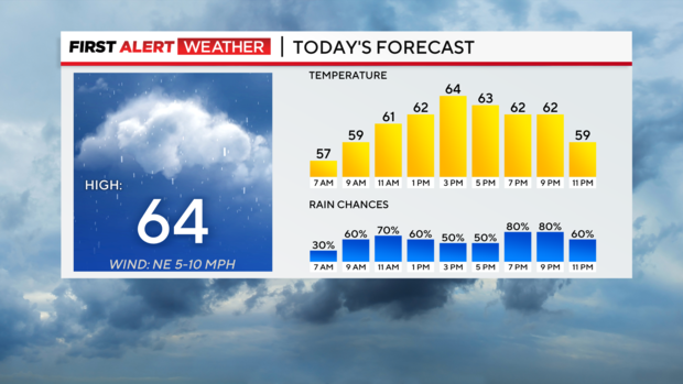
Downpours and frequent lightning will also be possible. Morning temperatures will hover in the mid to low 50s for most but temperatures hovering near 50 for places along I-80.The afternoon hours will continue to see rain chances increasing.
From noon to 5 pm. we should see scattered rain with some fairly long stretches of dry time. Fast-moving storms should develop to our west after 5 p.m. and will quickly roll through during the afternoon hours.
Wind speeds above 60mph will be possible with some of these storms, bringing our second chance of severe weather today. The further south you are today, the higher the chance for severe weather.
Cooler weather will be around for the weekend with highs near 60 expected both on Friday and Saturday.
Morning lows will be down in the 40s.
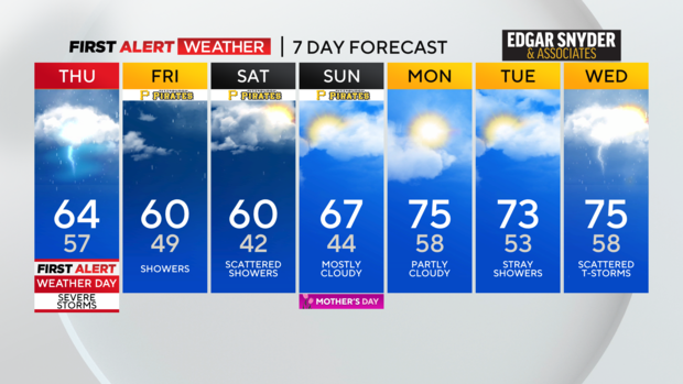
Pesky showers will stick around for both days with an odd storm chance possibly being there on Saturday as the core of an upper low rolls by.
WEATHER LINKS:
Current Conditions | School Closings & Delays | Submit Your Weather Photos


