Pittsburgh Weather: First Alert Weather Day issued for Tuesday

PITTSBURGH (KDKA) -- The Fourth of July is beautiful, but Tuesday is a First Alert Weather Day because of a chance for storms.
AWARE: Showers in the morning, then stronger storms possible after sunset Tuesday
It was a hot holiday, but it was dry and sunny. The rest of the evening will be dry for the fireworks with temperatures around 80 degrees.
Overnight, clouds will increase, leading up to some showers developing by the morning, and lows falling down to the mid-60s. Widespread rain with a small chance for general thunderstorms is expected for the morning commute.
The afternoon will dry out for a short time, but it'll be very hot and muggy. The next round of rain arrives around sunset, but this round will feature the best chance for severe weather. Any pop-up storms could have damaging winds, hail, heavy rainfall and/or an isolated tornado. Those are the main threats to watch out for.
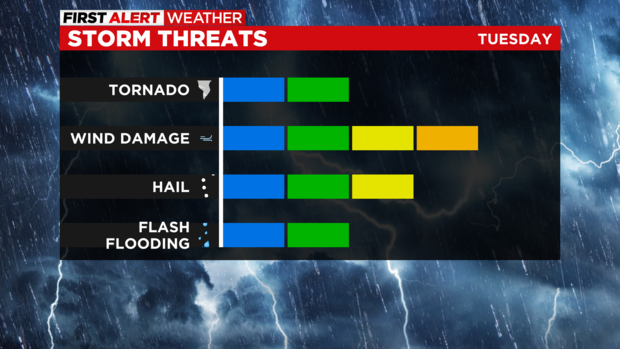
More widespread rain will last through Wednesday morning, and the threat for flash flooding could occur. Just remember: do not drive through a flooded roadway. Turn around, don't drown.
The rain will continue through at least Friday. Each day will feature more scattered showers and/or storms. It will also be very muggy and sticky with high dewpoints each day and highs in the mid-80s. Each morning you'll wake up around 70 degrees and high humidity.
Relief arrives by the weekend with lower humidity levels, and highs will be in the low 80s with sunshine!
WEATHER LINKS: Current Conditions | School Closings & Delays | Submit Your Weather Photos


