Pittsburgh Weather: Morning snow showers make way for cloudy skies

PITTSBURGH (KDKA) — The best chance for snow is happening this morning and will last through Noon today.
Daily average High: 36 Low: 21
Sunrise: 7:38 Sunset: 5:28
WEATHER LINKS:
Current Conditions | School Closings & Delays | Submit Your Weather Photos
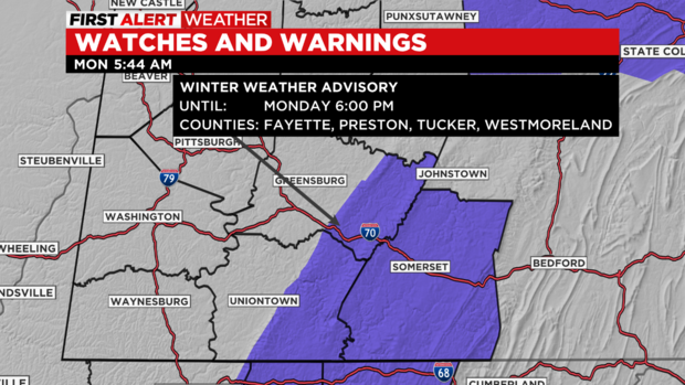
Today: There is a winter weather advisory for the Ridges of Fayette and Westmoreland counties through 6 p.m.. Best chance for snow occurs before noon for most areas.
Any Alert Days Ahead? Wednesday morning looks pretty nasty right now. I am going to continue to look through the data and go back through what weekend shifts had and then will make a decision on the day.
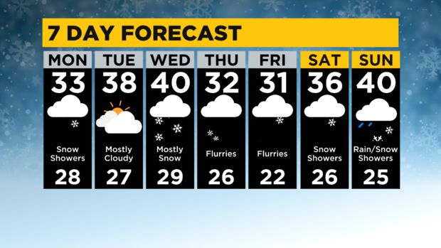
Aware: Winter is here with at least a chance of something falling from the sky on every day of the 7 day. Best chance is Wednesday with lowest chance coming on Tuesday with just an isolated flurry chance.
There is plenty to talk about when it comes to snow over the next couple of days. There was a band of snow that dropped decent snow totals to the area yesterday afternoon into the evening.
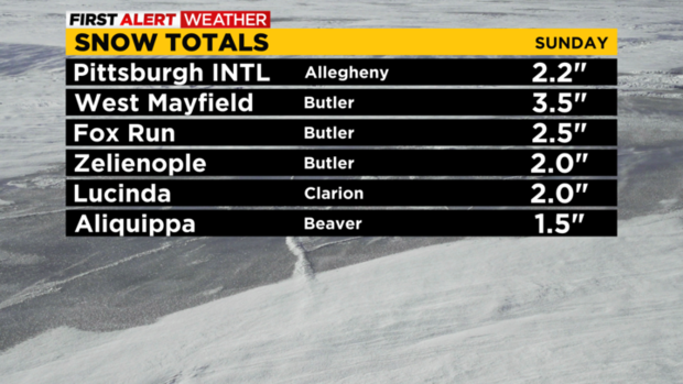
At this point, snow reports are all about 8 hours old. Through 4 a.m., the latest totals are below:
- West Mayfield: 3.5" (Butler Co.)
- Fox Run: 2.5" (Butler Co.)
- Zelienople 2.0" (Butler Co.)
- Lucinda 2.0" (Clarion Co.)
- Aliquippa 1.5" (Beaver Co.)
- Wexford 1.2" (Allegheny Co.)
The best chance for snow is happening right now and will last through noon today. The Ridges of Fayette and Westmoreland County are under winter weather advisories until 6 p.m. tonight. 2"-4" of snow is expected to fall through then in these areas.
Road conditions seem to be in pretty good shape this morning as the slow drop in temperatures overnight enabled road crews to get out and jump on salting roads. Road temperatures are still warm for this time of the year too. I only have highs hitting around 33 degrees today. That is a couple of degrees lower than what model data indicated for today.
I have lows being hit just before midnight at around 28 degrees. Morning lows should be a degree or two warmer than that. Skies will be cloudy through the day with winds coming in out of the northwest at 7-15mph.
Looking ahead, Wednesday looks like a big mess for the morning commute with what could be a couple of quick inches of snow falling along a warm front.
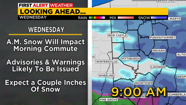
It will be one of those days where we see some decent snow totals and then all of a sudden the snow is completely gone by 5 p.m..
Winter storm watches (plus 6" of snow) may be needed for Wednesday morning.
Stay up to date with the KDKA Mobile App – which you can download here!


