Pittsburgh Weather: Kicking off a cool, dry week

PITTSBURGH (KDKA) -- It's looking like a slow week with us potentially dry all the way through the weekend.
Today: Frost advisories north of I-80. Dry and seasonal.
Any Alert Days Ahead? There may not even be any rain over the next week.
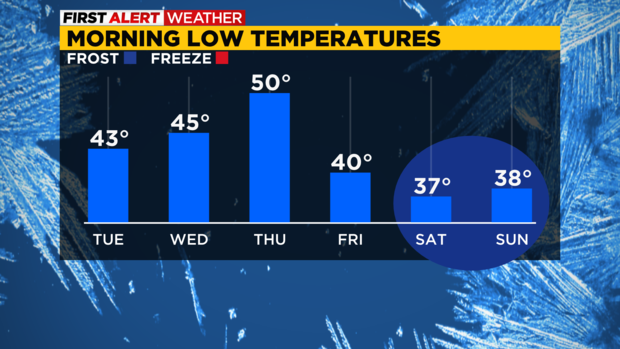
Aware: Coolest air of the season yet arrives this weekend with a couple of days with highs struggling to get back up to the 50's.
WEATHER LINKS:
Current Conditions | School Closings & Delays | Submit Your Weather Photos
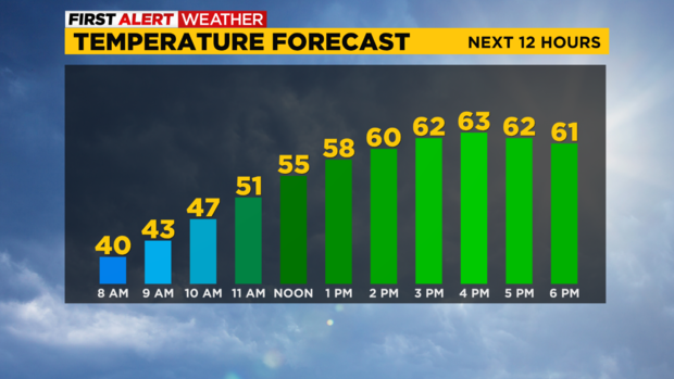
Temperatures are recovering back into the lower- to mid-60s today and Tuesday, and we'll make a run at 70 degrees mid-week. We'll stay dry most of the week with our only chance of any showers possibly sneaking in on Thursday night into Friday with a pretty strong cold front.
We will have clouds building but could stay dry as much cooler air invades dropping our high temperatures from 70 Thursday to only the mid-50s by Friday and Saturday.
Lows next weekend will dip into the 30s, so that will mark our first chance of widespread frost -- right on cue as our average first frost in Western Pennsylvania falls between Oct. 1-15. Leaves are starting to show some color in spots with this week's sunshine, daytime warmth and clear, cool, nights sure to aid in bringing out some more fall foliage change next week.
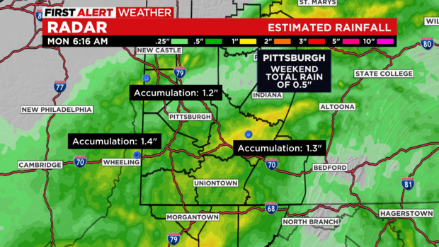
All that talk about post-tropical Ian and Pittsburgh got just 1/2" of rain. To be honest, it seemed like a lot more than that as the rain kept coming on Saturday and Sunday. The highest totals according to radar estimates fell in Westmoreland County with the highest totals in a line from just south of Greensburg through West Wheatfield over to Vintondale. These communities saw around an inch and a half of rain. We also saw some isolated 1.5" estimated totals near Ellwood City in southern Lawrence County extending across I-79 to around Muddy Creek. Besides those outliers, rain totals slightly increased the further south you go.
The remnants of Ian are still churning along the east coast and bringing fairly heavy rain to places like Philadelphia and New York City this morning. If traveling to these communities expected it to be a wet one as this storm continues to slowly move north.
It is in no hurry to move on with model data showing these communities still getting rain as late as Thursday from it.
Along with rain, gusty winds and coastal flooding should be expected. Flooding will peak during high tides.
Stay up to date with the KDKA Mobile App – which you can download here!


