Pittsburgh Weather: Freeze watches in place, possible snow on the way

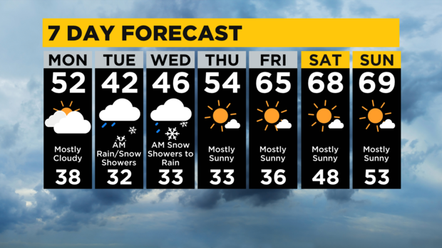
PITTSBURGH (KDKA) -- We are expecting our first measurable snow of the year to occur on Tuesday night into Wednesday morning.
Today: An isolated shower, cloudy with temperatures below average.
Any Alert Days Ahead? Yes. I have not issued it yet but a freeze warning could bring a First Alert for Tuesday. Also, snow chances, while having small impact, one could make the argument about it being a First Alert too.
Aware: Watching the 'blink and you'll miss it' accumulating snow chance for our area. Larger impact for places north of I-80 where lake effect may mean more than 5" of snow in some spots. Near 10" possible up in Erie area.
This may be a good time to discuss the difference in accumulating, measurable, and trace snow.
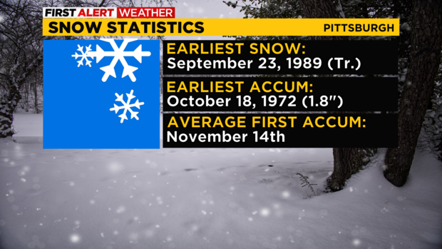
Accumulating has the biggest impact on the area and means snow that is piling up on grassy areas or in the worst cases is accumulating on roads. This upcoming snow event will have the chance to see some accumulations on grassy areas. If you are south of I-80 the chance of seeing any snow accumulating on roads on Tuesday night to Wednesday is extremely low. All snow on hard ground should melt quickly before accumulating.
Measurable snow is what you'll see when it comes to the official snow total coming in from the National Weather Service. It comes as 'daily snowfall.' Sometimes this snow accumulates, and sometimes it does not. It is basically what machines measure falling from the sky. The differences can be pretty big on some days and spot on others.
Finally, a trace or unmeasurable amount of snow means just that. Machines registered some snow but it was so tiny it didn't hit the threshold for being measured. For snow, this means less than a tenth of an inch.
If you're wondering about the amount of snow to expect for Tuesday into Wednesday, I am working on snow maps now. The impact on motorist will be minimal is the best news I can give and all snow south of I-80 (if we see any accumulation at all) will be gone by Wednesday afternoon.
The other big story for Today through Thursday morning are temps seeing their first big dip of the season.
There are currently freeze watches issued across our area and at some point the freeze watches will become warnings for a number of communities. Looking at temperatures this morning from model data, there is a solid chance some watches are just dropped with most communities in some counties expected to remain above 32°.
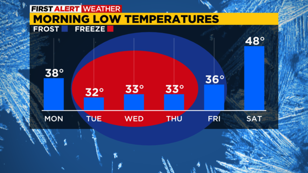
The chill will be felt from Tuesday morning through Thursday morning with a number of places falling below 32.
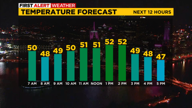
Finally back to today's weather. This is an isolated rain chance today with overcast skies expected. Highs will be in the low 50s with morning lows dipping to the 30s for most places. Enjoy!
WEATHER LINKS:
Current Conditions | School Closings & Delays | Submit Your Weather Photos


