Pittsburgh Weather: Drizzle, light rain, and snow possible; impact to drivers minimal

PITTSBURGH (KDKA) - While Tuesday night snow should be just a minor inconvenience for some, a couple of inches of snow will be possible for some parts of the Laurels.
WEATHER LINKS:
Current Conditions | School Closings & Delays | Submit Your Weather Photos
We could be dealing with a decent snow event happening on Tuesday night into Wednesday morning. Right now, model data is all over the place when it comes to handling the mid-level low. I have the low moving right on top of us tomorrow afternoon, exiting our area by 5 a.m. on Wednesday.
Most of the time for these systems, the heaviest snow comes around 50 miles to the north of the center of rotation. That would put places along I-80 as the biggest area of concern. Model data though is showing a system moisture starved and ill-defined currently with the heaviest snow occurring along the I-70 corridor.
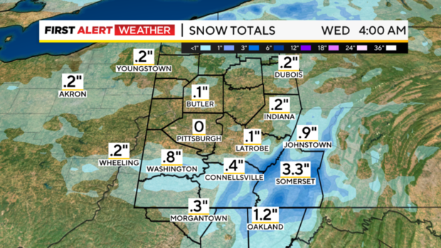
Data also jumps on the Laurel Highlands for some big snow totals as well. It will be cold enough in the Laurels to see perhaps a couple of inches of snow. A First Alert Weather Day may be needed for Tuesday afternoon through Wednesday morning, but right now, I just want to give you a heads up that we are watching it.
Besides that, this work week won't see much in the way of precipitation, with just small chances here and there being possible. Don't be shocked if you run through some light rain or snow today while running errands. We remain unsettled this morning behind the cool front that blew through yesterday as the atmosphere continues to cool.
Morning temperatures are near 40 degrees and that is where we will stay for the entire day before we start to drop this evening into the overnight hours. Highs on both Tuesday and Wednesday will top out around 40 degrees, with morning lows around the freezing mark. Any snow for most places won't stick around more than five minutes with the temps in place. Thursday also will have a brief snow chance in the evening for places along and north of I-80. Friday is looking dry for everyone. Weekend temperatures will once again be on the warm side with Saturday highs hitting the upper 50s again with highs in the mid 50s but dropping on Sunday. Rain chances arrive on Saturday, continuing through the overnight hours and slowly ending on Sunday morning.


