Pittsburgh Weather: A dry Wednesday before overnight rain and dropping temperatures

PITTSBURGH (KDKA) - Our Wednesday will remain calm ahead of the storm. Highs will be in the low 40s under mostly cloudy skies.
But Thursday morning is going to be a big mess for area motorists with a light but steady rain expected through the morning and extending through the afternoon.
ALERT: First Alert Weather Day starting at 10 p.m. today lasting into Thursday.
AWARE: Ice accumulations likely across the Ridges/Laurels/I-80 corridor.
WEATHER LINKS:
Current Conditions | School Closings & Delays | Submit Your Weather Photos
We kick into First Alert mode starting late Wednesday, around 10 p.m. This is when most of our advisories and warnings start. We have a wide spread of winter weather advisories and ice storm warnings across the region.
This is all for the freezing rain expected to ice the surfaces like roadways, trees, etc. Areas under the winter weather advisory could see up to 1/4" of ice accumulations with some slushy snow possible. The areas under the ice storm warnings (including ridges & laurels) could see up to 1/2" of ice accumulations.
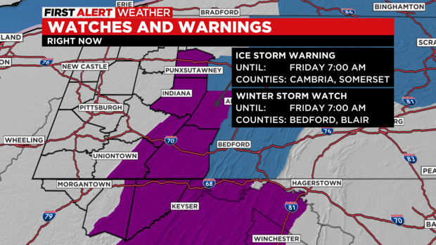
Most of the ice will start forming around midnight then last into Thursday morning. The Pittsburgh area has a small chance to possibly see a light glaze of ice in the morning if that freezing line moves south. Be prepared in case of power outages, and avoid travel as much as possible during this timeframe. Have an emergency kit including food & water ready to go in your home and car.
Temperatures throughout the day will hover in the low to mid 30s where the storm is impacting, but lower elevations that will mainly just see cold rain will be in the upper 30s to lower 40s for highs.
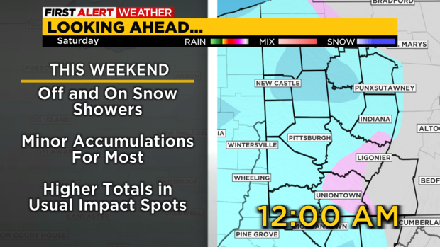
Friday will be mostly cloudy with a few peeks of sunshine with light snow showers being possible in the areas that are already seeing ice. So the only thing that could possible melt the ice would be the sun shining on those spots or temperatures above freezing.
This weekend will be very cold. Highs are only in the low 30s with mornings lows in the 20s and possibly teens. Scattered light snow will occur throughout the weekend. Then we stay under the cold air through at least Tuesday.
Stay up to date with the KDKA Mobile App – which you can download here!


