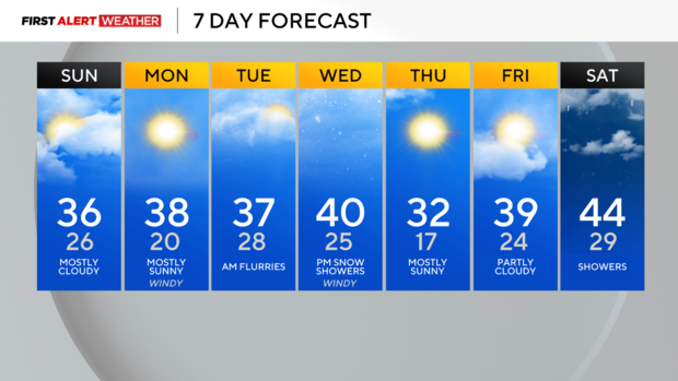
Milder start to the week with gusty winds Monday evening into Tuesday

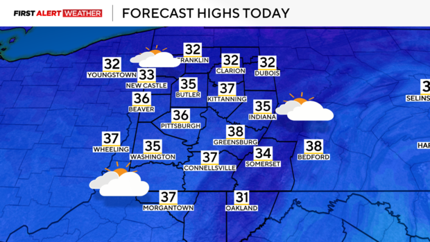
PITTSBURGH (KDKA) - A cold front continues to pass from the Lower Great Lakes and into the Ohio Valley early Sunday morning. Outside of a few early morning snow flurries in the Laurel Highlands, skies are expected to be mostly cloudy for a good portion of the day. These will be mid and high level clouds, which are generally a bit more translucent, so some filtered peeks of sun are possible at times. Our high for Sunday technically has already been reached around midnight thanks to southwest winds leading to strong warm air advection through the overnight hours. We may see a secondary peak in temperatures in the mid 30s by early afternoon as temperatures recover with the daytime heating cycle.
WEATHER LINKS:
Current Conditions | School Closings & Delays | Submit Your Weather Photos
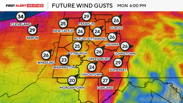
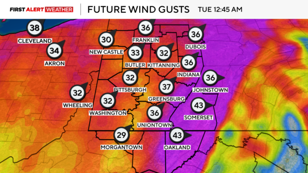
Skies will gradually clear overnight, and plenty of dry air through a deep portion of the atmosphere will lead to a mostly sunny Monday. Temperatures on Monday morning will start in the mid-teens to near 20 degrees, before quickly rising into the mid to upper 30s by afternoon and evening as westerly winds advect warm air into the region. Speaking of winds, those are also expected to increase through the afternoon and evening hours of Monday as a strong low pressure passes well to our north. Gusts by late Monday evening could approach 30-40 mph for the lower terrain west of the Laurel Highlands and Ridges, with some peaks approaching 50 mph Monday night into Tuesday. It would be a good idea to secure any loose items if you have any.
Clouds will increase ahead of a weak cold front Monday night into Tuesday. This front may carry a band of some scattered snow showers and snow flurries for Tuesday morning, especially over the northern half of our area. This cold front will stall on Tuesday across our area, before another cold front and wave of low pressure move in on Wednesday. Warmer winds will pick up again out of the southwest on Wednesday morning into mid-day, which could push our temperatures to near 40 degrees again. The cold front will pass through late afternoon into evening with some snow showers followed by a quick shot of colder air toward the middle of the week, although models have substantially backed off on how strong the cold air advection will be behind this system. High pressure will settle in on Thursday with clearing skies, but as the high moves east Thursday into Friday, that will give way to the return of southwesterly flow, warmer air and moisture which will set us up for a milder, but damp first weekend of February.
Stay up to date with the KDKA Mobile App – which you can download here!


