Live updates: Tornado watch expires for parts of Pittsburgh area
get the free appPITTSBURGH (KDKA) - A tornado watch has expired for several counties in western Pennsylvania on Tuesday night.
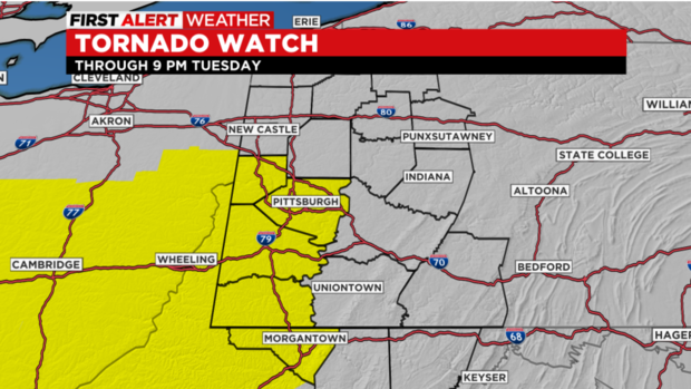
The National Weather Service issued the watch for several states, covering Butler, Washington, Lawrence, Fayette and Greene counties in the Pittsburgh area until 9 p.m. The watch expired around 8:50 p.m.
A tornado warning was in effect for parts of Allegheny and Washington counties but has since expired.
Crews are now assessing the damage after the severe weather ripped through the area. The storms and rained cause trouble all over the area, damaging homes, cars and other property.
Storm damage in Washington County caused by straight line winds
KDKA's Failcia Woody was out with the National Weather Service Wednesday afternoon while they conducted their survey of a potential tornado in Washington County.
There were a lot of downed limbs, trees snapped and downed power lines from that line of storms that moved through the area.
While even the radar loops from Tuesday night made it seem like there could be a tornado, the National Weather Service said the damage was caused by straight line winds.
McKeesport house fire
A house in McKeesport caught fire Tuesday from an apparent lightning strike.
The couple is shaken up but OK after lightning apparently hit the roof of their home, starting a fire inside the attic.
"It was just a big bang, like an explosion," Marian Pusateri said. "And I thought lightning struck a pole. I didn't think my house was hit."
Pusateri was in the living room and her husband was upstairs when it happened.
"The power went out upstairs," Pusateri said. "My husband was up there. Two bulbs flashed, they fell down. He's running around looking for light bulbs. We didn't even know it was on fire."
They did not know their house was on fire until a neighbor told them. There is smoke and water damage inside the home.
"We are OK. My dogs are OK," Pusateri said.
Power outages
According to FirstEnergy, more than 30,000 local customers are experiencing power outages.
More than 22,000 customers in Westmoreland County are without power, with nearly 10,000 more in Washington County in the dark.
You can find the latest outage numbers here.
Tornado watch expires
The tornado watch for the area has expired.
"Showers and storms will continue tonight though with the passage of a cold front," the National Weather Service tweeted.
Severe thunderstorm warning issued
A severe thunderstorm warning is in effect for parts of Indiana, Westmoreland and Fayette counties until 7:30 p.m.
Reports of damage coming in after tornado warning
After strong storms moved through the area, reports of damage are starting to come in.
In Canonsburg, which was under a since-expired Tornado Warning, KDKA meteorologist Falicia Woody saw a downed tree across Linden Road just off Route 19.
https://twitter.com/WxFalicia/status/1521617493881667585
Photos show a huge tree was ripped out of the ground in North Strabane.

Severe thunderstorm warning issued
A severe thunderstorm warning has been issued for parts of Washington, Allegheny, Westmoreland and Greene counties until 6:45 p.m.
Tornado watch extended to more counties
The tornado watch has been extended to include parts of Allegheny, Greene, Washington and Beaver counties.
It also now includes Marion, Monongalia, Wetzel, Brooke, Hancock, Marshall and Ohio counties in West Virginia.
Tornado warning issued for Washington, Allegheny counties
A tornado warning is in effect for parts of Washington and Allegheny counties until 6:15 p.m.
The National Weather Service said a severe thunderstorm capable of producing a tornado was located over McGovern, near Canonsburg, moving east at 45 mph.
Severe weather watch
The National Weather Service has issued a severe thunderstorm warning for parts of Washington, Allegheny and Beaver counties until 6 p.m.
Severe thunderstorm warning
A severe thunderstorm warning has been issued for parts of Greene and Washington counties until 4:45 p.m.
"A Severe Thunderstorm WARNING is in effect for Greene and Washington Counties until 4:45pm," KDKA Meteorologist Ray Petelin tweeted. "Damaging winds of 70 mph and large hail possible. This storm also shows weak rotation at the moment, but will need to be watched carefully. STAY AWARE OF THE WEATHER THIS EVENING!!!"
Several counties under tornado watch
A tornado watch was issued for Kentucky, Ohio, Pennsylvania and West Virginia. It covers Butler, Washington, Lawrence, Fayette and Greene counties in the Pittsburgh area.
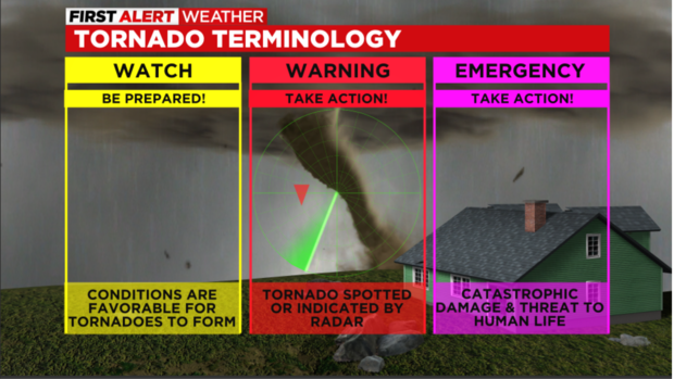
A "watch" means you should be prepared. Conditions are favorable for tornadoes to form. If a "warning" is used, that means a tornado was spotted or indicated by the radar and you need to take action.
First Alert Weather Day issued for Tuesday
A First Alert Weather Day is in place for Tuesday because of the chance for severe storms.
Aware: Showers and rain arrive just around lunch and last through the afternoon.
Alert: It's a First Alert Weather Day with strong to severe thunderstorms developing after 4 p.m. and lasting through around 10 p.m. There's the possibility for damaging winds and an isolated tornado is possible. A Tornado Watch is in effect for several counties until 9 p.m.
Tuesday temperatures will be mild with highs approaching 70 amid warm and moist airflow. Showers and rain move in through the afternoon with a trailing cold front arriving late this afternoon. That sets the stage for another round of strong storms with our area in the slight risk category from the Storm Prediction Center.
Storms that reach severe levels will have the biggest threat of causing damaging wind and we can't rule out a chance of an isolated tornado. The timing of the severe weather will be mainly between 4 to 10 p.m.
After the cold front passes, skies will gradually clear with a sprinkle around in the wee hours of Wednesday morning. Otherwise, we'll look for some drier air to arrive through the day Wednesday and more dry time on Thursday.
Showers return at times Friday and Saturday but Sunday looks dry and pleasant for Mother's Day. Temperatures all week stay seasonable in the 60s.