With snow storm over, what you need to know about weather after Saturday


PHILADELPHIA (CBS) -- Saturday's morning snow storm has come and gone. Crews have gotten to work clearing roads across the region as the overnight accumulation gave way to a sunny, windy and raw sort of day.
READ MORE: Pennsylvania, Lehigh Valley, South Jersey snow totals: How much snow did we get on Saturday?
The storm dropped as little as two inches at Philadelphia International Airport and over a foot in parts of the Lehigh Valley, Upper Bucks and Upper Montgomery Counties, where a mesoscale band set up overnight and snow fell at rates of three to four inches per hour.
Down in King of Prussia, drivers used caution Saturday morning as they forged their way through the second storm this week to drop several inches of snow on the Delaware Valley.
Though speed restrictions were in place on some roads, by 10 a.m., PennDOT had lifted its restrictions after crews made progress on the roads.
"PennDOT is continuing to treat roadways in the area and will continue until roads are clear," the department said in a statement.
Public works crews in New Jersey pre-treated sidewalks and roads ahead of the winter storm making it safe for people to go about their days and easy for businesses, like Moore Bagels in Moorestown, to open up shop.
What's next after Saturday snow?
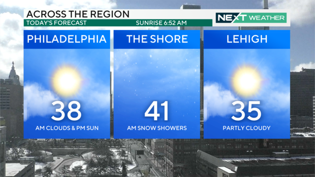
With the snow moved out, the rest of Saturday is looking cloudy, windy and raw with some peeks of sunshine.
Temperatures are getting above freezing, with a high of 38 degrees.
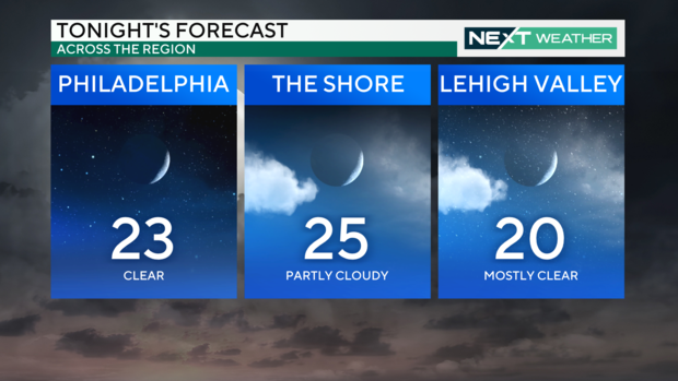
Saturday night, temperatures bottom out about 10 degrees below freezing, creating some risk of refreezing in wet spots. Keep an eye out if you're walking or driving and be sure to salt your steps if they're still wet tonight.
Sunday is sunny and seasonable with a high of 42. Highs stay in the 40s through midweek and then we see the 50s arrive Wednesday ahead of the next storm, likely bringing rain Thursday night into Friday.
Here's your 7-day forecast:
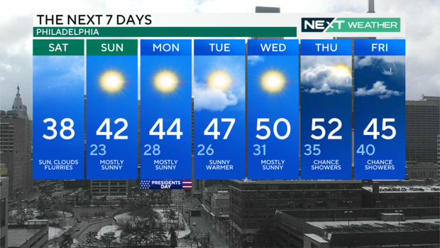
Saturday: Sun, clouds and flurries. High 38
Sunday: Mostly sunny. High 42, Low 23
Monday: Mostly sunny. High 44, Low 28
Tuesday: Sunny, warmer. High 47, Low 26
Wednesday: Mostly sunny. High 50, Low 31
Thursday: Chance showers. High 52, Low 35
Friday: Clouds and rain. High 45, Low 40
Get the latest weather info on the CBS News Philadelphia app.


