Philippe, now a post-tropical cyclone, on track to drench parts of New England, Canada
Philippe weakened from a tropical storm to a post-tropical cyclone Friday, but it still could bring another round of strong wind and rain to parts of the U.S. Northeast and Canada's southeast Atlantic coast this weekend, as the weather system continues on a path heading north in the Atlantic, forecasters said.
Heavy rains and gusty winds caused by the remnants of Philippe, coupled with a cold front approaching from the West, will start late Friday and peak Saturday afternoon and evening in the New York tri-state area, Mike Bettes, a meteorologist with The Weather Channel, said Friday.
Winds could be 25 to 30 mph on the New England coastline, Bettes said.
According to the National Weather Service, portions of upstate New York and New England could see flash flooding, with eastern Maine specifically at risk of heavy rainfall.
The storm is expected to reach Atlantic Canada by Sunday, but will have likely diminished significantly by that time, forecasters said.
New York Gov. Kathy Hochul warned New Yorkers in a statement Friday evening that while the rainfall from Philippe was not expected to be as severe as the record rainfall that flooded the New York metropolitan area last month, the impact could still be devastating.
"While it's unlikely we hit the volume of rainfall we saw last week, the ground in New York City has been so saturated that we could once again see flash flooding in high-risk areas," Hochul said. "In particular, individuals living in basement apartments that have flooded in the past should immediately make an evacuation plan."
In its final advisory late Friday morning, the National Hurricane Center said Philippe was swirling over the southern Atlantic about 110 miles south of Bermuda. The storm was packing maximum sustained winds of 50 miles per hour and tracking north at around 16 mph.
Philippe path and forecast
Forecasters expect Philippe to pick up speed as it travels toward the U.S. Northeast and Canada over the next several days.
The National Hurricane Center advisory said the storm was likely to pick up speed through Saturday night and, taking "a turn toward the north-northwest" after passing near Bermuda on Friday. Philippe was forecast to reach New England and eastern Atlantic Canada late Saturday or early Sunday.
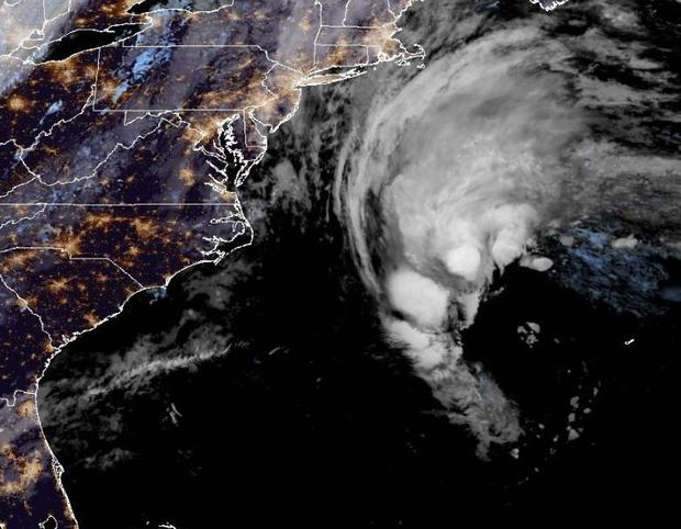
For "portions of New York and New England, rainfall amounts of 1 to 3 inches, with local amounts of 5 inches, are expected with Philippe as it moves through the region this weekend," the hurricane center said. "Isolated to scattered instances of urban and flash flooding are expected."
Large swells were already affecting Bermuda and were expected to continue for several more days, the hurricane center said, adding that these conditions could cause life-threatening surf and rip currents. However, a tropical storm warning for Bermuda was canceled Friday.
Tropical cyclone is an umbrella term that refers to any weather phenomenon characterized by rotating, low-level systems of clouds and thunderstorms that form over tropical or subtropical waters, according to the National Oceanic and Atmospheric Administration. Once a tropical cyclone's maximum sustained wind speeds exceed 39 mph, it is considered a tropical storm. A post-tropical cyclone is one that "no longer possesses sufficient tropical characteristics to be considered a tropical cyclone," the National Weather Service writes, warning that it can carry strong wind and heavy rain either way.