Tropical Storm Philippe and Tropical Storm Rina could merge, National Hurricane Center says
Two tropical storms moving over the Atlantic Ocean could potentially merge, the National Hurricane Center said Thursday, although several variables were still in play and it was unclear whether the consolidation of Tropical Storm Philippe and Tropical Storm Rina would actually happen.
Where are Philippe and Rina located?
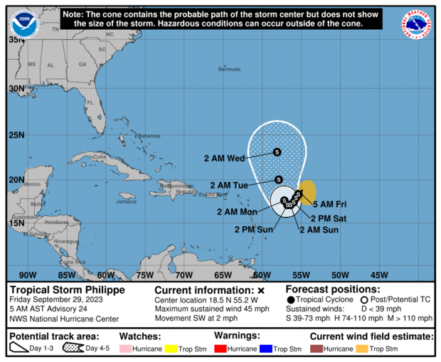
Tropical Storm Philippe has been moving slowly over the Caribbean Sea. It is forecast to maintain its speed over the next few days while remaining east of the northern Leeward Islands, the National Hurricane Center said in a Friday morning advisory.
At the time, Philippe was situated about 520 miles east of the northern Leewards, with maximum sustained winds of 45 miles per hour. The storm was expected to move gradually westward or southwestward without much fluctuation in strength through the rest of the week, with some strengthening possible over the weekend.
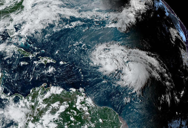
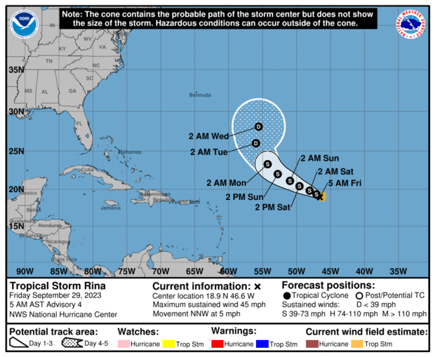
Tropical Storm Rina formed on the heels of Philippe over the central part of the tropical Atlantic Ocean. As of Friday morning, it was located over 1,000 miles east of the northern Leewards, with maximum sustained winds of 45 mph. Rina was expected to continue moving west-northwest over the next several days and could strengthen slightly, according to the hurricane center.
No coastal watches or warnings linked to Philippe or Rina were in effect Friday and there were no marked hazards to land, but meteorologists noted that the northern Leeward Islands, the U.S. and British Virgin Islands and Puerto Rico should "monitor the progress" of Philippe.
"Philippe remains a very disorganized and elongated storm," forecasters said, adding that "confidence is very low on the storm's position" and said it may no longer have a "well-defined center."
Rina is expected to remain a tropical storm into next week, "though some of the regional hurricane models do indicate a faster rate of intensification during the next several days compared to the NHC," forecasters said Thursday. The hurricane center predicted that Rina's consistent wind shear coupled with the close proximity and uncertain interaction with Philippe would limit its ability to intensify.
The hurricane center noted that forecasting Philippe's path is "challenging," partially because of how close it is to Rina.
"A complicating factor to this track forecast is the proximity of an area of disturbed weather to the east of the cyclone," forecasters said Thursday morning. "Some models are still showing a binary interaction between the two systems, which will largely depend on the strength of each."
What is binary interaction?
Binary interaction between two tropical storms, or two hurricanes, is an uncommon phenomenon also known as the Fujiwhara Effect. It happens when two storms passing near each other "begin an intense dance around their common center," according to the National Weather Service.
In some instances, the stronger storm can absorb the weaker one. If the two storms are comparable in strength, they can gravitate toward each other "until they reach a common point and merge, or merely spin each other around for a while before shooting off on their own paths." But in rare instances, the National Weather Service said, the merging of two storms can produce a single, larger storm.