NEXT Weather: Coastal flooding concerns along Delaware River, Wind Advisory in effect


PHILADELPHIA (CBS) -- Following last night's rain and wind our skies will slowly clear, high winds will return and temperatures will fall quickly.
A Wind Advisory is in place through 5 p.m. Saturday evening for gusts possibly as high as 40-50 mph. There is a concern that any loose power lines, weakened trees and branches could come down creating dangerous situations and additional power outages.
A Coastal Flood Warning is in place for areas along the Delaware River until 7 p.m. Saturday. As of Saturday afternoon, the latest hydrologic forecasts showed major flooding at high tide in Burlington, N.J. near the Delaware River.
Moderate flooding was observed and forecasted just over the bridge in Philadelphia at the Washington Avenue monitoring station.
Our NEXT Weather team will be keeping an eye on flood levels and keeping you updated as the tides change.
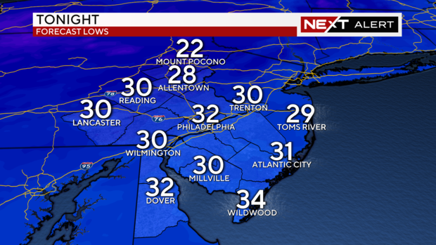
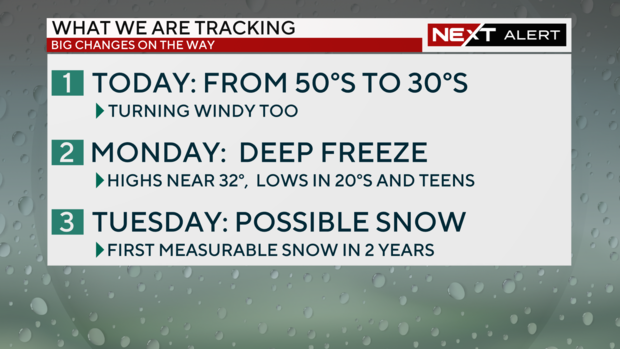
Another big change Saturday will be the drop in our unusually warm temperatures which hovered near 60 before sunrise. They will steadily fall to the 30s by this evening and hit the freezing mark overnight into Sunday. This is the second time this week we have experienced a huge diurnal temperature swing with our highs in the morning rather than the afternoon.
Looking ahead we are tracking some weekend snow showers, a dangerous Arctic blast and possibly, our first accumulating snow of the season on Tuesday.
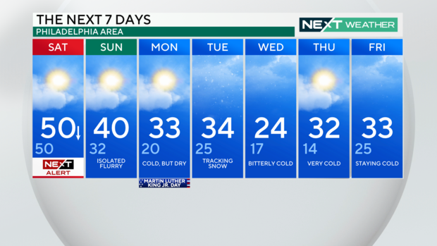
On Sunday windy conditions will continue with gusts as high as 40 mph under partly sunny skies. A weak disturbance rolls past in the morning and early afternoon with a chance of snow showers or a brief wintry mix. A dusting to 1 inch of snow is possible under the more vigorous snow showers.
Sunday may be the warmest of the next seven days with highs between 35 to 40 degrees.
Temperatures will dip below freezing Sunday nights and any flood water left standing will turn to ice.
On Monday, Martin Luther King Jr. Day, high pressure will deliver sunny skies and a dangerous cold as an Arctic blast begins to slide into the area. Highs will be at or below freezing and lows in the teens. The frigid air will be the coldest we have seen since February 4, 2023 when Philadelphia's low dipped to 15 degrees overnight.
Be prepared as the following impacts could be at play as the cold comes in: frostbite, unwinterized pipes could burst, standing water turning to ice, car issues, fires from improper use of space heaters or stoves for warming.
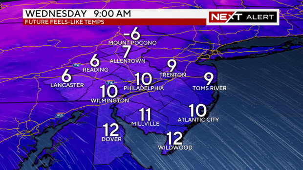
This Arctic air will settle in for much of next week with the possibility of temperatures remaining below freezing for 72 hours or more. Wednesday will be the coldest day with highs in the teens to mid 20's and lows in the teens and single digits.
Monday overnight and Tuesday, our NEXT Weather team is also tracking the possibility of snow across the area. Our meteorologists' models show Tuesday could bring some light snow with some other smaller accumulations possible.
This will be dependent on the track and timing of a coastal low and a fast jest stream overhead. It is too early to forecast any snow totals but some accumulation is looking more likely. This could be our first measurable snow in two years for much of the area.
The NEXT Weather Team is also tracking another storm may pass close enough on Friday for an additional chance of snow showers.
Your 7-day forecast
Get the latest weather info on the CBS News Philadelphia app.


