NEXT Weather: Powerful storm headed toward Philadelphia area for holiday weekend

Get our latest weather updates in our NEXT Weather blog.
PHILADELPHIA (CBS) -- A large and powerful winter storm will impact much of the nation into the Christmas holiday weekend, and the Philadelphia area is no exception.
While this at one point looked like it might hold the promise of a White Christmas, those hopes have largely been dashed in favor of a warmer system bringing heavy rain and strong winds ahead of a brutal arctic blast.
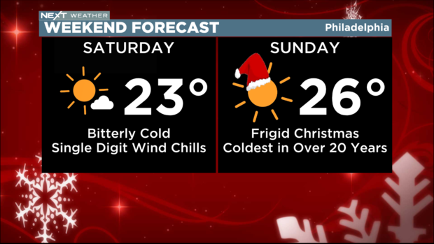
So while it likely won't be white for Christmas, it will certainly feel like winter, with high temperatures Saturday and Sunday only in the 20s.
The last time Christmas Day was in the 20s was in the year 2000.
This is setting up to be the coldest Christmas in over 20 years, and major travel delays are likely Thursday and Friday.
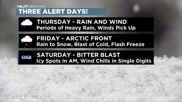
This system will impact our area in three parts, and we have three NEXT Weather Alert days issued to cover all the dangerous impacts.
Thursday: Rain and Wind
Friday: Arctic Front and Drastic Drop
Saturday: Bitter Blast
Thursday
Rain will overspread the area mid to late morning. It may hold off until after the bulk of the morning commute for areas northwest of Philadelphia, but will quickly pick up in intensity.
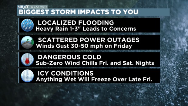
Periods of heavy rain are likely throughout the day Thursday, with 1 to 3 inches likely. This will be enough to lead to the risk of localized flooding, possibly for the evening commute.
Winds will pick up in intensity throughout the evening hours, eventually gusting to over 30 mph late, stronger at the coast.
Friday
Friday is quite an interesting day. It starts warm, with scattered morning showers and temperatures in the 50s. Winds will gust to 30 mph out of the southwest.
Between 9 a.m. and noon, an arctic cold front will sweep across the region. This will feature rain showers and quite likely a brief burst of snow.
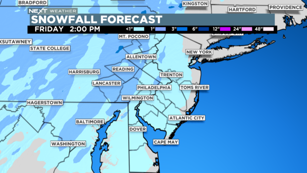
It's still unclear whether the snow will last long enough to amount to anything, but there is the possibility of a quick coating to an inch, especially on the grass.
Behind the front, winds will become WNW and continue to howl, with gusts to 40 mph possible. These gusts may be strong enough to cause scattered power outages.
By Friday afternoon, temperatures will rapidly drop to the 20s with wind chills in the teens.
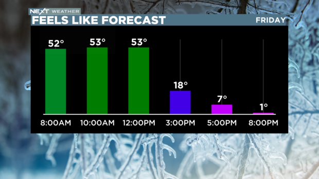
By Friday night, expect sub-zero wind chills.
Though the wind will help dry out the roads, the temp will drop rapidly enough to cause the risk of a freeze, leading to possible icy spots on area roads.
Please exercise extreme caution if traveling late on Friday.
Saturday
Saturday, Christmas Eve, is bright and sunny, but dangerously cold.
The high will stay in the low 20s all day with wind chills likely in the single digits. This kind of cold can lead to frostbite if the skin is exposed for any extended length of time.
There may be some lingering icy spots out there Saturday morning, and we stay in the deep freeze Saturday night into Christmas morning.
Santa might be used to this kind of cold at the North Pole, but we certainly are not here in Philadelphia.


