Haiti braces for Tropical Depression Grace as Fred takes aim at Florida
Tropical Depression Grace began to drench earthquake-damaged Haiti on Monday, threatening to dump up to 15 inches of rain on a landscape where people are huddling in fields and searching for survivors of a 7.2 earthquake. Tropical Storm Fred grew stronger as it approached northwest Florida, and a third tropical system was forming off Bermuda.
Air Force Reserve Hurricane Hunter aircraft determined that Fred's maximum sustained winds increased to nearly 60 mph and that the tropical storm was shifting eastward. By 11 a.m. EDT, it was 55 miles south-southwest of Apalachicola, Florida, moving north at 10 mph. Landfall in the eastern Florida panhandle was expected Monday afternoon on a path through the southeastern U.S. on Tuesday.
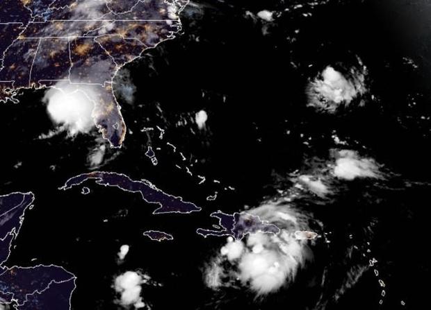
Grace, meanwhile, was crossing over the Dominican Republic's southern Barahona peninsula with top winds of 35 mph, bearing down on Haiti's disaster area with what forecasters said could total 10 inches of steady rainfall, and still more in isolated areas. The National Hurricane Center warned that flash floods and mudslides were possible, especially along Hispaniola's southern coasts.
The oncoming storm couldn't come at a worse time for Haitians struggling to deal with the effects of Saturday's 7.2 magnitude earthquake, blamed for nearly 1,300 deaths.
Grace was centered 85 miles southeast of Port-au-Prince, Haiti, and moving west at 15 mph. It was expected to pass near Hispaniola's southern coast on Monday, and become a tropical storm again as it passes between Cuba and Jamaica Tuesday on the way to Mexico's Yucatan peninsula. A tropical storm watch was in effect for the entire southern coasts of the Dominican Republic and Haiti, most of the southern coast of Cuba and the Cayman Islands.
The U.S. National Hurricane Center said Fred's main threats are rainfall and storm surge. Forecasters expected Fred to sustain 4 to 8 inches from Alabama across Florida's Big Bend and Panhandle, and even a foot of rain in isolated spots, while the surge could push seawater of between 3 to 5 feet onto the coast between Florida's Indian Pass and the Steinhatchee River.
Forecasters warned that Fred also could dump heavy rain across a swath of the southeastern U.S. and into the mid-Atlantic states, with flash floods as some rivers overflow and even landslides along the Blue Ridge mountains on Tuesday.
Along Panama City Beach in Florida's Panhandle, lifeguards have hoisted double-red flags, warning beachgoers against going into the Gulf of Mexico. The area braced for rain and some wind from the storm, and while no evacuations were ordered, schools and government offices were closed on Monday.
On the Alabama coast, the city of Orange Beach offered sand and bags to residents worried about flooding. A half-dozen school systems shut down Monday in southeast Alabama, where as much as 6 inches of rain was possible, and a large church opened as a shelter.
"We've certainly been in a lot worse than this, but that's no reason to be complacent," said Florida's Bay County Sheriff Tommy Ford. "The less people out on the road, the better. We do expect some heavy rain from this storm."
Meanwhile, the season's eighth tropical depression formed late Sunday near Bermuda, and the hurricane center predicted it would become a tropical storm sometime Monday as it circles around the island, about 135 miles offshore. A tropical storm watch was in effect for the island as the system's top winds grew to around 35 mph.