Sudden stratospheric warming could mean wild winter storms ahead
In the span of a week, from late December to early January, temperatures high in the atmosphere above the Arctic jumped by 100 degrees Fahrenheit. While this may sound alarming, it's a natural phenomenon that happens every couple of years, but experts say human-caused climate change may be making these events more likely.
The remarkable event is called a Sudden Stratospheric Warming (SSW), and it involves the temperatures 50,000 to 100,000 feet above the ground. It disrupts the typical winter climate pattern in the Arctic stratosphere famously known as the polar vortex, and typically leads to more extreme winter weather in parts of the United States.
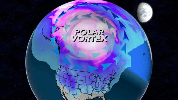
The polar vortex is a huge low-pressure gyre of cold winds spinning counter-clockwise, which rotate quickly around the Arctic Circle from west to east. But when an SSW occurs, if it is a strong enough event, winds will often reverse and become easterly, and the polar vortex will split into two or three separate vortices, which then drift southward towards the mid-latitudes carrying cold air along with them.
In most cases the SSW propagates down through the clouds to the Earth's surface over the course of a few weeks. When this happens it throws the Arctic upper-level wind patterns off-kilter and the domino effect leads to convoluted jet stream patterns around the world in the mid-latitudes like Canada, the U.S., Europe and Asia. That means it will almost certainly result in some extreme winter weather, and given the expected pattern in the U.S., that will most likely happen along the East Coast.
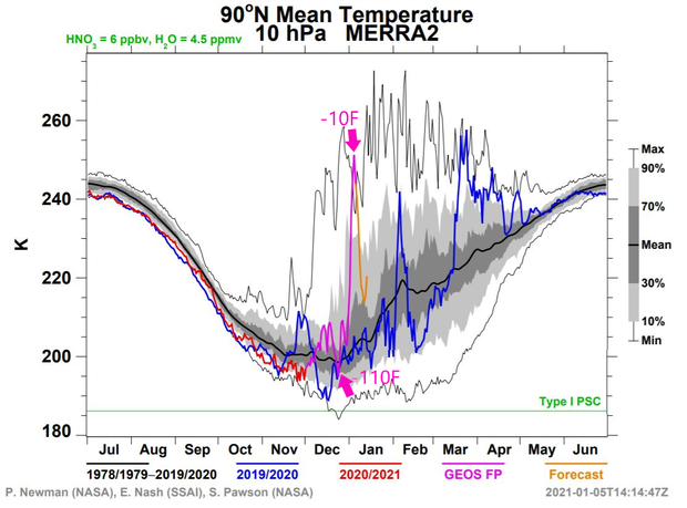
The SSW that is happening right now is in fact characterized as a "major" event. Since late December temperatures have increased from around minus-110 degrees Fahrenheit to minus-10 degrees — a jump of 100 degrees — at a height of 100,000 feet above the North Pole.
In the image below the purple line shows the abrupt heating this past week, compared to the much flatter black line which is the average temperature.
Causes of sudden stratospheric warming
Dr. Judah Cohen is an expert on sudden stratospheric warming events and the connection between changes in the Arctic and mid-latitude weather patterns at Atmospheric and Environmental Research (AER), a Verisk company.
He says the beginnings of the sudden warming in the stratosphere starts much closer to the ground, in a layer of the atmosphere called the troposphere. But in order for this abrupt disruption to reach upward from the troposphere into the stratosphere, you need the excess energy of an extreme weather pattern — something that has been in no short supply lately in the Arctic.
When all the numbers are crunched, 2020 will be one of the warmest if not the warmest year on record in the Arctic. This is especially true in northern Asia near the Barents, Kara, Laptev and Siberian Seas, where parts of the region averaged a remarkable 10 degrees Fahrenheit above normal.
Even for an Arctic that is warming at three times the pace of the rest of the globe due to climate change — a phenomenon known as Arctic amplification — this is an extreme departure from normal. The result was record-breaking low sea-ice extent near the Siberian coast.
According to Cohen's theory, the lack of sea-ice and the fact that it took a few weeks longer than typical to recover this autumn set into motion a chain of events where the typical prevailing winter jet stream pattern across Asia was enhanced. That enhancement in turn helps initiate the Sudden Stratospheric Warming.
The animation below is an idealized illustration of the effect, in which there is an enhanced heat dome (known as a ridge) over northwest Russia and an enhanced dip in the jet stream (known as a trough) in eastern Asia and the North Pacific.
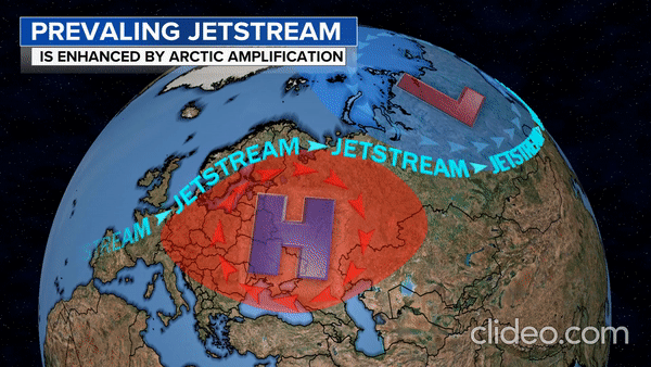
The jet stream is a river of fast-flowing air in the upper atmosphere which guides storms from one place to another. Just like waves in the ocean, it undulates up and down, from north to south, as it flows around the Earth. These undulations are known as atmospheric waves. And while most of the energy flows around the globe horizontally, some of the wave energy can move vertically, transferring energy upward or downward, especially when those waves are amplified.
Cohen explains that any given time the wave pattern is naturally elongated over Eurasia as compared to the rest of the globe. In a typical pattern this would have no impact on the stratosphere. But when this already large wave becomes even more enhanced by Arctic amplification, the energy in the wave can propagate upward into the stratosphere and cause chaos.
This connection between the warm Arctic, low sea-ice cover and an amplified jet stream is the reason why Cohen believes climate change is leading to more frequent SSWs. But he acknowledges that the topic is controversial.
And while the theory behind the connection makes meteorological sense and some studies do support the connection, Dr. Zack Labe, an Arctic climate scientist at Colorado State University, says you can find an equal number of scientific papers finding a connection versus no connection. "Due to all of the chaos and noise in our atmosphere, it still remains challenging to understand connections between Arctic climate change and the polar vortex, explains Labe. "This topic remains an active area of scientific research and debate."
But in a recent paper, Labe was indeed able to find a robust connection between Arctic amplification and a stronger, colder area of high pressure over eastern Siberia, something that is a key to Cohen's theory. Labe's analysis finds that this effect will intensify if global warming gets worse.
Cohen theorizes that the warming process underway in the stratospheric Arctic right now was initiated in October. In northwest Russia and Scandinavia, the warmer Arctic Ocean results in an enhanced heat dome which pushes the jet stream north.
With less sea-ice cover due to a warmer Arctic, the overlying atmosphere absorbs more moisture from the Arctic Ocean and, when it is cold enough, dumps more snowfall east of the heat dome. That snow cover, Cohen says, creates an extra-cold air mass over interior Siberia, Kazakhstan and Mongolia. This colder air has the opposite effect on the jet stream in eastern Siberia and the northern Pacific, pushing it south.
In what is not likely a coincidence, this pattern yielded two astonishing records last week. On December 28, the unofficial highest pressure ever recorded on Earth happened in Mongolia.
Then just three days later the opposite occurred: the North Pacific and Alaska recorded their lowest pressures on record as a huge Aleutian low reached a pressure as low as a Category 5 hurricane.
"I would argue that all these events are linked," says Cohen, "A strengthened Siberian high coupled with a deep Aleutian low are critical for triggering a Sudden Stratospheric Warming. Most important in my opinion is the Siberian high but coupled with a deep low in the North Pacific is a one-two knockout punch."
In other words, processes in the atmosphere do not happen in a vacuum — everything is connected — so one extreme can sometimes help yield another. And this "one-two punch" was an amplified enough pattern to send energy into the stratosphere, causing the sudden warming and polar vortex disruption.
Extreme winter weather pattern coming up
Cohen says that after a stratospheric warming event, the biggest impacts typically follow in about two weeks as the atmosphere shuffles systems around and new patterns become established. The timing and degree varies from event to event.
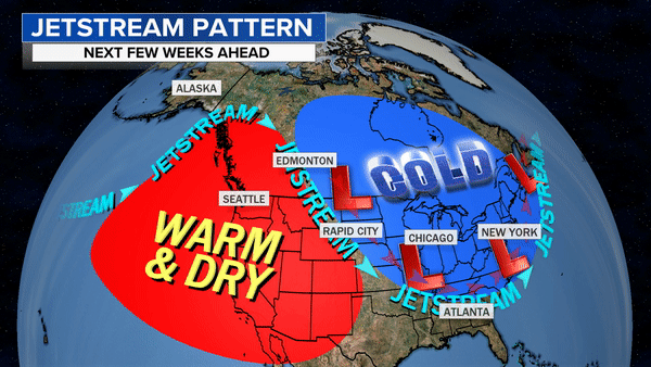
In the Arctic the sudden warming in the stratosphere typically leads to blocking areas of high pressure — like a mountain of warm air — known as the negative Arctic oscillation, or -AO. As it turns out, the -AO is already underway and this SSW episode should act to prolong it. This blocking pattern forces and redirects the jet stream and cold Arctic air southward.
For this particular SSW event it appears the main Arctic outbreak will occur first over Europe and eastern Asia through mid-January. But then computer models show a shift occurring, with the potential for Arctic invasions in the U.S. later this month.
Along with a gradual building of cold air over the coming weeks in the East, the jet stream setup will provide many opportunities for snow storms. While many will not materialize, with a prolonged pattern favorable for extreme winter weather, odds are that pieces of the puzzle will come together for a couple of memorable winter storms.
Cohen warns that the chance for extreme winter weather may last for quite a while. "Following an SSW the period of increased risk of cold air outbreaks and snowstorms usually lasts from four to eight weeks. It is not cold and snowing continuously but rather it is episodic," he explained.
After years of studying these phenomena, Cohen says a clear pattern has emerged. Warm Arctic conditions and a weaker stratospheric polar vortex, is linked to more cold extreme episodes in some parts of the mid-latitudes.
This is not to say that winters are getting colder in the mid-latitudes. To the contrary, overall winters are warming due to climate change, although some pockets are indeed warming more slowly because of this effect. That's because these types of mid-latitude cold air episodes are made more likely by Arctic amplification, and research has found an increasing frequency in weak polar vortex states over the past four decades, linked to human-caused climate change.
For the U.S. the trends are clear: Cohen's research shows a direct connection between intense warming events in the Arctic and more episodes of extreme winter weather in the eastern U.S.
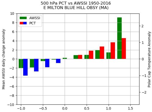
In the below graph for the city of Boston, the blue lines indicate a cold Arctic, the red lines indicate a warm Arctic, and the green lines represent the Accumulated Winter Season Severity Index (AWSSI), a measure of snow and cold. Cohen points out just how straightforward the trend is: As the Arctic warms (red), cold and snow (green) increase in Boston. This is especially true following episodes of major Arctic warming, as is happening now. This is also the case for much of the eastern U.S.
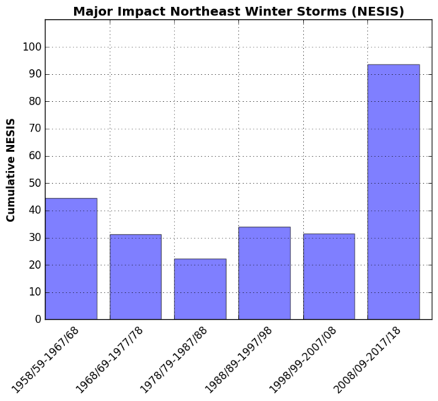
In what may seem paradoxical, as global warming has intensified in recent years, the number of big Northeast snowstorms has increased. In fact, many of the biggest snowstorms in New York City history, like the January blizzard of 2016, have happened in the past two decades. While some of this may be related to natural variability, Cohen feels changes in the Arctic clearly play a role.
In the bar graph below, the Northeast Impact Snowfall Scale (NESIS) is plotted for each decade from 1958 through 2018. You can clearly see the spike in activity in the last decade shown, 2008 to 2018.
It should be noted that this trend in bigger snowstorms is likely also due to other factors related to a warmer climate like warmer ocean temperatures, more available moisture and more intense storms due to extra energy in the system.
This means, for now, climate change can lead to bigger snowfalls for areas where there's more moisture and it is still cold enough to snow, like the Midwest and Northeast. But in areas where temperatures are warming above thresholds for snow more often, like the nation's midsection, the trend in snowfall is downward. The below image makes this trend clear.
So, for at least the next few weeks, if you live in the eastern half of the nation, prepare for real winter weather and the possibility of snow.