What is a red flag warning and what areas are at risk?
On the heels of a frosty winter season that brought record-low temperatures to parts of the Northeast, the sudden onset of warm weather this month has come alongside a pattern of red flag warnings seen recently across large sections the U.S.
The National Weather Service issues these advisories to alert people about increased risks of fire in their areas. In addition to formal bulletins released by the agency, red flag warnings appear in banners at the top of daily or weekly forecasts in smartphone weather applications. Intentional burns are strongly discouraged while they are in effect, from prescribed blazes scheduled routinely on federal lands to more ordinary hazards, like improperly disposing of a match or cigarette from inside a moving vehicle.
What is a red flag warning?
Red flag warnings are issued when forecasts indicate that a combination of high temperatures, very low humidity and strong winds in a given location could create an environment that is conducive to dangerous fires, according to the National Weather Service. The agency sets these warnings most often between February 1 and April 30, and again from October 1 to December 15, when typical weather conditions are consistent with that criteria.
More specific criteria established by the National Weather Service, in coordination with government land management agencies, uses thresholds to determine whether a red flag warning should be issued, when it should be issued and for how long. The criteria considers fuel conditions — a parameter that refers to the amount of water held by "small vegetation," like grass, leaves and mulch, which indicates how the land could respond to either wet or dry environmental changes — when they have reached a critical point that could be favorable to the growth and spread of large fires, according to the agency.
Criteria also stipulates that a red flag warning is issued when relative humidity in an area drops to about 25% while surface winds or frequent gusts simultaneously climb to at least 25 miles per hour. Both conditions must occur simultaneously for at least three hours over a 12-hour period. Widely scattered, dry thunderstorms could trigger a red flag warning as well, with the National Weather Service deeming a thunderstorm "dry" if it produces less than 1/10 of an inch of rainfall.
Other environmental factors that contribute to a red flag warning include: lightning, when it is significant and occurs for the first time after a hot and dry period; dry cold fronts forecasted to cause strong and gusty winds and abrupt wind shifts, but little or no rainfall, especially in areas where there are ongoing wildfires or prescribed burns; and any weather and fuel conditions that could otherwise elevate the risks of fires when taken together, like unusually high temperatures and long-term drought. In California, for example, where massive and devastating wildfires are one consequence of a lengthy and severe drought in the American West, some experts have suggested that parts of the state are now experiencing a "wildfire season" that lasts year-round.
Red flag warning vs. fire weather watch
A red flag warning is technically not the same as a fire weather watch, whose threat is more explicit, although both kinds of advisories rely on the same fundamental criteria. Fire weather watches can develop into red flag warnings if environmental conditions progress to a point of serious urgency.
The National Weather Service generally issues a fire weather watch to alert officials and the public to "the possible development of red flag conditions in the near future," often between 24 and 72 hours in advance of a forecasted weather event. Then, if necessary, it will issue a red flag warning to advise "of occurring or imminent red flag conditions, generally within the next 12 to 24 hours."
Who is at risk this season?
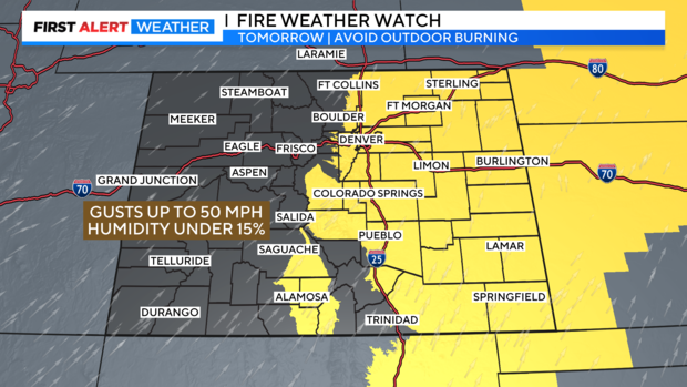
Red flag warnings are usually issued in western and southwestern U.S. states, where arid climates have historically made the land more susceptible to wildfires. Parts of those regions are still receiving red flag warnings in mid-April — one advisory that remained in effect on Thursday applied to Denver, Colorado — but the addition of numerous places also under warnings, which stretched from New Mexico to the eastern tip of Massachusetts earlier this week, prompted more widespread questions and concerns than usual about the forecast and what it could mean.
As an enormous wildfire burned nearly 4,000 acres of land in New Jersey on Wednesday, vast sections of the tristate area and New England, including New York City, southern Connecticut and the entire state of Pennsylvania, had just emerged from a smattering of red flag warnings that ultimately expired in waves. The National Weather Service noted in a bulletin shared Wednesday night that relative humidity in southern Connecticut was still quite low, but the fire hazard diminished with calmer winds.
In New York and parts of New Jersey and Connecticut, recent red flag warnings coincided with a spike in temperatures over the last 10 days or so. The heat in Newark, Islip, Bridgeport and the areas around LaGuardia and John F. Kennedy Airports broke their daily high temperature records for April 6 this year, while Central Park tied its record high, according to the National Weather Service's New York branch.
Red flag warnings had moved to parts of the upper Midwest on Thursday, with the Twin Cities and southern Minnesota under advisories that included 31 individual counties, CBS Minnesota reported. In Wisconsin, Governor Tony Evers declared a state of emergency in response to the threat of dangerous wildfire conditions touching most of the state. The same day, the Wisconsin Department of Natural Resources had reported a 100-acre wildfire in the central part of the state, about 90 miles north of Madison, which the agency attributed to warm temperatures, low humidity and gusty winds, according to CBS Minnesota.