Another round of powerful storms hitting Midwest, South
People still sorting through the wreckage of their homes after deadly weather hit over the weekend braced for another wave of strong storms, including tornadoes, that began rolling into parts of the Midwest and South beginning Tuesday evening. Officials warned residents to have shelter ready before going to sleep.
"This could be a night to just set up down in the basement to be safe," said Tom Philip, a meteorologist in Davenport, Iowa.
Early Wednesday, the National Weather Service posted a tornado watch for parts of Arkansas, Illinois and Missouri until 9 a.m. local time.
The weather service began issuing tornado warnings Tuesday evening for Iowa and Illinois and said a confirmed twister was spotted southwest of Chicago near Bryant, Illinois. No damage was immediately reported.
A tornado was also reported near the town of Pleasantville, Iowa, the NWS said. Footage obtained by CBS News showed what appeared to be a twister spinning near Pleasantville.

There were no major power outages as of late Tuesday night, according to the utility tracking website PowerOutage.us.
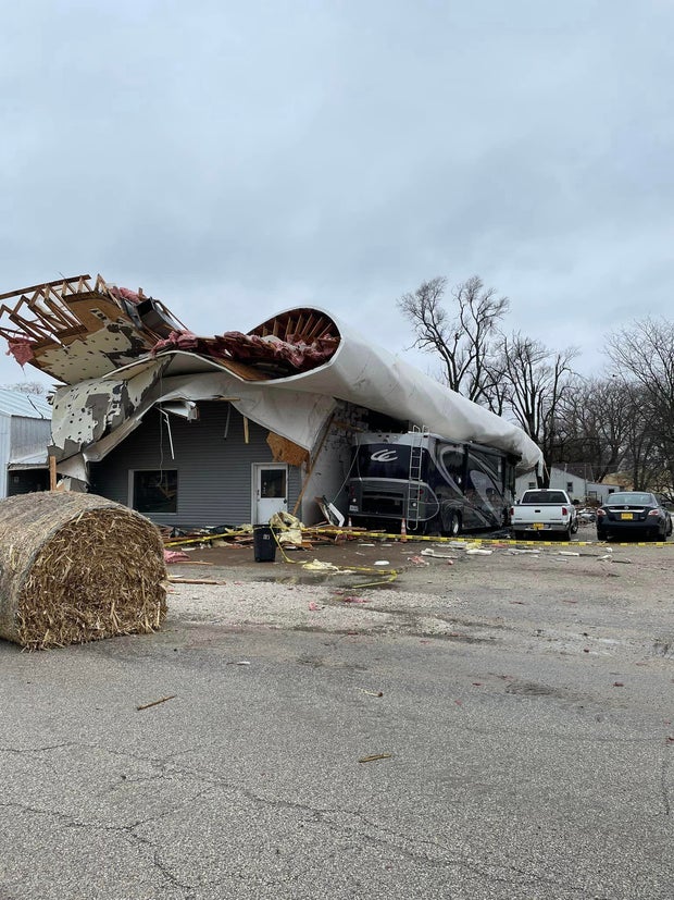
The storms were expected to hammer some areas already hit by severe weather — and possibly dozens of tornadoes — just days ago that killed at least 33 people, meaning more misery for those whose homes were destroyed in Arkansas, Iowa and Illinois. Dangerous conditions also could stretch into parts of Missouri, southwestern Oklahoma and northeastern Texas. Farther south and west, fire danger remained high.
Ryan Bunker, a meteorologist with the National Weather Center in Norman, Oklahoma, predicted that Tuesday's storm system could start as isolated supercells — with possible tornadoes, wind and hail — and "form into a line (of thunderstorms) and continue moving eastward."
Earlier Tuesday, strong thunderstorms swept through the Quad Cities area of Iowa and Illinois with winds up to 90 mph and baseball size hail. No injuries were reported but trees were downed and some businesses were damaged in Moline, Illinois.
The weather service and Illinois Emergency Management also said a tornado touched down Tuesday morning in the western Illinois community of Colona.
The Colona Police Department said the storm damaged a Shell Gas station and a building behind it. There were no injuries, the police department said, but two people were evacuated from the Shell station.
Northern Illinois, from Moline to Chicago, saw 75-80 mph winds and hail 2 to 3 inches in diameter on Tuesday afternoon, National Weather Service meteorologist Scott Baker said. The agency received reports of semi trucks tipped over by winds in Lee County, about 95 miles west of Chicago.
The tornado risk in the Upper Midwest was expected to be highest in the evening and late night Tuesday with storms targeting northern Illinois, eastern Iowa and southwest Wisconsin. Areas of southern Missouri and Arkansas were most at risk overnight.
In Keokuk County, Iowa, where 19 homes were destroyed and more were damaged Friday, emergency management official Marissa Reisen worried how those cleaning up the damage will cope if another storm hits.
"All of the people who have been impacted by the storms Friday night are doing all this work, to clean up, to gather their stuff, to pile up the debris," Reisen said. "If a storm comes through and hits them again and throws all that hard work all over the place again, it will be so deflating to those people."
Severe storms could produce strong tornadoes and large hail Wednesday across eastern Illinois and lower Michigan and in the Ohio Valley, including Indiana and Ohio, according to the Storm Prediction Center. The weather threat extends southwestward across parts of Kentucky, Missouri, Tennessee and Arkansas.
The fierce storms that started Friday and continued into the weekend spawned deadly tornadoes in 11 states as the system plodded through Arkansas and onto the South, Midwest and Northeast.
The same conditions that fueled those storms — an area of low pressure combined with strong southerly winds — were setting up the severe weather Tuesday into early Wednesday, Bunker said.
Those conditions, which typically include dry air from the West going up over the Rockies and crashing into warm, moist air from the Gulf of Mexico, are what make the U.S. so prone to tornadoes and other severe storms.
Dramatic temperature changes were expected, with Tuesday highs of 74 in Des Moines and 86 in Kansas City plunging overnight to 40 or colder overnight. In Little Rock, Arkansas, the high of 89 on Tuesday tied the record for the date set in 1880.
A blizzard warning was in effect for nearly all of North Dakota and most of South Dakota through at least Wednesday night. The National Weather Service predicted parts of South Dakota could see up to 16 inches of snow and wind gusts as high as 55 mph.
Dozens of schools in South Dakota closed Tuesday due to blizzard conditions. State executive branch offices were also closed in much of the state.
North Dakota Gov. Doug Burgum signed off on $20 million Tuesday for emergency snow removal grants to localities. Officials reminded residents to check on neighbors and keep their homes stocked with food, water and medicine, have battery-powered radios in case of power outages and ensure gas meters and furnace vents are clear of snow.
In Minnesota, a winter storm warning was in effect in the north, while the southern part of the state expected thunderstorms that could include hail and strong winds. The expected weather led the Minnesota Twins to delay their Major League Baseball home opener from Thursday to Friday.
Fire danger persisted across portions of far western Oklahoma, the Texas Panhandle, northeastern New Mexico and far southeastern Colorado, with low humidity, dry vegetation and high wind gusts. Officials issued a fire warning for Custer County in western Oklahoma and urged some residents near the town of Weatherford to evacuate their homes because of a wildfire.