Freak hailstorm dumps up to 6 feet of ice on Guadalajara, Mexico
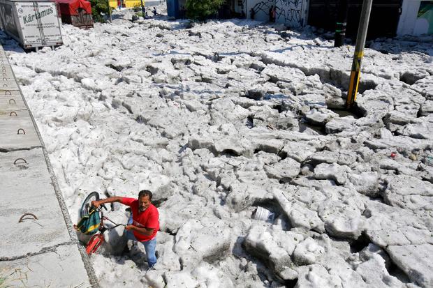
A bizarre summer hailstorm left a Mexican city buried in up to six feet of ice Sunday. The unusual weather event in Guadalajara –northwest of the capital of Mexico City – damaged homes and cars, but there were no reports of injuries.
Enrique Alfaro, the governor of Jalisco, tweeted about the government's response to the freakish hailstorm, along with photos of ice tall enough to cover vehicles' wheels. He was stunned by what he saw in Guadalajara, Jalisco's capital, and suggested climate change may be the cause of the ice storm.
"I was in the place to assess the situation and witnessed scenes I had never seen: hail more than a meter high, and then we wonder if climate change exists," he tweeted in Spanish.
Alfaro said no was hurt and vowed to have the streets cleaned up as soon as possible and through coordination with the Mexican Army and municipal authorities of Guadalajara and Tlaquepaque. The state's civil protection service said there were possible cases of hypothermia in three adults.
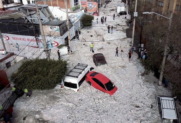
Guadalajara, one of Mexico's most populous cities, was experiencing temperatures around 88 degrees Fahrenheit in recent days. Alfaro said Guadalajara, which is located just north of Mexico City, received more than three feet of ice. However, in some places, there were up to two meters – or six feet – of ice early Sunday, Agence France Presse reported. About 200 homes have been damaged and dozens of vehicles swept away in the city and surrounding districts, according to the AFP.
CBS News meteorologist Jeff Berardelli said he has never seen a hail accumulation quite like this before and called it "remarkable." While referencing the satellite images below, he explained how this peculiar ice storm happened.
"To a meteorologist the evidence of why this was such a powerful storm can be seen in this satellite cloud loop," he said. "You can see a line of clouds, an atmospheric boundary of some sort, moving southward. The boundary could be a dividing line between dry and moist, warm and cool or simply a wind shift. Whatever it is, it seems to have ignited and/or helped feed the hail storm. The storm is feeding off warm, moist air to its north of which it has a seemingly endless supply partly because it's the only thunderstorm cluster around so it can hog all the energy, it doesn't have to share with other storm activity."
"This all lead to a tall, long-lasting storm redeveloping over the same area for an extended period of time leading to unprecedented hail piles," he added.