Tracking The Tropics: Sam Remains Major Category 4 Hurricane Heading North As We Watch Two More Systems In Atlantic
MIAMI (CBSMiami) -- Hurricane Sam remains a powerful, dangerous Category 4 storm in the Atlantic Ocean with winds of 130 mph.
Sam was centered well offshore from land Monday morning, located about 800 miles east-southeast of the northern Leeward Islands moving NW at 8 mph.
Sam is forecast to remain a major hurricane, Category 3 or higher, the next few days and hurricane hunters are scheduled to investigate it later Monday.
Sam is considered a small storm, with hurricane-force winds extending outward 30 miles from its center.
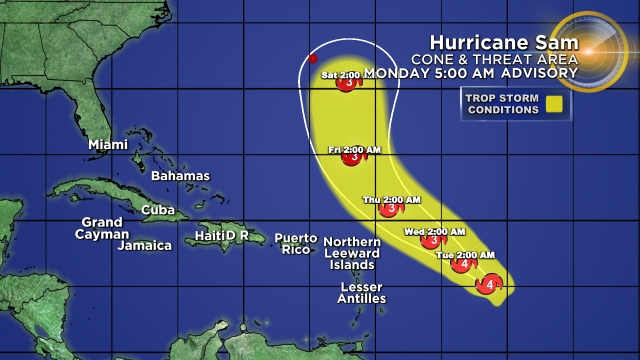
Sam is expected to stay to the northeast of the Lesser Antilles and away from the Caribbean Islands. But Bermuda will need to keep watching Sam closely since the current forecast cone shows the possibility that the center of Sam could be to the east of Bermuda later this week.
No coastal watches or warnings are in effect.

The CBS4 Weather team is also tracking an area of low pressure associated with the remnants of Peter, located a few hundred miles east-southeast of Bermuda. Showers and thunderstorms associated with this system have changed little in organization since Sunday.
However, environmental conditions are marginally conducive for some further development, and Peter could briefly become a tropical depression again during the next day or two while it moves northeastward near 10 mph. The National Hurricane Center is giving this disturbance a medium potential of cyclone development.
By midweek, environmental conditions are expected to become unfavorable for further development.
There is also a broad area of low pressure located several hundred miles southwest of the Cabo Verde Islands. Environmental conditions are forecast to be conducive for further development of this disturbance, and a tropical depression is likely to form in a few days while it moves westward to west northwestward at 5 to 10 mph over the central tropical Atlantic. The National Hurricane Center is giving this wave a high potential of development over the next 5 days.
A tropical wave is moving offshore the west coast of Africa and into the far eastern tropical Atlantic. Upper-level winds are forecast to be conducive for gradual development, and a tropical depression is likely to form in a few days while the system moves westward to west-northwestward at 10 to 15 mph over the far eastern tropical Atlantic. The National Hurricane Center is giving this disturbance a high potential of development over the next 5 days.