Kay weakens even more, no longer a tropical storm
Animated Radar | Winds Right Now | Current Humidity | Latest Video
Tropical Storm Kay off the coast of Baja California is helping to end the punishing heat wave broiling Southern California.
Kay pushed clouds and rain into Southern California, but it's unclear how big the storm's impact will be because it's expected to weaken as it moves north.
Excessive heat warnings will remain across most of Southern California through Friday and may extend into Saturday morning. And Kay pushing high winds into the region, there's significant potential for dry lightning and wildfire before there's any rain.
Long Beach residents, crews prepare for overnight high tides
Flash Flood Warning expires
Kay no longer a tropical storm
Flash Flood Warning for some areas of the Inland Empire
Monrovia residents prepare for threat of mudslides
With Tropical Storm Kay making its way through the Los Angeles County area, Monrovia residents are once again bracing for the threat of mudslides.
In Sept. 2020, the Bobcat Fire burned through the foothills above Monrovia and the terrain of the burned scar areas have not fully recovered.
Until the terrain recovers, mudslides will continue to be a threat for Monrovia residents when a storm approaches the Southland.
CBSLA Reporter Jeff Nguyen talked to residents on Friday.
Winds lessen, rains enter
The general thinking is that we may have already experienced the strongest winds across our area over the last several hours and they will probably lessen heading into and through the evening.
Some intense downpours and thunderstorms quickly swept through between Ventura and Santa Barbara this afternoon. Rain showers should become more numerous and successful in actually hitting the ground as the air moistens up across the lower to mid levels for more parts of Southern California heading into this evening.
Then, there will be potential on-and-off showers, possibly bands, through the night and into Saturday. Some areas will see more and others will see less.
If enough instability develops tomorrow thunderstorms may be possible, with the highest chances across the mountains, maybe deserts. There is a possibility area-wide including valleys and coasts but the keyword is isolated with some areas more concentrated than others. Again, if and where storms form torrential downpours will be likely.
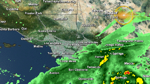
So far the NWS has been issuing Flash Flood Warnings across eastern San Diego and central Riverside Counties, where the brunt of the heaviest rain has fallen, now extending up into the Coachella Valley. In these areas, multiple inches of rain has fallen. These are desert regions where half an inch can lead to flooding so flooded roadways, creeks and streams rushing with water are creating dangerous situations that people need to avoid.
It's not every day you get tropical moisture flowing straight into very tall mountains, and that's exactly what's been happening up and down the San Jacintos.
This is good news for firefighters battling the Fairview Fire in Riverside County.
Early Friday, the wind gusts were forcing crews to scale back their aggression to combat the fire.
There was no aerial attack due to the high winds but since those are likely behind us and as the storm weakens, the hope is that Kay will bring some rain.
Kay weakening, continue to expect rain and possible floods
Seal Beach restaurant flooded as storm approaches Orange County
A new restaurant in Orange County was flooded Friday as a storm is expected to approach Southern California.
Beach House in Seal Beach had a muddy parking lot with six inches of water, according to the owners, Brian Kyle and Rosie Ritchie.
The beach-side restaurant, which is under construction, was supposed to have a grand opening in a couple of weeks. However, Kyle said he hasn't seen flooding like this in decades and is worried the patio will be next.
"Well, I kept watching the waterlines, and I was going uh oh," said Kyle.
For the full article click here.
Thunderstorms possible any moment for the Ventura area
Intense daytime heating and offshore flow have helped boost temperatures to incredible levels for the coast, where it is about 100 degrees just blocks from the ocean in parts of Ventura right now!
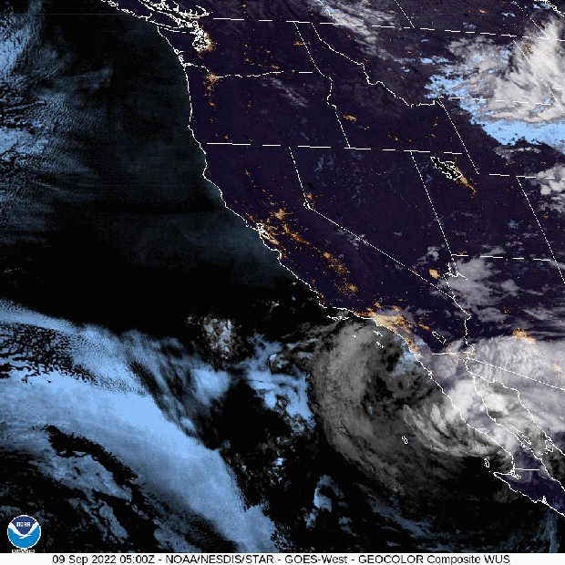
An area of sunshine ahead of the incoming cloud mass has helped temperatures get maximized and the tropical moisture in place and on the way has met up with the heat for strong instability. Visible satellite imagery confirms towering cumulus clouds around the Castaic area moving west-southwestward. The thinking is that thunderstorms may fire at any moment. If they do Ventura may be the prime zone for this in the coming hour or two.
A reminder, any thunderstorms that form today will be capable of torrential rains, perhaps on the order of 2-4 inches an hour, as far as rainfall rates. Luckily these cells should be moving along at a fairly good clip so the duration of downpours may be limited unless repetitive cells move across the same areas.
Lightning will be a threat as well as strong winds.
Also, the amount of wind shear present in a landfalling tropical system does make the atmosphere more conducive to the possibility of tornadoes and this is something that is also not out of the question if the conditions are set up to support that.
Stay weather aware out there and send us your footage @CBSLA on Twitter, Instagram or Facebook. Feel free to email us at cbsla@cbs.com.
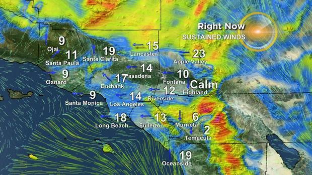
Winds picking up, rain not too far behind
The strongest winds, so far, have been across the higher elevations of San Diego County so far today. These winds are actually a combination of the tropical system AND terrain effects.
Strong winds spinning around and into an area of low pressure, which a tropical system is a very impressive example of, are one aspect of the weather scene. Another one, very particular to Southern California, is the topography (aka mountains). The winds flowing around Kay are even stronger higher up in the atmosphere and normally they would stay that way, except around these parts we've got land going on up thousands of feet up. These hills and mountains are actually poking up into the higher momentum flow and the weather observation instruments are recording those speeds.
Also, some of the mountain slopes are actually catching the higher altitude and faster wind speeds around Kay and in some cases dragging them down to the surface. These are called "mountain waves" and these can help increase the wind speeds at even lower elevations below the higher terrain.
In addition, there is a significant pressure differential between higher pressure over land and lower pressure within the tropical system over the sea, giving this a hybrid "Santa Ana wind" / tropical system interaction, a very unique situation!
For our area, winds have started to pick up out of the east and this uptick looks to continue into the afternoon. Rain is also steadily moving northwestward and should start getting those pavements increasingly wet as we head on toward evening and into the overnight.
Hurricane Kay touches down in San Diego bringing heavy winds
Parts of Southern California have already experienced hurricane force wind gusts on Friday as Hurricane Kay is expected to bring extreme weather to the Southland this weekend.
Cuyamaca Peak in San Diego County experienced wind gusts of 109 mph as of 10 a.m. on Friday. Big Black Mountain also saw heavy winds clocked out at 96 mph, according to the National Weather Service Weather Forecast.
CBSLA Meteorologist Amber Lee said that the majority of extreme wind gusts will be taking place in the San Diego mountains just west of the Anza Borrego Desert.
"The strongest wind gusts so far over the riverside county mountains were Toro Peak at 72 mph," Lee said. "Yes these winds are strong but Kay is weakening as it moves over our unique topography and the strongest impact will be over the San Diego and Riverside mountains."
Orange County and the Inland Empire will see high rain totals as Kay passes through the area.
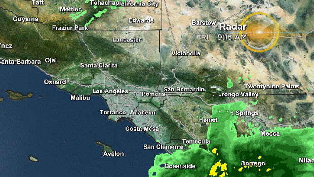
The rain is making its way to us
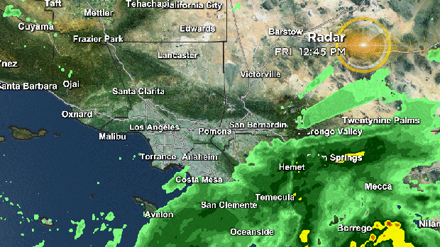
Here Is the latest animated radar showing the storm's path.
Kay weakens, but could still wreak havoc
Friday will be warm, humid and windy as Tropical Storm Kay moves into Southern California. The storm system is weakening as it moves into the region, but the region could still see heavy showers and thunderstorms from the northern bands of the storm.
Flood watches are in place for the mountains, deserts, and portions of the Inland Empire through noon Sunday.
Kay is expected to become a tropical depression as it moves into cooler ocean waters, and weaken into a low-pressure system by Saturday. And while Kay won't deliver a direct hit to Southern California, the storm will still inject a lot of moisture into the atmosphere.
Catalina Island could be in Kay's path

Catalina Island appears to be closest to the center of Kay as the tropical storm passes to the south and southwest. The roughest seas and highest waves are expected to hit the southeast part of the island early Saturday.
Calm before the storm
Kay has now weakened to a tropical storm and will continue to weaken as it tracks off the Baja coast before turning west off northern Baja by Friday night.
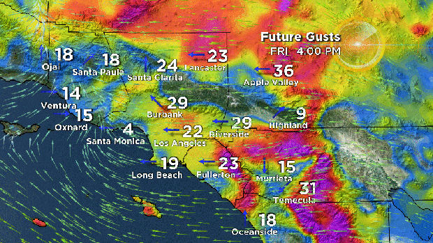
East winds will increase Friday morning ahead of the main event...just as an example, San Diego County can expect up to 80 mph winds in the mountains, and 50-60 mph at the coast and in their valleys. Rain will start from south to north Friday morning through the afternoon. Fire danger will be present before the rain as any fires would be fast spreading due to the strong winds. Rainfall by the afternoon might help mitigate the fire but will immediately turn to flash flooding potential in heavier rain bands which are now focused over the deserts and mountains, especially east facing slopes.
Impacts will include:
- Heavy rain especially in the mountains and deserts (2-4" locally up to 7") *see rainfall totals below.
- 1-2" rain near the Fairview Fire, flash flood watches up meaning flash flooding is probable.
- High winds
- Large swell
- Coastal flooding
Tropical Storm Kay is bringing a tropical airmass to the region that's not typical to Southern California. Kay could bring some significant rain totals to the region, but there is also a strong possibility for coastal flooding at the beaches and harbors.
Potential Public Safety Power Shutoffs
Before Southern California sees much rain, it will likely see gusty winds. And because the region is just now starting to emerge from the longest and hottest heat wave in recent memory, there are concerns that Tropical Storm Kay-fueled winds could spark a wildfire before dropping any moisture.
The City of Yorba Linda says SoCal Edison is considering a Public Safety Power Shutoff between the hours of 6 a.m. and 6 p.m. Friday. And in fact, SoCal Edison is considering preemptive power shutoffs for 5 million customers across Los Angeles, Orange, Riverside, San Bernardino, and Ventura counties.
Malibu bracing for Kay-fueled winds
Even with the possibility of rain this weekend, excessive heat and the potential for dry lightning is a concern for Malibu, one of the communities where the National Weather Service forecasted hazardous fire conditions. East wind gusts of 25 to 35 mph are expected later Friday over LA County Mountains and possibly the coasts.
Other hazards Kay may bring to Malibu include coastal flooding, hazardous sea and beach conditions, hazardous driving conditions, and power outages.
Because of the potential for strong winds Friday night into Saturday, Southern California Edison has notified Malibu of the possibility of Public Safety Power Shutoffs.
Seal Beach prepares for high surf
The City of Seal Beach is bracing for high surf and possible coastal flooding from Tropical Storm Kay. Surf is forecast to be 4 to 7 feet, and with 1 to 2 inches of rain expected Saturday, there is a possibility south-facing beaches could see coastal flooding.
Seal Beach is offering sandbags to residents at the Eighth Street Beach Parking Lot, 800 block of Ocean Avenue, and the Seal Beach City Yard, 1776 Adolfo Lopez Drive.
Long Beach coastal berm erodes; no property damage yet
The coastal berm that Long Beach authorities built to protect beachfront properties from high tides caused by the incoming storm have eroded.
"The tide has peaked and the berm at the Peninsula has eroded significantly," the Long Beach Fire Department posted on Instagram.
There have been no reports of property damage as of Thursday evening.
Crews are expected to work throughout the weekend to patch any holes in the berm.
"Our team is working around the clock getting this berm fortified," said Gonzalo Medina, marine safety chief with the Long Beach Fire Department.
Long Beach and Seal Beach residents can get free sandbags at these locations:
- Eighth Street Beach Parking Lot on 800 block of Ocean Avenue
- Seal Beach City Yard on 1776 Adolfo Lopez Drive
Flood Watch alert in Riverside County, including Fairview Fire area
The National Weather Service issued a Flood Watch Alert to all of Riverside County, including the particularly vulnerable Fairview Fire area.
"Based on forecasts, this appears to be a dangerous storm. We want the public to prepare now," said Bruce Barton, director of the Emergency Management Department (EMD) in Riverside County. "If you encounter a road that's flooded, never try to walk or drive through it."
According to the NWS, experts expect up to 7 inches of rainfall throughout Riverside County. This amount of rain could cause flash floods as well as mud and debris slides. Experts said the Coachella Valley and recent burn areas, like the Fairview Fire burn scar, are especially susceptible to these national disasters.
The Flood Watch will start Friday morning and end on Saturday evening. A High Wind Warning was also issued for all of Friday with peak gusts reaching 55 mph in the valleys and 75 mph in the mounts and desert.
Residents can pick up sandbags at local fire stations and hardware stores. Officials also asked residents to monitor weather reports and obey any evacuation instructions.
To receive the latest emergency notifications enroll here.
Officials near Bobcat burn scar preparing for worse, hoping for the best
Cities like Monrovia and Sierra Madre are hoping for the best but preparing for the worst as Hurricane Kay approaches the Bobcat Fire burn scar.
"If you live up in the hills and you're talking about the fire that burned out all of the vegetation you have nothing that's holding the land in, from holding slides," said Monrovia resident Rick Brotnan. "If you live on the flat it's not that big of a deal."
For the full article click here.
Long Beach building coastal berms in anticipation for high tides
With the storm heading toward Southern California, many beachfront properties in Long Beach traded their ocean view for a high berm in hopes that it will keep their homes and businesses above water.
Anticipating the worst-case scenario, Gonzalo Medina and his crews have worked 16-hour shifts to build and fortify this berm. They hope this will keep the high tides at bay and shield the nearby properties. In similar instances, Medina said homes near 62nd Place were underwater.
"In conditions when you have high tide, which we have right now, and you have increasing high swell, it makes the area vulnerable to the potential of inundation," said Medina, marine safety chief with the Long Beach Fire Department. "Our team is working around the clock getting this berm fortified."
Residents living along the beach can expect the work to continue through the weekend. Crews will be on standby to plug any breaches in the berm during the storm.
"I would advise the public, if they are out there, to stay off the berm," Medina said. "These crews are working hard, tirelessly to protect property and the residents that live back here."
Long Beach and Seal Beach residents can get free sandbags at these locations:
- Eighth Street Beach Parking Lot on 800 block of Ocean Avenue
- Seal Beach City Yard on 1776 Adolfo Lopez Drive
Bailey Canyon Park in Sierra Madre could be closed
The Sierra Madre Police Department is warning people to avoid Bailey Canyon Park due to the possibility of flash flooding and rain. The park's entrance may be closed depending on the weather.
Thursday rain update

Thunderstorms rolled in across parts of Southern California throughout the morning, and rain has fallen on communities from the Inland Empire to downtown LA, from the high desert to the San Fernando Valley, all the way off the coast of San Diego coast. There were also several reports of lightning.
More pop-up showers and storms are possible throughout the day, moving east to west. However, the brunt of the storm is still expected to hit Friday, and last until Saturday.
Gusty winds could accompany heavy rain
Sustained winds of over 60 mph were detected on satellite, less than 800 miles south of Los Angeles, according to the National Weather Service. Hurricane Kay is expected to weaken over the next few days, but those strong winds, thunderstorms and heavy rain are still on track to arrive in Southern California Friday, and last through Monday.
Heavy rain, flash flooding could start Friday
Hurricane Kay could bring flash, urban, and small stream flooding to Southern California starting Friday, according to the National Hurricane Center. The system is currently alongside Baja California.
Fast-moving rain, thunderstorms
The National Weather Service out of Oxnard is also seeing isolated showers and thunderstorms popping up, from Chino Hills to Santa Monica. The system could make its way quickly to the west and into Ventura County.
Inland Empire showers, thunderstorms
The National Weather Service out of San Diego received reports of showers and thunderstorms moving across the Inland Empire Thursday morning. The change in the weather is associated with a weakened Hurricane Kay moving into the region.
National Weather Service issues Flood Watch for Inland Empire cities
The National Weather Service has issued a Flood Watch for several parts of the Inland Empire as Hurricane Kay makes its way up Mexico's Pacific coast.
According to the alert, residents in the Riverside County Mountains, San Bernardino County Mountains, San Gorgonio Pass as well as the Apple, Lucerne and Coachella Valleys should prepare for potential floods from Friday afternoon through Saturday evening.
The heaviest rain will most likely happen between Friday night and Saturday near the eastern parts of the mountains and nearby desert areas. Officials said that the areas could be soaked with more than two inches of rain.
The alert was also issued for San Diego County Deserts and Mountains.
Officials also issued a High Wind Watch for residents in the San Bernardino and Riverside Valleys which includes the cities:
- Riverside
- San Bernardino
- Ontario
- Moreno Valley
- Fontana
- Rancho Cucamonga
- Corona
People living in these areas should prepare for high winds reaching 20-30 mph with gusts up to 55 mph.
Hurricane Kay expected to dissipate near Southern California
While Hurricane Kay is expected to slow down and deviate away from Southern California, the very first effects of this storm may arrive in Los Angeles as early as Thursday.
Right now, Kay is a formidable category 2 hurricane with sustained winds reaching speeds of 105 mph. It has prompted a hurricane warning in the west side of Central Baja California, tropical storm warnings for the entire east coast of Baja California, and a tropical storm watch from northern Baja California to the U.S.-Mexico border.
It is not expected to remain a hurricane as it approaches Southern California. In fact, it is expected to slow down and turn left out toward the Pacific Ocean as it rounds its initial approach. However, the positioning of the storm may place Southern California in the right front quadrant which typically experiences significant rainfall and brings the potential of severe weather.
The heavy rain brings the possibility of heavy rain and the potential for flash floods throughout Los Angeles County, Orange County and parts of the Inland Empire.
Beaches between Orange County and the Palos Verdes Peninsula may get waves between 5 to 6 feet which can create dangerous rip currents making swimming in those areas, particularly dangerous.
While Kay is expected to arrive on Thursday, the brunt of the system will happen on Friday and Saturday. Sunday brings the possibility of more rounds of clouds, showers and storms. The storm is expected to lighten up around Monday creating a chance to usher in autumn weather with cooler and quieter conditions.
As of now, Kay is not expected to make landfall in Southern California as a tropical storm. The last tropical storm to directly hit California was on Sept. 25, 1939. Within that month four tropical storms impacted Southern California.
A tremendous heat wave, that broiled Southern California for days, led up to the onslaught of tropical storms.


