Unseasonably Warm Before DFW Temperatures Drop Below Freezing, Bring Chance For Wintry Mix
NORTH TEXAS (CBSDFW.COM) — Who is ready for the warmest day of the week? That is, if you like spring warmth in the middle of winter. Tuesday afternoon temperatures across North Texas will climb into the mid 70s -- this after starting in the 40s.
Those 20° above normal temperatures are accompanied by a mix of sun and clouds today with strong southerly winds at 15-25 mph, with gusts up to 35 mph. There is an elevated fire danger west of Imterstate-35 due to low relative humidity and the breezy winds.
Buckle those safety belts, because an arctic front takes our 76° North Texas afternoon and turns it into a 38° afternoon on Thursday. Highs will happen around midday ahead of the front, and fall by the afternoon behind the front. Temperatures will tumble into the upper 40s by 5:00 p.m.
Strong northerly winds will add a bite to the air Wednesday. Clouds will increase and an isolated shower is possible mainly south of Interstate-20 into the afternoon hours.
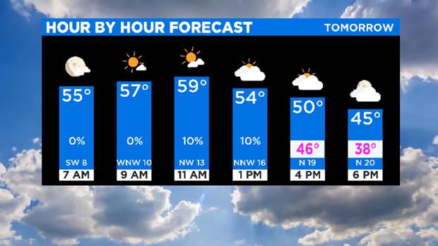
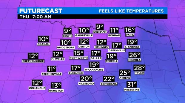
Cold air is in place on Thursday morning with temperatures in the mid 20s. Northerly winds will still be breezy, so it will feel like the 10s to start the day and we only warm into the upper 30s by afternoon.
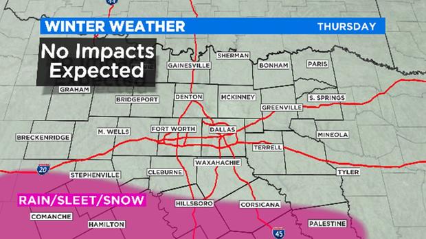
A disturbance will pass through on Thursday keeping the clouds in place over the area. South of Interstate-20 a few spots may see a mix of light rain/sleet/snow into the afternoon hours. No impacts are expected as precipitation will remain light, but we will continue to monitor the disturbance for any changes in track or strength.
The cold air sticks around a bit longer this time. Friday and Saturday mornings also start in the 20s with highs in the 40s.