Potentially historic El Niño points to warmer, drier winter for Southeast Michigan

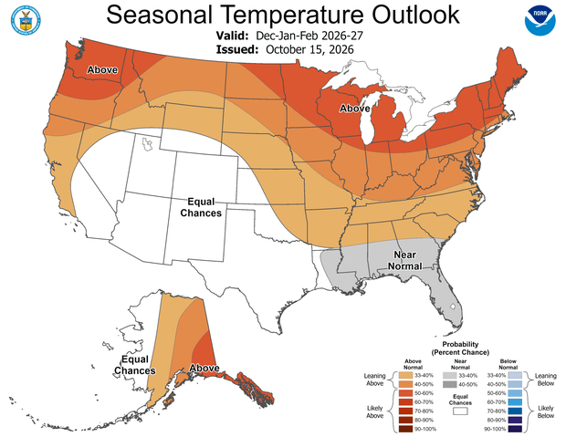
Southeast Michigan is heading into winter with strong odds favoring above-normal temperatures and below-normal precipitation, as shown in the latest official 90-day winter outlook from the National Weather Service.
The primary driver of the forecast is a powerful El Niño event anchored across the equatorial Pacific Ocean. It's nearly a 100% certainty that El Niño conditions will persist throughout meteorological winter, spanning Dec. 1, 2026, through Feb. 28, 2027.
In addition, there's a high likelihood that this could become the strongest El Niño event recorded since modern record-keeping began in 1950.
What It Means for Southeast Michigan
During a classic El Niño winter, an amplified Pacific jet stream extends across the southern tier of the United States, keeping the primary storm track suppressed to our south and directing active weather away from the Great Lakes.
For Lower Michigan, this pattern typically delivers milder temperatures and lower overall precipitation totals.
The official probabilities for the upcoming three-month period heavily reflect that pattern:
- Likely Warmer Than Normal: Michigan is in a "likely above normal" category for temperatures.
- Leaning Drier Than Normal: Precipitation chances lean slightly toward below-normal totals across lower Michigan, with reduced odds for significant storm systems.
- Lower Snow Totals Favored: Historical climate records show that strong El Niño events frequently limit overall seasonal snowfall across the region.
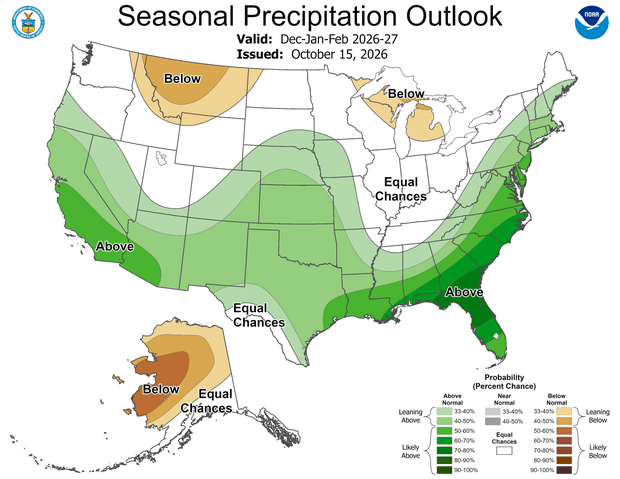
In addition to El Niño, regional climate trends over the past 15 years show a clear signal toward warmer winters across Lower Michigan.
Seasonal computer modeling from the North American Multi-Model Ensemble (NMME) also aligns with these observations, projecting elevated odds for above-average warmth across the Great Lakes basin.
History Offers Clues for Snow Lovers
Looking back at the 11 strong to very strong El Niño winters since 1950 (such as 1982–83, 1997–98, and 2015–16), local climate records show a consistent pattern:
- Temperature: Roughly 75% to 80% of past strong El Niño winters brought above-normal temperatures to Southeast Michigan.
- Snowfall: Only about 25% of past strong El Niño winters managed to produce above-normal snowfall in the area.
- The 2009–2010 Exception: At least a portion of Southeast Michigan recorded below-normal snowfall during every single strong El Niño on record, with the notable exception of the 2009–2010 winter season.
Current Drought Conditions
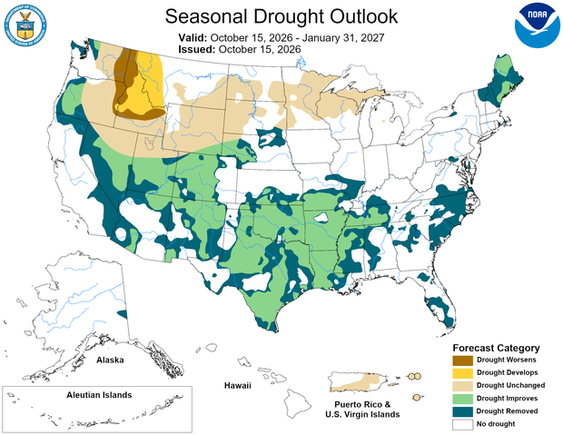
A dry late summer left much of Southeast Michigan classified as "Abnormally Dry" (D0) on the U.S. Drought Monitor, with an area of moderate drought (D1) in Mid-Michigan and widespread drought covering the Upper Peninsula and even some western areas in severe drought.
A Warmer Outlook Doesn't Mean No Winter
While seasonal outlooks highlight broader three-month trends, we want to emphasize that they do not rule out winter weather.
Atmospheric fluctuations on shorter weekly or daily scales, such as sudden stratospheric warming events, polar vortex disruptions, or shifts in the Arctic Oscillation, can temporarily override the overarching El Niño pattern.
Even during historically warm winters, intense cold snaps, lake-effect bursts, and major individual snowstorms remain entirely possible.
The bottom line is to stay up-to-date with the latest forecasts from your NEXT Weather Team as our tricky winter approaches.


