NOAA Winter Outlook for Colorado shows good snow up north
A mixed bag of winter weather is on the way for Colorado once we get to December, January and February.
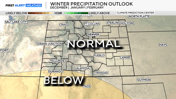
The National Oceanic and Atmospheric Administration Climate Prediction Center issues its long-range winter outlook every mid-October. This time around it looks like areas in northern Colorado may have the best chance for above-normal snow accumulations.
Climatologically, winter is a three-month period that includes December through February. The NOAA outlook takes a peek at temperature and precipitation chances over that period and whether or not they fall above or below the normal thresholds.
This outlook is based on a weak La Niña through our cold season. Which can disrupt weather patterns over the central Rockies.
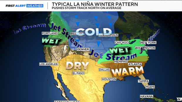
Temperature-wise, it looks like western and southern Colorado will be warmer than normal, while Denver, northern Colorado and the Eastern Plains will be be closer to normal for the three month run. This would bode well for more snow production in the northern mountains of Colorado. Which is typical in a La Niña year.

As far as precipitation is concerned, most of the state is forecast have equal chance of below or above average moisture. That would increase the odds of a normal snowfall. That being said, in a La Niña year most often the northern and central mountains would get more snow and lower levels for Denver, the Eastern Plains and southern parts of the state.
Even with that, however, there have been many years that heavy snowstorms have formed for Denver and the Front Range in a La Niña-charged year. Such was the case on March 13-14 of 2021 when Denver was buried with 27.1 inches of snow.

Another big storm in La Niña-charged year was the famous Dec. 24 storm of 1982 when 23.8 inches fell in the Mile High City.