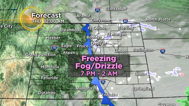
Denver Weather: Afternoon Cold Front Will Cause Fog And Freezing Drizzle
DENVER (CBS4) - A cold front in Wyoming Wednesday morning will drop south into Colorado Wednesday afternoon. Skies will become cloudy and fog and freezing drizzle will develop mainly after 7 p.m. from the Front Range to the east.
The front contains extremely shallow cold air and this is why the low clouds will only impact areas along and east of the I-25 corridor. The cold air will be too shallow to spread over the mountains or reach the Western Slope.
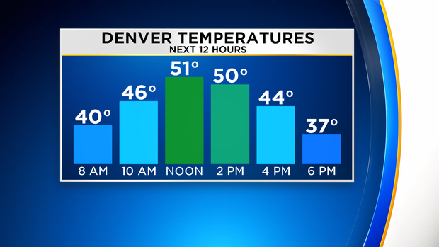
Because the front will pass the Denver metro area by early afternoon, high temperatures on Wednesday will occur around lunchtime. Most neighborhoods should reach at least 50 degrees before dropping through the 40s and falling into the 30s after 5 p.m.
While ice accumulation is always a concern when freezing drizzle occurs, the CBS4 Weather Team expects impacts to be generally minor. There are several meteorological factors working against icy roads including limited moisture, unfavorable winds for good upslope, and the relatively short period of time when the freezing drizzle is possible (about 6 hours).
That being said, there could still be a few icy patches especially on bridges and overpasses overnight but impacts to the Thursday morning should be minimal.
The freezing drizzle threat should end in the metro area no later than 2 a.m. and the clouds should clear completely before noon on Thursday. Then one more cool day will grip the Front Range before the warmest weather in weeks arrives for Friday and Saturday.