A bit more snow Saturday evening as dangerous cold moves in


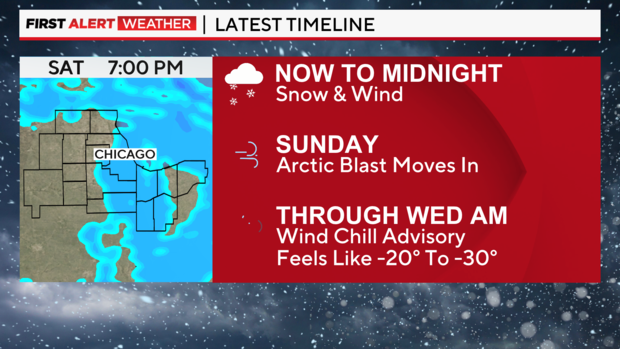
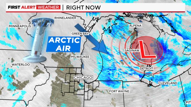
CHICAGO (CBS) -- A bit more snow is on the way for the Chicago area on Saturday evening, before an arctic blast brings in bitter cold air that will linger for several days.
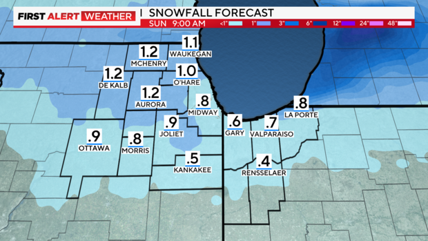
Minor amounts of snow are expected south of Interstate 80, with possibly an inch to an inch and a half northwest and north of the city. Best snow will favor the Wisconsin state line. Timing for any snow accumulation will be 6 p.m. to 2 a.m.
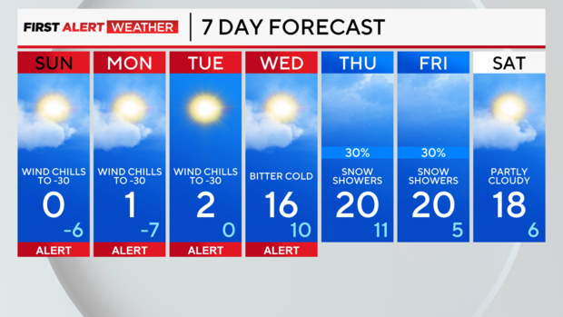
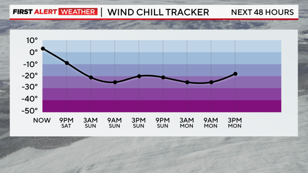
TONIGHT: SNOW & BLOWING SNOW NORTH AND WEST. LOW -5°.
SUNDAY: BITTER COLD. HIGH AROUND ZERO.
MONDAY: BITTER COLD. HIGH AROUND 1°.
The National Weather Service has issued a winter weather advisory for northern Cook County, as well as Boone, DeKalb, Kane, Lake, Lee, McHenry, Ogle, and Winnebago counties from 6 p.m. Saturday to 3 a.m. Sunday, due to blowing snow that could cause dangerous driving conditions. Snow accumulations in the winter weather advisory area could reach 1 to 2 inches.
A Wind Chill Warning has been issued for DeKalb, Ford, Grundy, Iroquois, Kankakee, Kendall, LaSalle, Lee, Livingston, Ogle, and southern Will counties from midnight Saturday night through noon Sunday, due to wind chills that could drop to as low as -35°.
Multiple Wind Chill Advisories also have been issued.
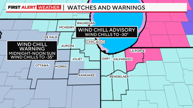
A Wind Chill Advisory has been issued for DeKalb, Grundy, Kankakee, Kendall, LaSalle, Lee, Ogle and southern Will counties from noon Sunday through 9 a.m. Wednesday.
A Wind Chill Advisory is in effect from noon Sunday through noon Monday in Ford, Iroquois, and Livingston counties.
A Wind Chill Advisory is in place from midnight Saturday night to 9 a.m. Wednesday for Boone, Cook, DuPage, Kane, Lake, McHenry, Winnebago, and northern and eastern Will Counties in Illinois; and for Lake and Porter counties in Indiana.
A Wind Chill Advisory is in effect from midnight Saturday night to noon Monday for Benton, Jasper, and Newton counties in Indiana.
For the Wind Chill Advisories, wind chills could reach as low as -30°.
Dangerous cold will settle in Saturday night through Wednesday morning, with wind chill values of -20° to -30° each morning. Some improvement will happen during the daylight hours, but even daytime temperatures will still stay in the single digits.
Temperatures briefly recover by Wednesday and Thursday as highs reach the teens. Chicago likely won't get above freezing until early next week.