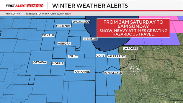
Snowstorm on Saturday could drop 10+ inches on Chicago area


A Winter Storm Watch has been issued starting Friday night for a snowstorm that could drop 10 inches or more of snow across the area this weekend.
Snow chances increase late Friday night into the early hours of Saturday. From sunrise Saturday through Saturday night, periods of heavy snow and blowing snow are likely, creating dangerous travel on roads and potential delays at airports.
Conditions begin to improve by midday Sunday, but lingering slick travel and reduced visibility will continue.
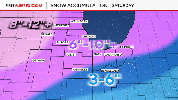
Most locations are expected to receive 6 to 10 inches of snow, with the potential for locally higher amounts exceeding 10 inches depending on the exact track of the storm.
This remains an evolving forecast, and updates/adjustments are likely as the storm approaches. Stay tuned for the latest information, and plan for significant travel impacts throughout the weekend.
This remains an evolving forecast, and updates/adjustments are likely as the storm approaches. Stay tuned for the latest information, and plan for significant travel impacts throughout the weekend.
Confidence is increasing that many areas could see more than 6 inches of snow, with isolated higher totals of 10 inches or more possible.
Snow could come down around an inch per hour.
Areas to the south could see a rain/snow mix. This will likely have an impact on totals there.
Snow pulls out Sunday and then conditions turn very cold, with lows near or below zero Sunday night and again early next week.