Severe storms cause widespread damage and outages in Chicago area


A line of severe storms triggered tornado warnings for parts of the area late Wednesday, and brought dangerous wind, hail and blinding downpours to the entire Chicago area.
The severe storms had moved on from the Chicago area by 8 p.m. But snow is on the way as the other shoe drops.
A Tornado Watch was in effect for much of the afternoon and evening Wednesday. Tornado warnings and severe thunderstorm warnings were also issued for parts of the area around the time of the evening rush.
In the wake of the storms, a rash of power outages was reported in Northwest Indiana — Porter County in particular. Widespread power outages were reported in Portage, and significant power outages were also reported in Valparaiso, to the tune of more than 470.
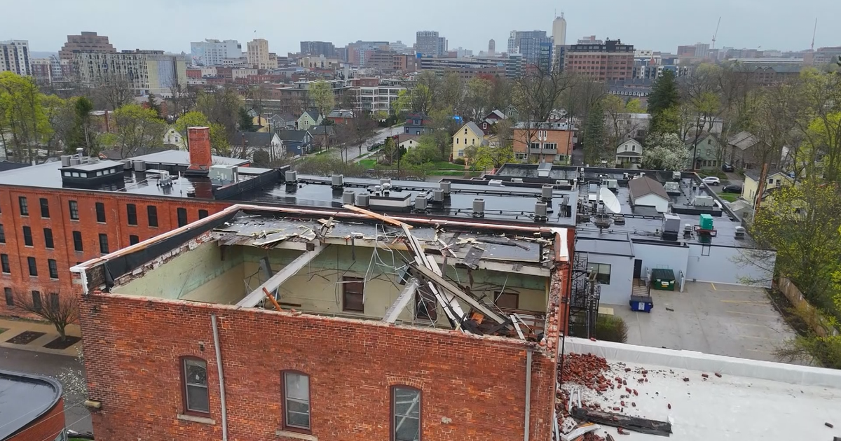
Widespread damage was also reported all around the Chicago area. Northwest Indiana was hit particularly hard.
A tornado is suspected to have been to blame for some of the damage in Gary, Indiana. On Wednesday night, the City of Gary confirmed residents spotted a funnel cloud near 21st Avenue and Hendricks Street.
Multiple homes and businesses saw significant wind damage, along with flooding and trees and limbs coming down.
At Frankie Woods McCullough Academy, a public school located at 3757 W. 21st Ave., strong winds and the possible tornado peeled back the roof of the school and damaged the gymnasium and classrooms.
The school will be closed Thursday and Friday. Spring break starts for the district next week.
Highland, Indiana was also hit especially hard by storms that blasted through the Chicago area Wednesday — with numerous trees coming down and at least one landing on a house.
On Forrest Drive in Highland, neighbors really saw the brunt of the aftermath. Two families saw trees completely uprooted on land on their lawn, and Sheila Courtright saw a tree land right on her house.
The portion of the tree that landed on Courtright's house was nearly 6 feet tall, and it was scary for her and her family — who were home at the time.
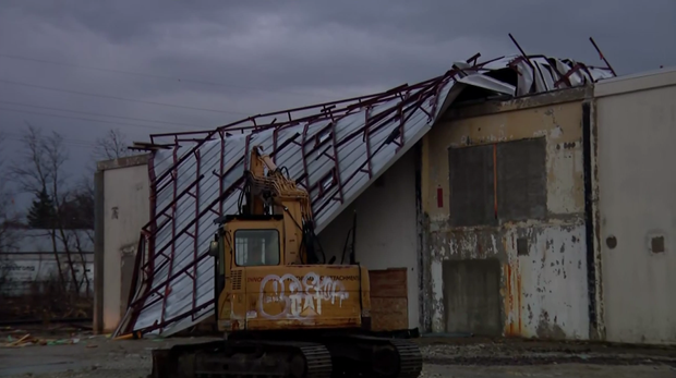
Other parts of the Chicago area also saw damage and havoc.
In south suburban Steger, Illinois, the roof was ripped off a factory building near Chicago Road and 35th Street. A neighboring gas station was also damaged, and left littered with debris from the strong winds.
In West Chicago, power poles were broken and leaning on Prince Crossing Road just south of North Avenue/Illinois Route 64.
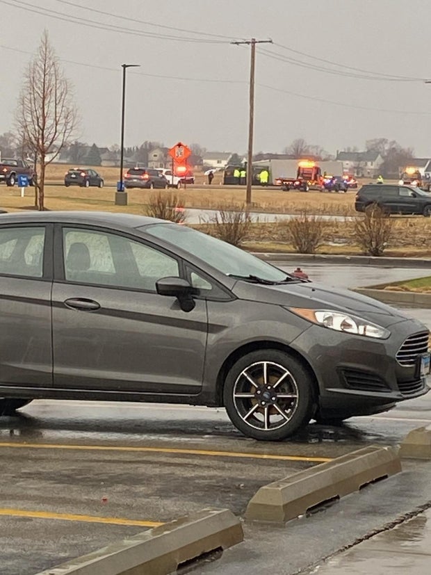
A semi-trailer truck also flipped over in south suburban New Lenox during the storms.
Chicago's Office of Emergency Management and Communications also issued a warning about hail storms on the South Side.
Earlier in the afternoon, warning sirens were heard in Kankakee, prompting CBS News Chicago's Mobile Weather Lab crew to take shelter.
No injuries were reported related to these incidents.
Chicago weather Thursday: Snow after storms
With the severe weather threat having ended across the Chicago area, attention turns to snow overnight that will make for a slippery morning commute.
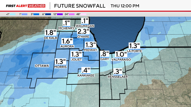
Wet snow showers will increase after midnight and become widespread overnight. Snow showers may linger through 8 a.m., especially for Northwest Indiana.
Accumulations of 1 to 2 inches will be possible, creating a messy and slick morning commute for many.
There will also be strong winds. The NWS issued a Wind Advisory for Boone, Cook, DeKalb, DuPage, Will, Kane, Kendall, Lake, McHenry, and Winnebago counties in Illinois and Lake and Porter counties in Indiana from 10 p.m. Wednesday through 7 a.m. Thursday.
There is likely to be some wind-whipped wet snow in parts of the Chicago area late Wednesday night and into Thursday morning, which could cause hazardous travel conditions.
The wintry system that is coming to Chicago slammed parts of Iowa, Nebraska, and Minnesota with snow earlier Wednesday. The snowstorm caused low visibility on roads and highways, causing dangerous conditions at times — and a slushy accumulation.
Some areas saw up to a foot of snow.
The forecast returns to more familiar seasonal temperatures Friday and Saturday.
Watch vs. Warning: What to know for thunderstorms, tornadoes
Severe storms can bring cascades of watches and warnings from the National Weather Center, as the ones on Wednesday did too. But what is the difference?
A watch is usually issued by the National Oceanic and Atmospheric Administration's Storm Prediction Center, or SPC, hours ahead of a storm system. It indicates that conditions are favorable for a type of weather, be it a thunderstorm or tornado. It gives you warning that you should be prepared to act quickly if that weather does materialize. Watches are also often applied in larger areas, encompassing multiple counties or whole states.
A warning is more urgent and calls for action to be taken immediately. It is issued by the nearest National Weather Service office when a severe weather event like a tornado has been spotted on the ground or indicated by radar. Warnings cover a much smaller area, like a city or a single county.
If you are under a severe weather warning, take steps to keep yourself and your loved ones safe immediately.
What to do in an event of a tornado warning
If a tornado warning is issued for your city or county, you should go immediately to a room on the lowest level of your home, like a basement, storm shelter, or interior room. If you don't have a basement, go to an interior room with no windows like a bathroom on the lowest level of your home. Stay away from windows and, if possible, bring your pets with you.
Make sure you have water, a flashlight, your phone or a radio to receive alerts, and any charging devices you may need. Wait for the warning to end and the storm to pass before going outside.
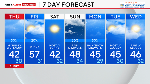
Full 7-day Forecast for Chicago area
Snow swings into the area early Thursday for the first day of spring. Travel will likely be messy and slow for the early morning rush. Minor accumulations of a half-inch to 2 inches of snow are possible. Once the snow ends just after daybreak, the skies clear for sunshine.
Temperatures moderate back to near 60 degrees for Friday. Shower chances increase at night into Saturday morning. Another round of rain showers develops late Sunday into Monday.