Potentially historic El Niño has developed; could bring stormy summer, warmer winter to Chicago area

A potentially historic El Niño pattern is no longer just brewing in the Eastern Pacific – it is here.
NOAA's Climate Prediction Center has issued an El Niño Advisory, meaning El Niño conditions are officially present in the tropical Pacific Ocean. Water temperatures in the central and eastern Pacific near the Equator have warmed significantly since May, and the atmosphere is now responding with enhanced thunderstorm activity in that area and altered global weather patterns — a key step in the development of a true El Niño pattern.
The El Niño-Southern Oscillation, or ENSO, is a natural cycle that causes water temperatures in the eastern Pacific Ocean near the Equator to fluctuate every two to seven years. Warmer than normal water in that area is called an El Niño pattern, and cooler than normal water is known as a La Niña.
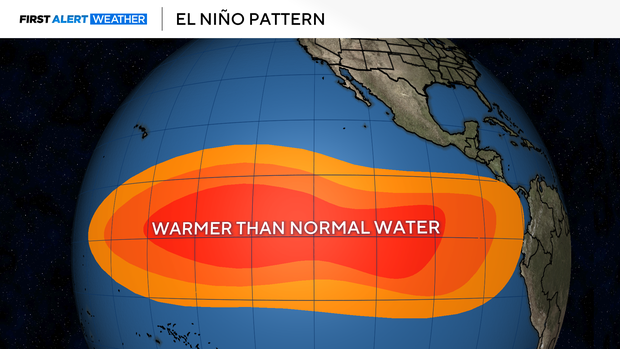
This cycle disrupts weather patterns globally, including in Chicago. While El Niño can bring a cooler, stormier than normal summer to the Great Lakes, its strongest impacts are usually felt during winter as the pattern peaks. El Niño winters in Chicagoland are typically warmer than normal with below-average snowfall as the polar jet stream shifts farther north into Canada.
This year, Illinois has already seen a very active severe weather season, leading the nation in tornado count so far in 2026. A developing El Niño can help tilt the broader pattern toward more active storm tracks across parts of the central and eastern U.S.
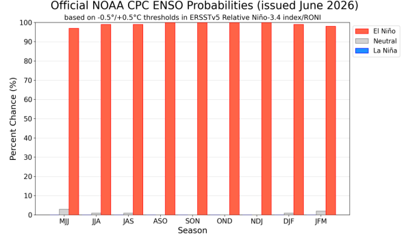
And the odds of a potentially record-strong El Niño are now even higher. NOAA now gives this El Niño a 63% chance of reaching the "very strong" threshold between November 2026 and January 2027. There is a near-90% chance it peaks as either a strong or very strong event this winter – up from a 67% chance in May.
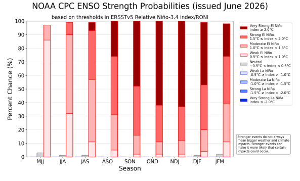
An El Niño's strength is measured by how much eastern Pacific water temperatures rise above their normal levels. A very strong El Niño means water temperatures in the Niño 3.4 region of the tropical Pacific are at least 2°C (3.6°F) above average.
The latest ensemble model guidance shows a potential peak of roughly 2.0°C to 2.3°C (3.6°F to 4.1°F) this fall or winter. Some individual model runs suggest even higher anomalies are possible, which could mean a record-setting event.
The three most recent "very strong" El Niño events have led to wintertime temperatures running an enormous 4° fever in Chicago, and less than half of the city's typical snowfall between December and February. A warm 2026-27 winter locally could mean lower heating bills, less snow shoveling, and fewer days of hat and scarf weather.
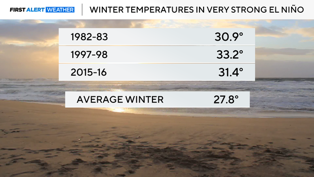
But it does not mean Chicago gets to skip winter. Even warm El Niño winters can still bring occasional Arctic outbreaks and snowstorms. Strong El Niño patterns simply tilt the odds toward a warmer, less snowy winter overall. And while the strength of an El Niño makes impacts to our local weather more likely, it does not necessarily increase the magnitude of those impacts.
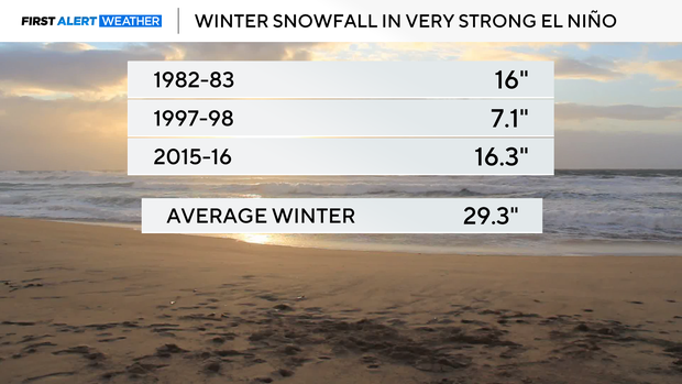
This El Niño is developing on top of an already overheated global ocean system.
Global sea surface temperatures reached record levels for the time of year in late June, according to Europe's Copernicus Climate Change Service. Copernicus says the new ocean temperature records are consistent with the onset of El Niño, combined with unusually warm water already observed across most global ocean basins.
That matters because significant El Niño patterns tend to raise global temperatures by releasing extra ocean heat into the atmosphere. With global ocean temperatures already at record-warm levels, a strengthening El Niño will add even more heat to the climate system in the months ahead, raising the odds of additional temperature records.
Recent deadly heat waves in Europe and the U.S. cannot be blamed on El Niño alone, but the strengthening El Niño likely added extra background warmth to an atmosphere already warmed by climate change, potentially making those heat extremes even more intense.
El Niño also tends to increase disruptive wind shear over the tropical Atlantic, often suppressing hurricane activity during the summer and fall months. But with Atlantic Ocean temperatures also running unusually warm, forecasters will be watching closely to see whether El Niño's suppressing influence can overcome the extra fuel available from warm ocean water.
On Wednesday, Colorado State University forecasters reduced their 2026 Atlantic hurricane season outlook to just 9 named storms, 4 of which become hurricanes and one a major hurricane – far below the long-term averages of 14 named storms, 7 hurricanes and 3 major hurricanes.


