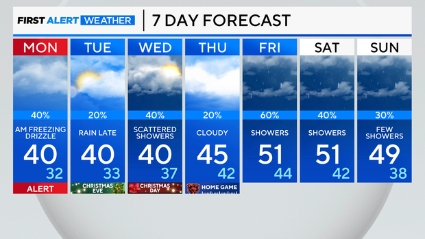
Freezing drizzle chances overnight turning to a mild Christmas week

CHICAGO (CBS) — As a weather system moves closer to the Great Lakes area, drizzle will start to develop in Chicago late overnight—which could result in freezing drizzle as temperatures drop below freezing through the early morning hours.
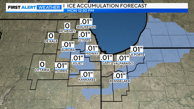
Untreated roads and surfaces could ice up rather quickly as the pockets of drizzle and rain freeze on contact with cold surfaces.
Ice patches will be possible until daybreak Monday, and thus, everyone make sure to plan accordingly if traveling.
Due to the ice glaze threat early Monday morning, the CBS News Chicago First Alert weather team has declared tomorrow a First Alert weather day to provide a heads-up on the possibility of tricky travel.
As temperatures warm towards 40 degrees by midday, rain showers will be scattered throughout the area.
Drier conditions are expected for Monday night.
On Tuesday night and into Wednesday morning, another system is expected to graze Northeast Illinois and Northwest Indiana, so rain showers could greet us on Christmas morning.
Through the entire holiday week, temperatures will be mild in the 40s to 50 degrees.
Forecast at a glance
Sunday night: Areas of drizzle & freezing drizzle. Low of 30.
Monday: Drizzle and rain in the morning. Ice patches possible. On and off rain showers during the afternoon. High of 40.
Monday night: Drying out, cloudy. Low of 32.