Destructive storms hit Chicago area with wind gusts over 90mph; 3 tornadoes confirmed and flooding









Tornadoes were reported touching down in Chicago's south suburbs and in Northwest Indiana as a line of destructive thunderstorms barreled through the area Tuesday morning.
The National Weather Service confirmed at least three tornadoes touched down in the south suburbs.
One confirmed tornado touched down in eastern Will County near Monee and Crete. The damage was consistent with an EF-1 tornado. Another confirmed tornado touched down in southern Cook County near southern Oak Forest and Flossmoor. The damage was consistent with an EF-1 or stronger tornado. The third tornado occurred in Northeast Will County, which includes the Mokena area, with damage consistent with EF1.
Part of the Indiana Toll Road at mile marker 17.5 was closed in both directions because of power lines across both directions of travel. Indiana State Police said multiple semis rolled over on southbound I-65 at US 30 after having pulled over for safety during the severe weather.
The radar-confirmed tornado in the south suburbs was believed to be at least an EF-2, based on the wind speeds picked up by the Doppler. The tornado was also rain-wrapped and could not be easily seen.
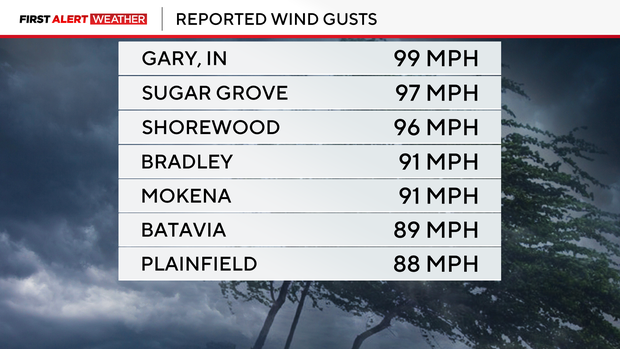
Hurricane-force winds were reported throughout the area, with the strongest gust reported in Gary, Indiana, at 99 miles per hour. In Sugar Grove, Illinois, a gust of 97 mph was reported, while in Shorewood, they reported winds as high as 96 mph.
Tornado sirens wailed in Aurora and Plainfield around 10:15 a.m., and by 10:45 a.m. they were heard in the city of Chicago.
Multiple tornado and severe thunderstorm warnings and watches issued during the storms have since expired.
Ground stops that had been issued earlier for both O'Hare and Midway airports have since expired.
ComEd is reporting power outages affecting more than 234,000 of its more than 4.1 million customers in Northern Illinois and NIPSCO is reporting power outages affecting more than 300,000 of its approximately 500,000 customers in Northwest Indiana as of 5 p.m.
Downed trees, power lines, and flooding among storm damage reports
Reports of widespread damage began as the storms quickly moved through and out of the area. The hardest-hit areas were the south and southwest suburbs and Northwest Indiana, but the line of storms stretched north to south across the entire Chicagoland area.
In Tinley Park, the Credit Union 1 Amphitheater was damaged in the storms, with debris left all over the field where concertgoers camp out, and damage to the roof of the concert pavilion.
At a nearby subdivision near 183rd Street and Oak Park Avenue, multiple homes were also damaged by the storm.
Strong winds ripped parts of the roof off of Kerry Hourigan's house. Neighbors described what came through as a tornado.
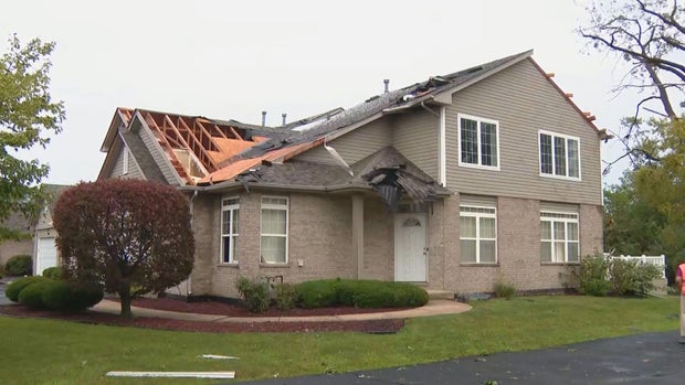
Hourigan was fortunately not home at the time the storm hit. Her homeowners' association alerted her of the damage.
"The laundry room door is totally at the other side of the kitchen. Windows are all out, totally. The back upstairs bedroom windows, the lower partial window is out, most of the windows are broken. The garage door is all bent up," Kerry Hourigan said. "You can basically see where it went through. Straight through the middle, that's what it looks like."
CBS News Chicago meteorologists said winds as strong as 126 mph struck Tinley Park, although it has yet to be confirmed if it was a tornado or straight-line winds.
In Oswego, a live downed power line sparked a fire in the grass next to Grove Road south of Collins Road.
The high winds downed massive trees and branches throughout the area, blocking the 8900 block of S. Phillips in Chicago's Calumet Heights neighborhood. In Lansing and in Orland Park, enormous trees were toppled from the roots and branches and debris blocked roads.
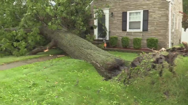
In Lansing, winds of more than 100 mph knocked down trees, power lines, and street signs. Many streets were left impassable.
Residents said they had recently finished cleaning up from tornado damage a couple weeks ago they just finished cleaning that mess up.
Isabel Mobley said she's grateful the tree that punctured her roof didn't do more damage to the inside of her home.
"To see this, it was a little scary, devastating. I got two cats. I was hoping they were safe. Everything's fine, damage wasn't too bad inside. So, it's not like I came into damaged furniture or anything like that. It was mainly in the crawlspace. So, hopefully this situation gets taken care of," she said.
People with damage to their homes in Lansing were waiting for crews to arrive with tarps since more rain is on the way over the next several days.
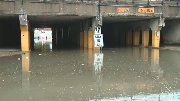
In Homewood, a viaduct was flooded so completely that the water nearly reached the "Stay In Lane" sign near the top of the tunnel.
In Highland, Indiana, trees tore into the roofs of homes and limbs littered the streets.
The storm also knocked down multiple trees in nearby Hammond, where roads have been blocked off to keep people safe from downed power lines.
"The wind was bad. I believe it was 80 miles an hour," said Hammond resident Luiz Valdez.
Valdez said he has no idea how long his power will be out, only that a gigantic tree knocked down the power lines that give electricity to his home and into the rest of his neighborhood.
"I can do nothing, just wait; wait and pray, you know, that God give mercy with Indiana," he said.
In Glenwood, a massive tree toppled over and destroyed a home during the storms. Thankfully, no one was home at the time.
Calling it a scene out of a movie, Joe and Tai Coe were left stunned by what they saw.
"It's shocking just to see all these back-to-back rain storms and things like that. So I just thought it would never happen to us," Joe said.
However, they remain optimistic but will keep the damage in mind when buying their next home.
"It happens, you know, we got to move forward and get through it," Joe said.
In Flossmoor's Baythorne subdivision, trees also knocked out the power. Ron Lynch said he didn't see things happening, but heard it when the storm rolled through.
Northwest Indiana has been hit multiple times by tornadoes and other severe storms this summer.
In addition to the homes damaged on Tuesday, a semi-trailer also toppled over in Hammond because of the sheer force of the winds.
Bret Roberts was among the many people spending their day helping clean up debris from the storms.
"We feel like everybody needs to help. That's the point of life. So I got sent home early from rain out, so there's nothing better to do than just to help out," he said.
Storm activity decreased throughout the day, but the overall weather pattern remains active, with additional chances for thunderstorms continuing through the end of the week and into the weekend.
Meanwhile, ComEd officials say their crews and equipment were positioned in strategic locations to help with response times in the aftermath of the storm. They say that Tuesday's event was the 19th major weather event so far this year — the highest in two decades.
ComEd officials say more outages are expected with additional storms on the way this week. They have 1500 utility personnel from other states on their way to help
As of Tuesday night, over 270,000 people remain without power. They're hoping by midnight on Saturday everyone's power will be restored.


