Chicago Weather: Snow Pounds Chicago Area; Lake Enhancement Could Bring 6 Inches Or More For Some Areas
By Albert Ramon and Robb Ellis
CHICAGO (CBS) -- Snow began pounding the Chicago area Saturday afternoon, and the forecast continues to call for up to 6 inches or more of accumulation in some areas.
The National Weather Service has issued a winter storm warning for Cook, DuPage, and Lake counties in Illinois and Lake and Porter counties in Indiana until 6 a.m. Sunday; and in DeKalb, Kane, Kendall, LaSalle, and McHenry counties, and part of Will County, through midnight Saturday night.
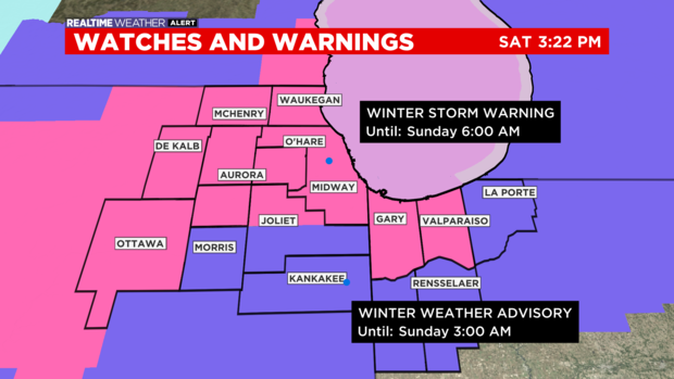
Other parts of the area are under a winter weather advisory, which has been extended to 3 a.m. for Kendall and Will counties.
As of 6 p.m., widespread snow was on the weather radar – with the heaviest falling over central sections of Cook County. Winds were also howling – up to 33 mph at Midway International Airport, and 21 mph in Waukegan. Visibility was greatly reduced – down to 0.8 mile at O'Hare International Airport, Aurora, and McHenry.
Conditions will worsen as the evening goes on, especially for those right along the lakefront, CBS 2 Chief Meteorologist Albert Ramon reported.
Lake enhancement began kicking up in southern parts of Cook County by 6 p.m.
CBS 2 Meteorologist Robb Ellis noted the overall larger weather system was set to wrap up around midnight. But the lake enhancement will be dominant overnight, and in Northwest Indiana on Sunday morning.
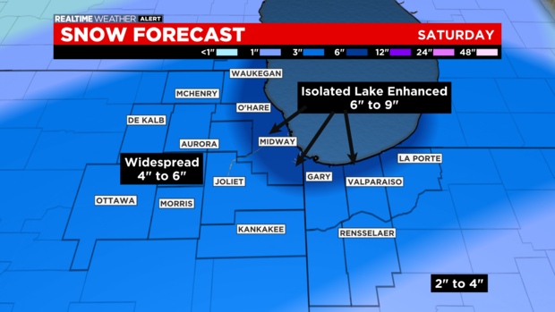
Forecast snow totals have been revised down to a degree. Most of the area will likely see 3 to 6 inches, with 1 to 3 inches to the south. But along the lakefront, 6 inches or more are expected – and some areas could still see 9 or even 10 inches.
At 8 p.m., a moderate burst of snow developed over Cook, DuPage, and Will counties thanks to that lake enhancement. We expect this trend to continue through the evening.
Snowfall amounts as of 8 p.m. were ranging between 1.4 inches at O'Hare to 4.7 inches in Greenwood.
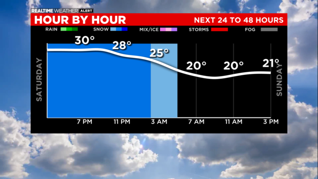
When temperatures drop overnight, some blowing snow is possible.
The Chicago Department of Streets and Sanitation has placed 287 salt spreaders on the roads throughout the night and into Sunday morning.
The salt spreaders will focus on Chicago's main roads and DuSable Lake Shore Drive as they plow snow and clear ice.
The snow tapers off overnight, except for lake effect snow. Lows drop into the 20s.
On Sunday morning, a few lake effect snow bands will persist in Northwest Indiana. Otherwise, there will be some clearing.
It will be clearing and colder Sunday afternoon.
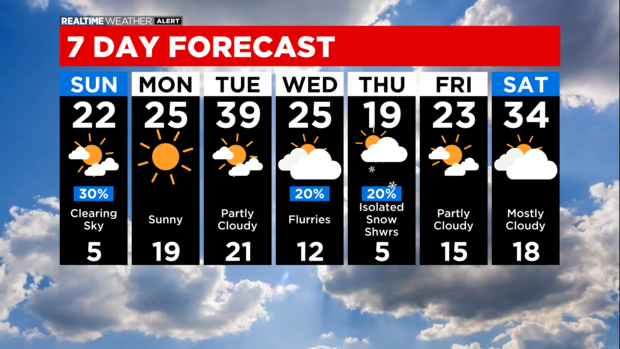
Cold temperatures are expected Monday morning with lows in the single digits and wind chills likely below zero. It will be warming up quickly by midweek.


