Chicago Weather: Tracking first accumulating snow of season
The first accumulating snow of the season has arrived.
By the end of the day on Wednesday, some towns to the north could get four or five inches.
After the snow, temperatures drop near freezing.
Lake effect snow in Michigan City
How much snow do you see?
It depends on where you live!
Heavy lake effect snow was falling Wednesday afternoon in Michigan City, creating slick roads and slower driving.
Radar and temperatures as of 3:45 p.m.
Check the latest conditions on our CBS 2 Chicago WEATHER PAGE.
Here is the current situation as of 11 a.m.


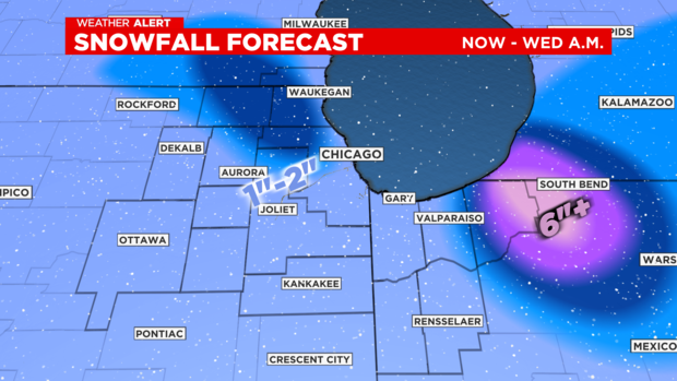
Snow moving south, heavy lake effect expected in NW Indiana
A ragged snow batch across northern Illinois will continue to drag south this afternoon, CBS 2's Mary Kay Kleist reports. Poor visibility and minor grassy accumulation possible as this drifts south.


Snow showers taper off with sunset.
There is a winter weather advisory for Porter County until 7 p.m. for heavy lake effect snow bands of 1" to 2" per hour.
Motorist can expect hazardous travel near the Indiana-Michigan border
Another disturbance will bring scattered snow showers and flurries tomorrow, but moisture with this system will be limited.
Radar and temperature as of 11 a.m.
Check the latest conditions on our CBS 2 Chicago WEATHER PAGE.
Here is the current situation as of 11 a.m.


Winter weather advisory for Porter County, Indiana
The National Weather Service has issued a winter weather advisory for Porter County, Indiana, from 1 p.m. to 7 p.m. on Wednesday.
"A period of heavy, wet, wind-driven snow with rapidly fluctuating visibilities is expected. Snowfall rates of up to 1 to 2 inches per hour are expected to lead to sharp visibility reductions and snow covered roads," the National Weather Service said.
Drivers should expect sharply reduced visibility and slippery road conditions that could affect the evening commute, including along Interstate 80/90 and Interstate 94.
Official snow totals from Tuesday
The official snowfall at O'Hare International Airport was one inch on Tuesday, making it the first day of accumulating snow so far this season.
The average date for at least a one-inch snowfall is Dec. 7, according to the National Weather Service.
Totals elsewhere:
Austin neighborhood -- 1.4 inches
Rockford -- 1.3 inches
Midway Airport -- 0.7 inches
Joliet -- 1.9 inches
Snowy conditions in McHenry County
In downtown Chicago, the roads are just went with now snow. The situation is quite different in McHenry County.
Here is a photo from the National Weather Service:
Radar and temperatures as of 8 a.m.
Check the latest conditions on our CBS 2 Chicago WEATHER PAGE.
Here is the current situation as of 8 a.m.


Chicago Weather Alert: More snow ahead Wednesday
Roadways should be clear for Wednesday morning commuters as only minor accumulation is expected.
Evening commuters may be impacted by slow driving conditions with bursts of snow expected.
Wednesday's high temperatures will be in the mid 30s, but an arctic chill settles in by the end of the week.

An arctic chill settles in by the end of the week. Highs both Friday and Saturday will be in the 20s and lows in the teens.
What to expect on Wednesday
Isolated snow showers are expected for the morning commute Wednesday. Slick spots are possible from the snow on Tuesday evening, but no widespread issues expected.
A rain/snow mix is in store for the afternoon commute Wednesday, with slick Spots and reduced visibility issues.
La Porte County, Indiana remains under a Winter Storm Warning Wednesday for the threat of heavy lake effect snow.
4:30 a.m. to 7 a.m.: Models have backed off on widespread snow showers for much of the morning rush hour. A few areas of wet snow will still be possible, especially along the Northshore & Lake County IL.
7 a.m. to 11 a.m.: Increasing scattered rain/snow/sleet mix.
11 a.m. to 5 p.m.: More widespread snow/rain mix. Some slushy accumulation possible that could trigger travel issues.
6 p.m. to 10 p.m.: Snow showers end, move south.
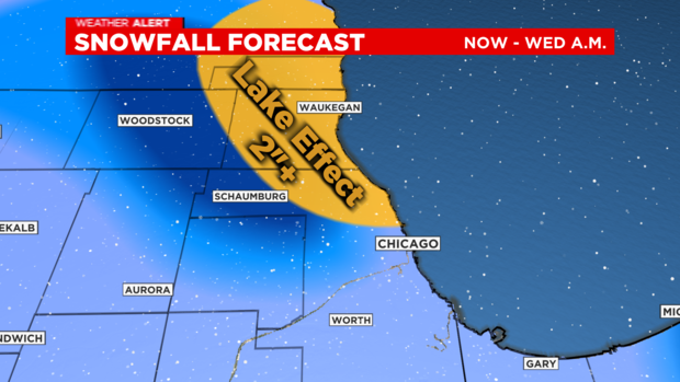
Snow picks up on North Shore as temps fall
Around 6 p.m., moderate snow began picking up along the North Shore – from the Edgewater neighborhood up through Evanston, Highland Park, and Waukegan.
Temperatures were dropping close to freezing from Skokie northward and some snow was sticking in those areas, though not on roadways.
The best chance of accumulating snow is during the evening through 10 p.m.
Scattered areas of wet snow will remain in the forecast tonight through the day on Wednesday. Additional snowfall amounts will average between 1 to 2 inches, but some isolated higher amounts will be possible.
Two inches, or more, is possible from North Shore to the Wisconsin line due to a lake effect snow burst on Wednesday afternoon.
Temperatures and radar as of 5 p.m.
Check the latest conditions on our CBS 2 Chicago WEATHER PAGE.
Here is the current situation as of 5 p.m.


Chicago Weather Alert: Winter Weather Advisory continues in Lake County
A Winter Weather Advisory continues for Lake County.
The National Weather Service cancelled its advisory Monday afternoon for much of the Chicago region including Cook, DeKalb, DuPage, Kane, Kendall, McHenry, and Will counties.
So far today, the highest snow amounts have been 3.5 inches.

For the rest of the afternoon, we expect rain to mix with snow showers as temperatures hover above freezing.
For the latest update from Meteorologist Mary Kay Kleist, click here.
Temperatures and radar as of 2 p.m.
Check the latest conditions on our CBS 2 Chicago WEATHER PAGE.
Here is the current situation as of 2 p.m.


Winter Storm Warning for LaPorte County, Indiana
The National Weather Service has issued a winter storm warning for LaPorte County, Indiana, from 3 a.m. Wednesday to 9 a.m. Thursday.
Heavy, wet lake effect snow could bring 5-10 inches of accumulation, with amounts of around 1 foot possible along the Indiana-Michigan state line.
Travel likely will be very difficult Wednesday morning into Thursday morning, with hazardous conditions for the morning and evening commutes.
If you must travel, keep an extra flashlight, food, and water in your vehicle in case of an emergency.
Temperatures and radar as of noon
Check the latest conditions on our CBS 2 Chicago WEATHER PAGE.
Here is the current situation as of noon.


Chicago Weather Alert: More snow ahead
CBS 2's Mugo Odigwe reported live from the South Loop where there is light falling snow.
She said the roads are wet, but there is little mid-day accumulation.
While snow is minimal, Odigwe said residents woke up to snow accumulation on grassy areas and cars. Neighbors told her they were not phased by the snow.
Resident Becky Delatorre said it's "not a big deal."
Odigwe is warning drivers heading onto the roadways to be careful. Evening commuters should be aware of slick driving conditions caused by continuing snowfall.
A friendly reminder: How to drive in show
You know it happens every year: Drivers always forget how to drive in the snow.
Police report more spinouts as cars slip and slide on glazed roads. So, while it may seem silly, here is an annual public service: Driving In Snow 101 (Source: AAA)
- Drive slowly. Always adjust your speed down to account for lower traction when driving on snow or ice.
- Accelerate and decelerate slowly. Apply the gas slowly to regain traction and avoid skids. Don't try to get moving in a hurry and take time to slow down for a stoplight. Remember: It takes longer to slow down on icy roads.
- Increase your following distance to five to six seconds. This increased margin of safety will provide the longer distance needed if you have to stop.
- Know your brakes. Keep the heel of your foot on the floor and use the ball of your foot to apply firm, steady pressure on the brake pedal.
- Don't stop if you can avoid it. There's a big difference in the amount of inertia it takes to start moving from a full stop versus how much it takes to get moving while still rolling. If you can slow down enough to keep rolling until a traffic light changes, do it.
- Don't power up hills. Applying extra gas on snow-covered roads will just make your wheels spin. Try to get a little inertia going before you reach the hill and let that inertia carry you to the top. As you reach the crest of the hill, reduce your speed and proceed downhill slowly.
Video of early morning snow
Snow totals ... so far
Here are area snow totals, reported at 7 a.m. on Tuesday:
COOK
La Grange Park 2.7 inches
Forest Park 1.5 inches
Palatine 1.5 inches
Elk Grove Village 1.1 inches
Schaumburg 2.9 inches
Hoffman Estates 1.0 inch
Oak Park 1.0 inch
Homewood 1.0 inch
Mount Prospect 1.0 inch
Elk Grove Village 0.9 inch
Schaumburg 0.9 inch
Harwood Heights 0.9 inch
Oak Forest 0.8 inch
O'Hare Airport 0.6 inch (official)
Palos Park 0.5 inch
Chicago Ridge 0.5 inch
Midway 0.4 inch
DE KALB
DeKalb 1.9 inch
Malta 1.8 inch
Cortland 1.4 inch
Genoa 1.2 inch
DU PAGE
Downers Grove 3.1 inches
Aurora 3.0 inches
Clarendon Hills 3.0 inches
Morton Arboretum 2.4 inches
Woodridge 2.3 inches
Bolingbrook 2.2 inches
Elmhurst 2.1 inches
Darien 2.1 inches
Villa Park 2.0 inches
Elmhurst 2.0 inches
Naperville 1.5 inches
Glen Ellyn 1.0 inch
Bloomingdale 1.0 inch
LAKE
Bannockburn 1.2 inches
Mundelein 1.1 inches
Wadsworth 1.4 inches
Buffalo Grove 0.5 inches
WILL
Plainfield 3.5 inches
Naperville 3.5 inches
Bolingbrook 2.8 inches
Joliet 1.2 inches
When is it normal to get an inch of snow?
Tuesday, Chicago can expect its first snowfall of more than an inch for the season.
Is this normal?
According to the National Weather service, the record for the earliest snow of an inch or more happened on October 19, 1989.
The "normal' first date is Dec. 7, so we are a few weeks early this year.
In 2013, Chicago didn't have an inch of snow until Jan. 25!
Get ready for winter with Kris Habermehl
Chicago Weather Alert: Wet roadways, snow plows deployed
CBS 2's Mugo Odigwe was out in the Mobile Weather Lab heading toward the Chicago suburbs. She said the snow was coming down and causing wet roadways early Tuesday morning. Odigwe said while the roadways are wet, she has not seen much accumulation.
Mid morning, Odigwe reported snow tapering off. She said wet roads are still causing issues on the roadways.


