Winter Weather Forecast: Below Average Snowfall, Warmer Than Average Temperatures, WBZ-TV Weather Team Predicts
BOSTON (CBS) - Let's be real - a winter outlook is an educated guess about future events months in advance. A lot can go wrong. The temperature tea leaves are a little easier to read, but in the snowfall department just one or two big events can greatly influence an entire season. Even years when we think the outlook is doing well (like 2017-18) a month like March can blow it all up. That entire winter went in perfect lockstep with our preseason ideas, until 2-to-3 feet of snow fell at the very end!
Sometimes I marvel at the extremes. We can have intense runs like in 2015 where the storms are lined up on approach to Logan Airport and ready to pummel us with precision. On the flip side, it's remarkable that we can go October through May with under 10 inches of snow. Feels like that should be impossible around here, but it has happened. There are a lot more winters in the record books with under 30" of snow in Boston than there are winters with over 60"!
Sure, we could just sit on the sidelines and watch it all unfold, but what's the fun in that? Nature always gives us some clues to attempt solving a complex puzzle.
Let's look at which pieces are on the table this time around.
PACIFIC OCEAN
The first place we look to figure out the atmosphere is down, not up! Oceans give us a great starting point, and in particular the Pacific. It covers 30% of Earth's surface and influences patterns across the globe.

For the second year in a row La Nina is in charge, meaning a large patch of cooler than average water near the equator. La Nina is less straightforward than El Nino, which features a warmer equatorial Pacific. El Nino winters often follow their script with a mild December and colder conditions/bigger storms toward January and February. La Nina winters are much more variable, making them trickier to pin down. We've had a wide range of outcomes based on how intense a La Nina event is, where the core of it is located, and how it's interacting with other things in the atmosphere.
There's a very noticeable lack of the "warm blob" south of Alaska that's been dominant during the past decade. Instead, this region is cooler than average and takes on a pattern we call the negative phase of the Pacific Decadal Oscillation (-PDO).
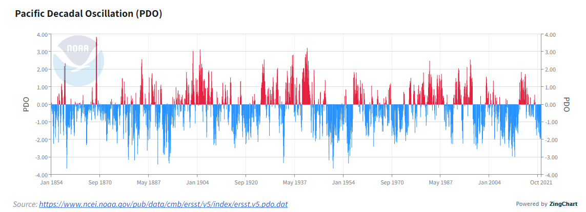
We haven't had one like this since 2011, which is a very good match in the Pacific to what we currently have.
SIBERIA SNOW
Another interesting element to look at is how quickly snow advances across Siberia during October. The theory goes that a larger and faster extent can help lead to a destabilized polar vortex, increasing the risk for cold and snow here. This October, there wasn't much of a rapid push. The same goes for North America.

Both, like the Pacific, are very similar to 2011 as the most recent match.
POLAR VORTEX
What about that polar vortex anyway? It's become part of pop culture to describe anything cold, but here's the deal. A weak vortex allows more arctic air and stormy patterns to develop where we live. A strong one keeps the arctic outbreaks at bay. Unfortunately, it is something that cannot be well predicted more than a couple weeks in advance, though La Nina does produce more big disruptions than other years. What we can say for now is that guidance is leaning toward a strong vortex through at least early December.
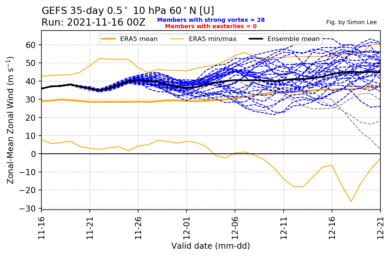
Another important note on the polar vortex is that it is like watching paint dry. We're used to getting things quickly these days, but you have to pack some serious patience with the PV. We might spot a disruption or split a couple weeks in advance. Then, the process must occur. And then it's usually several more weeks before anything happens here, if at all. Bottom line is that a significant disruption early in the season would point to some front-loaded cold outbreaks, but a stronger vortex and milder conditions later in winter. If one occurs more toward mid-January or February, then you're in trouble toward early spring. The way things are starting, that second path looks more likely than the former.
THE WINTER FORECAST
This winter, I feel like we're walking through one of two doors. Door #1 is 2011-12, which was exceptionally mild and snowless. We've shared a lot of characteristics with 2011 all year. A hot, wet summer. Tropical troubles. A very warm fall. A big late October storm. There were only 9.3 inches of snow that entire winter. This is the most negative PDO since then, 2nd year of a Nina like that winter was, etc. North American snow extent during October was the lowest since 2011, and nearly the same (2nd to 2019, another quiet winter) over Siberia. The list of comparisons is long.
Door #2 is a winter like 2017-18. It was also a warm fall and the 2nd year of La Nina. It did not feature as much of a -PDO setup and had a more glaring east-based La Nina that was really hugging the South America coastline. That location is more likely to produce cold here, and we did get a major plunge of frigid air late December through early January, though it balanced out with a surge of warmth later in January through February.
I really think it all comes down to polar vortex behavior. It's the biggest difference between 2011 and 2017. The 2011-12 winter had a very strong PV most of the season. The 2017-18 winter had a major SSW/split which delivered huge snow in March, bringing the season above average - 59.9 inches fell that winter - and a bitter start to spring.
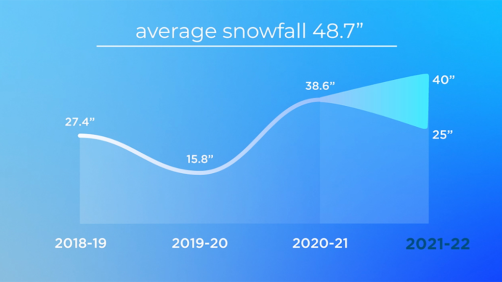
I'm inclined to lean more toward the quieter winter of 2011. It seems like a better match of all variables. But it's tough to just say "total dud winter incoming" and then there's one big storm in December and it all goes down the drain. So we'll bring in the old Las Vegas house hedge and split the difference. Let's call for 25-40" of snow for the winter season in Boston, (the average is 48.7 inches) with more across central Massachusetts and less across the South Coast and Cape.
When it comes to temperatures, I generally start with warmer than average and then look for reasons why it won't be. The new 30-year averages were released earlier this year, and winter had warmed faster than any other season.
We saw some flashing signs in 2013 and again in 2014, called for colder than average conditions those two winters, and they verified. But as the climate warms, we're undeniably seeing less consistent harsh cold. Every winter since 2014-15 has been warmer than average, and during those six years we had the warmest winter, the warmest December (2015), warmest February (2018), plus the warmest overall January (2020) and February (2017) days on record in Boston. We've had temperatures in the 70s five times over the past four winters.
More importantly, the nights have gotten considerably milder. 150 years ago, Boston saw 40 nights per winter below 20 degrees. Today, it's half that. So bottom line is that we'll go for a warmer than average winter, with the best shot at a colder than average month coming in December.


