Snow, rain, sleet all part of long duration storm forecast across Massachusetts Wednesday into Thursday
A storm is heading to the Boston area and it will bring rain, wind and some snow to parts of Massachusetts Wednesday into Thursday. Here's the latest forecast from the WBZ NEXT Weather Team.
BOSTON - A highly disruptive, long-duration storm system will bring a wide variety of precipitation types and impacts. Or, put simply, the next few days will be a miserable mess!
Winter Storm Warning
The National Weather Service has issued a winter storm warning for northern Worcester County and extreme northwestern Middlesex County for Wednesday and Thursday.
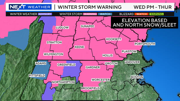
There are now winter storm warnings posted for all of southern Vermont, New Hampshire and Maine. These areas have a much higher risk of more significant snow accumulation.
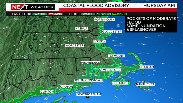
In addition, the NWS has issued a coastal flood advisory for the Thursday morning high tide cycle.
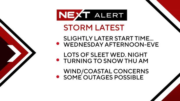
When does the storm arrive?
Most of Wednesday morning will likely remain dry with rain intensity picking up in the afternoon and evening.
It is the overnight timeframe through Thursday that we are most concerned about for winds, flooding, and wintry precipitation.
Again, Wednesday morning looks mainly dry, perhaps a few light showers approaching around midday.
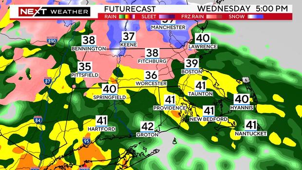
The rain makes significant advances in the afternoon, overspreading the area by the evening commute.
There will be some mixing with sleet, mainly northwest of Route 495.
Overnight, some colder air works in aloft, changing the sleet over to snow.
You can see that by dawn on Thursday it will be snowing in most areas north of the Massachusetts Turnpike while rain continues to the south.
The tricky part is attempting to determine how much impact this snow will have. Given that it is falling during the daylight hours, in April, onto fairly warm surfaces, it will struggle to accumulate.
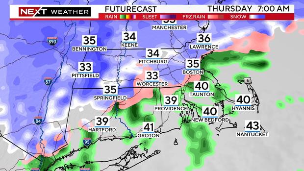
Temperatures will be above freezing, generally between 33-to-36 degrees in the snow area. Accumulation on roads will be toughest. We will see snow sticking on the grass before the roads and certainly in areas with elevation as well.
Really tough to lay this all out on a snow forecast map...There will be very stark differences over very short distances. Even within one town that has variable elevation (hills and valleys) there could be several inches of variability in accumulation.
How much snow in Massachusetts and NH?
We do not expect any accumulation in the Boston area or inside the Route 128 belt, although there may be some wet snow in the air from time to time.
Pretty much all rain over southeastern Massachusetts and all areas south of the Mass Pike as well.
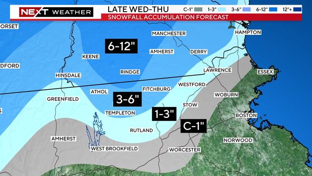
North and west of 128, through about 495, there should be some sticking to surfaces, perhaps enough for scattered coating up to an inch.
North and west of 495, including northern Middlesex and Essex counties, there may be as much as 1-to-3", again more so on grass than roads.
In the higher elevated areas of northern Worcester County and far northwestern Middlesex County, we are forecasting 3-to-6" of pasty, wet snow.
Some of the higher peaks extending into southwest New Hampshire could receive as much as 6-to-12 inches.
Power outages possible due to heavy snow
Given the heaviness of the snow, any accumulation on tree limbs will be dangerous. Combine this with the strong wind forecast, and we could very well be looking at numerous power outages in the higher snow areas.
The snow shield will push northward during Thursday afternoon as the center of the storm crosses southern New England. The snow may linger for several hours on Thursday afternoon and evening in northern Middlesex and Essex counties.
Unfortunately, the storm will be in no hurry to leave our area. We will be stuck in the clouds with off and on showers through Friday and Saturday.
This will be very low impact stuff, but a nuisance nonetheless.
Wind, coastal flooding
The winds will ramp up during the afternoon and evening Wednesday and be strongest overnight into Thursday morning.
We expect frequent easterly gusts between 30-to-50 mph across the entire region. Along the immediate coastline, the National Weather Service has issued a high wind watch for the potential of gusts as high as 60 mph.
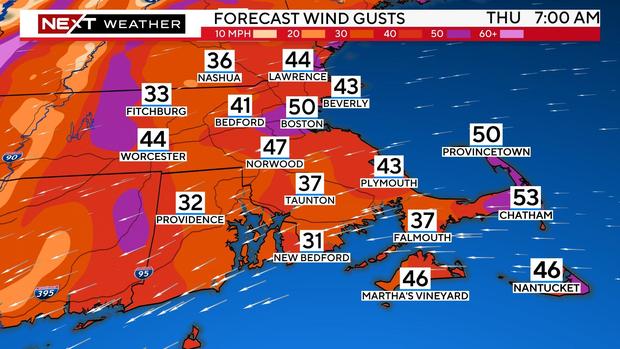
As the storm's center crosses over southern Massachusetts during the day Thursday, the winds will decrease significantly over southeastern Mass. but ramp up one final time over northeast Mass. and the New Hampshire and Maine coastlines.
We are particularly concerned about the area from Cape Ann to Salisbury to Hampton, NH, locations that have been battered time and time again the last several months.
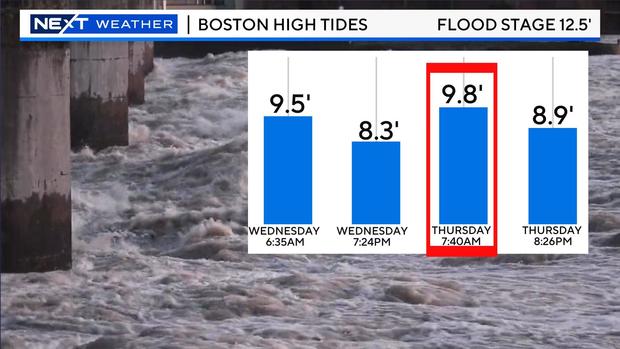
In these areas, there may be minor to moderate flooding along with another round of beach erosion.


