What is a bomb cyclone? Explaining the bombogenesis storm forecast
By Terry Eliasen, Meteorologist, WBZ-TV Exec. Weather Producer
BOSTON - "Bomb Cyclone."
Perhaps you have heard this term thrown around on the news over the last couple of days.
Sounds like a made-up term to get people in a frenzy and catch some national headlines. I will say I am torn on the use of it in a news or weathercast. The term "bomb cyclone" actually is a LEGIT phrase, but I am not sure there is value in blasting it over the airwaves. If it is followed by a valid scientific description of what that means and how it will impact you, I am good with it. However, it seems like more often it is used as a catch-phrase..."Bomb Cyclone to impact 50 million people"...
So what exactly is a bomb cyclone and is it the same as bombogenesis?
Low pressure areas are something you see just about every night on the local weathercast. Those "L's" floating across the map, typically with a few fronts attached. And I think most folks know that if an "L" is headed your way, some sort of stormy weather is coming. Simply put, storms form in response to a temperature contrast.
On a large scale, of course, there is a global contrast from the cold air at the poles to the warm air at the equator. Here in the mid-latitudes, we live in the "battle-zone," where airmasses of different temperatures and types tend to clash. A few times each year (on average) things come together just right, and the atmospheric setup becomes ripe for massive storm formation.
In the northeast, this typically happens in nor'easter season, between October and March. A storm approaches from the west or south and gets a jolt of energy from the Gulf Stream in the Atlantic to our east and BOOM. . . you get a highly impactful, coastal storm. Many of our most infamous storms, the blizzards etc., have formed this way.
Technically speaking, if the central pressure of a storm drops at least 24 millibars in 24 hours, you have bombogenesis, which is the formation of a bomb cyclone.
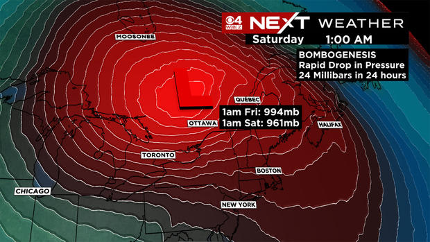
That is exactly what is happening in the upper Midwest over the next few days.
Take a look at the forecasted central pressure of the storm below. . .
7 p.m. Thursday: 1003mb
1 a.m. Friday: 994mb
7 a.m. Friday: 980mb
1 p.m. Friday 974mb
7 p.m. Friday: 966mb
1 a.m. Saturday: 960mb
Definitely a classic case of bombogenesis!
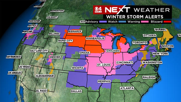
The difference this time, we are on the "warm side" of the storm. The blinding, blizzard-like conditions are happening in parts of the Upper Midwest and Great Lakes. For us, it will be a windswept, drenching rain. Certainly not the same level of impact you get from a blizzard, but 40-60 mph winds and 3 inches of rain is nothing to sneeze at, especially on one of the busiest travel days of the year.
My guess is, this won't be the last time we talk about bombogenesis this winter. . . and next time we could be digging out from a whole bunch of snow.


