Storm brings snow throughout Massachusetts overnight, with more expected Sunday
BOSTON - The WBZ Weather Team is continuing the NEXT Weather Alert for all of southern New England for the weekend nor'easter.
Here are the main headlines and changes Saturday:
- The timeline continues to be the heaviest snowfall overnight.
- While it will continue to snow during the day Sunday, it will mainly be light to moderate and, at times, struggle to accumulate along the South Shore and southeast coast where temperatures are near or above freezing and mixing with rain will occur.
- The highest snow totals will be located north and west of Boston in the Merrimack Valley and Worcester County.
- There will be a flash freeze Sunday afternoon and evening across eastern MA.
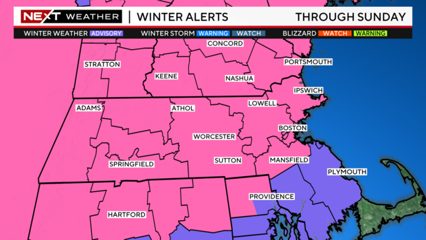
Winter Storm Warning
The National Weather Service has issued a Winter Storm Warning through Sunday for Essex, Middlesex, Worcester, Suffolk and Norfolk counties. A warning also is in place for all of southern New Hampshire. These are the areas that have the greatest risk of at least 6" of snow accumulation.
There is a Winter Weather Advisory out for Bristol and Plymouth County.
Snow arrives in Massachusetts?
The snow has arrived! It will continue to intensify from west to east Saturday night. The snow will immediately come down at a very good clip.
Snowfall rates were expected to top one inch per hour within the first few hours of arrival. The first several hours of the storm were when the majority of the snow accumulated.
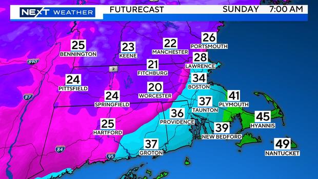
Between 7 a.m. and Noon, the rain/snow line will move northward through most of Bristol and Plymouth counties.
While it will still be snowing along and north of the Pike, the intensity will be much less, and the rate of snowfall accumulation will also decrease significantly.
As the center of the storm makes its closest approach to southern New England and then begins to pull away, it will throw one last burst of moderate to heavy snowfall across central and eastern MA. Some areas could pick up several additional inches Sunday afternoon and evening before the snow completely ends between 6-9pm.
As the center of the storm makes its closest approach to southern New England and then begins to pull away, it will throw one last burst of moderate to heavy snowfall across central and eastern MA.
Some areas could pick up several additional inches Sunday afternoon and evening before the snow completely ends between 6-9 p.m.
Snow/Precipitation Type:
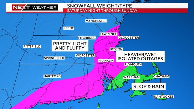
The farther inland you live, the lighter and fluffier the snow.
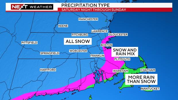
Closer to the coastline, (inside I-495) temperatures will be closer to, or slightly above 32 degrees and the snow will be much heavier/wetter. It may even mix with rain at times at the immediate shore. This is the region we are most concerned about getting some scattered power outages given the pasty snow and gusty wind.
Out over Cape Cod and the Islands, it will be mainly rain until the winds turn more northerly late in the storm on Sunday.
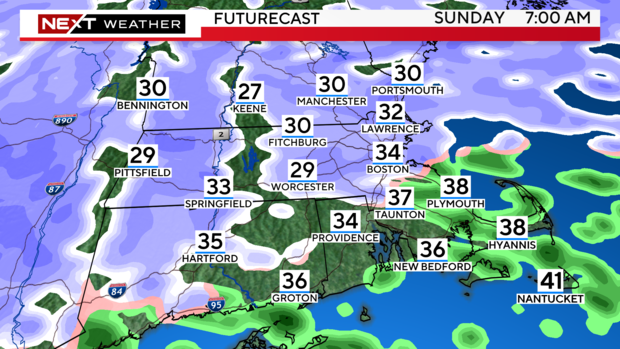
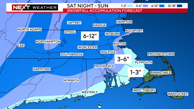
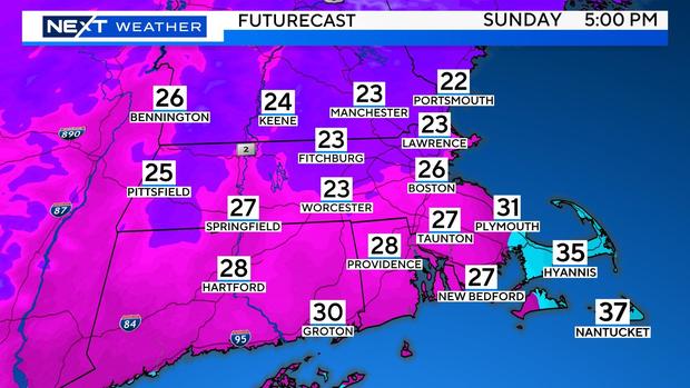
How much snow will Boston get?
Final snowfall amounts:
6-12" North and west of I95 and 128 including much of Essex, Middlesex and Worcester counties as well as southern New Hampshire.
3-6" - Tight area from Cape Ann to Boston and extending southward to inland (northern) Plymouth and Bristol counties.
1-3" - South Shore down through the South Coast and over to the Cape Cod Canal.
Very little (if any) for much of Cape Cod and the Islands.
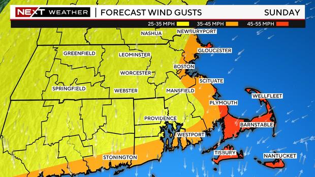
Winds:
The winds will not be a huge factor away from the coastline. Northeast gusts will peak between 35-45 mph right at the Shoreline and 45-55mph over Cape Cod and the Islands. Certainly not the strongest wind event we have had in recent weeks, but perhaps enough to cause some outages in the heavy/wet snow areas.
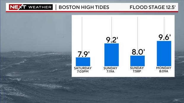
Are there coastal flooding concerns?
Tides are astronomically low this weekend. Therefore, the threat for any significant coastal flooding is low.
The times to watch would be the Sunday morning (7-8 a.m.) tide cycle along east-northeast facing beaches and the Sunday evening (7-8 p.m.) cycle in the more north-northeast facing beaches.
Flash Freeze:
Sunday's storm will also come with a flash freeze.
As the winds turn northerly in the afternoon and evening, sub-freezing air will be pulled down the coastline.
Temperatures will drop 5-10 degrees in a matter of minutes and, many areas that were in the mid to upper 30s, will quickly plunge into the 20s causing any untreated surfaces to ice up.
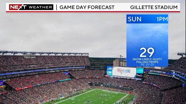
Patriots Game:
Of course, we cannot forget the Patriots are playing their final home game on Sunday afternoon at Gillette!
Light snow will be falling for parts of the game and temperatures will be dropping from the low 30s into the 20s.
Next Storm:
Lastly, unfortunately the stormy pattern will continue into next week.
Another strong storm will approach New England late Tuesday. This one may start briefly as a mix but then quickly change to a windswept rainstorm.
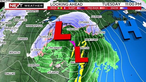
There may be several inches of rain Tuesday night into Wednesday, causing a rapid snowmelt and undoubtedly, a lot of flooding.
More on this to come...
As always, our WBZ Weather team will have you covered for the entire event on WBZ-TV, WBZ.com and CBS News Boston.


