Severe thunderstorm threat Monday afternoon, hail and isolated tornadoes possible
By Terry Eliasen, Meteorologist, WBZ-TV Exec. Weather Producer
BOSTON -- The WBZ-TV Weather team has issued a NEXT Weather Alert for the risk of severe thunderstorms Monday. After 6 consecutive days above 90 degrees, the longest heat wave in 6 years, we are set to end the streak with a bang, literally.
The atmosphere is primed for the formation of thunderstorms in our area. The National Weather Service has issued a Severe Thunderstorm Watch for all of southern New England until 8 p.m.
The parameters in place are only seen a handful of times each summer. Lots of available moisture and lift bring the potential for the development of rotating "supercell-type" storms. Yes, one of those days with the "tornado possible" designation.
The one limiting factor Monday will be the lack of sunshine. In order for clouds to build, you need rising air. This is caused, in part, from the sun heating the ground during the day time and that warmer air then rising rapidly (thus creating an unstable environment). Due to the storms coming in two waves today, there will be a good deal of cloudiness, limiting the amount of heating.
The first round of storms is expected through the early part of the afternoon. The severe threat is fairly limited though and most of the storms are expected to lose their punch as they move into eastern Massachusetts. The greater threat comes late Monday afternoon, into the evening hours. Assuming we get some sunshine after round one, the atmosphere will rapidly destabilize and we expect storms to fire up quickly in the mid-to-late afternoon.
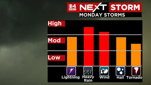
Any of the storms that form may contain torrential downpours, damaging winds, frequent lightning, hail and again, the potential for an isolated tornado. This is absolutely a day where you should stay tuned to updates, especially if you have outdoor plans Monday afternoon or evening.
Once the storms clear out Monday night, a rush of MUCH drier air moves in! Tuesday and Wednesday will be stellar summer days with low humidity and abundant sunshine.
There is another shower and storm threat Thursday into Friday, but so far, so good for the upcoming weekend, which looks dry and storm-free!


