Plowable snow storm likely for Massachusetts this weekend
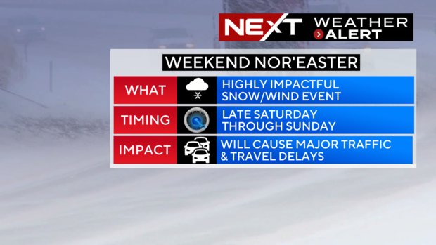
BOSTON - Gas up the snow blowers, dust off the shovels, the odds are increasing for a widespread, plowable snowfall this weekend across most of Massachusetts.
Because of this, the WBZ-TV Weather Team has issued a NEXT Weather Alert.
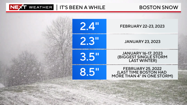
Does it feel like it's been a while? The last few winters have been SO lame. Is it possible that we have all gotten a bit rusty with regards to driving in, and dealing with, an actual snow storm?
The biggest storm last winter dropped a measly 3.5 inches of snow in Boston. Hah! Any true New Englander would laugh at numbers like these. It has been nearly two years since Boston and most of the suburbs had a storm with more than 6 inches, back on February 25, 2022.
It now appears it is time to pay our debts. Nothing is a lock just yet. Yes, there will be a storm and yes, we will see some impacts here late Saturday night into Sunday, but there remains some uncertainly with regards to the storm track.
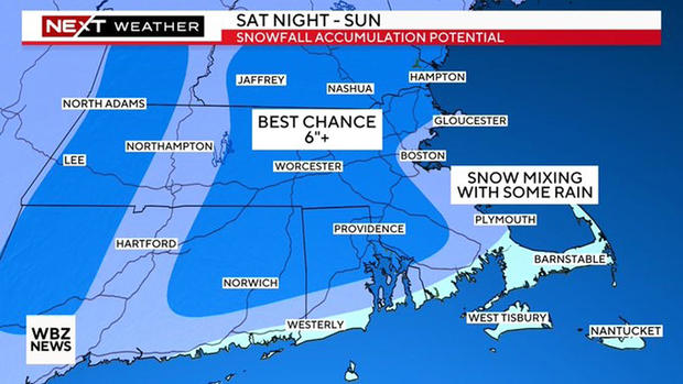
Therefore, if you are looking for a snow map and specific amounts for your town, we aren't quite there yet. Those finer details usually get ironed out about 48 hours ahead of a storm, in this case, sometime Thursday.
Here is what we can say, with confidence, as of this writing...
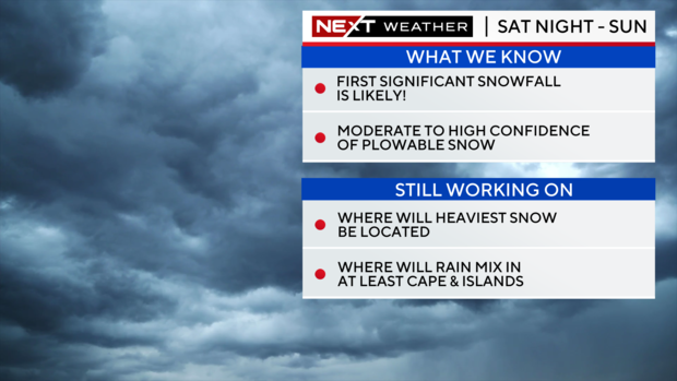
Confidence continues to increase for a widespread, plowable snow storm for much of our area.
All locations away from the immediate coastline (along and west of Interstate 95) have at least a 75% chance of receiving plowable snow.
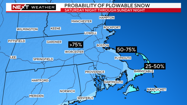
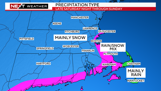
This will largely be all snow. Any mixing and rain will be confined to the immediate coastline and more so Cape Cod and the Islands.
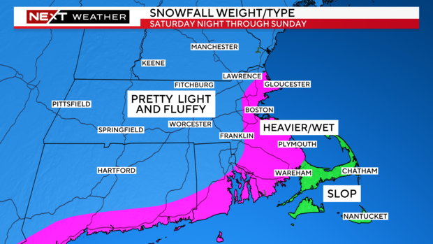
Given this, the weight of the snow will vary quite a bit depending upon where you are shoveling.
This does not appear to be a blockbuster storm. There will be a decent amount of snow and wind, but mainly at what I would call "manageable levels".
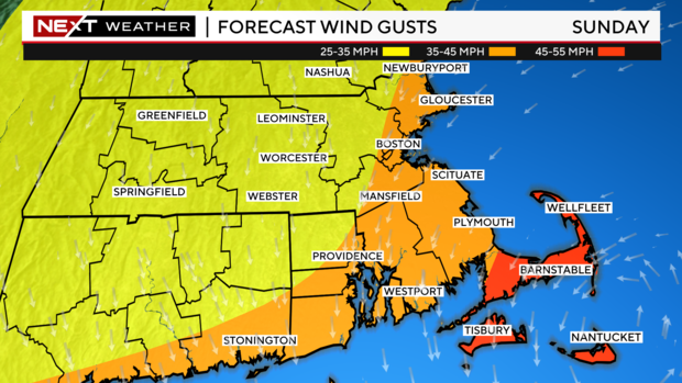
Peak wind gusts will be located at the coastline and particularly over Cape Cod and the Islands. Here, there could be gusts over 50 mph.
Elsewhere, farther inland, the winds will drop off significantly. We do not expect widespread power outages with this storm.
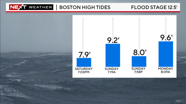
Some more good news - the tides are astronomically low this weekend. Therefore, the threat for any significant coastal flooding is low.
The time to watch would be the Sunday morning (7 to 8 a.m.) tide cycle.
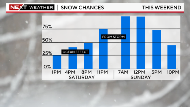
If you must go out, Saturday looks like the day to get stuff done. There will likely be some light, ocean-effect snow during the day, but the real snow shouldn't arrive until around midnight.
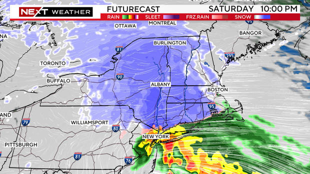
The heaviest snow will fall between about midnight and midday Sunday, slowly tapering off through the afternoon and evening.
Most of the accumulation will be done by 5 p.m. Sunday with just some light, scattered flurries thereafter.
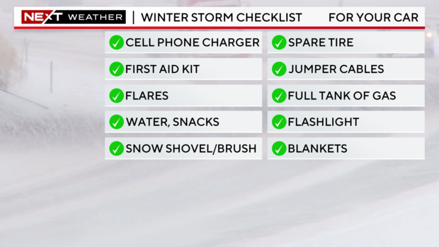
Finally, this seems like a good time for a safety reminder.
Always better to be prepared.
In your home:
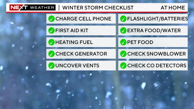
And in your car:
As always, our WBZ Weather team will have you covered for the entire event on WBZ-TV, WBZ.com and streaming on CBS News Boston.


