Maryland Weather: Tornado Watch For Parts Of Maryland Canceled
BALTIMORE (WJZ) -- Strong winds and severe weather are being reported in parts of Maryland Monday.
Severe storms hit parts of the state late Monday morning and into the early afternoon. The main threats are damaging winds, large hail and possibly tornadoes.
Almost all of Maryland is under a slight risk for severe weather; areas of extreme southern Maryland and into Virginia are under an enhanced risk.
A tornado watch formerly in effect for Anne Arundel, Baltimore, Calvert, Cecil, Charles, Harford, Howard, Montgomery, Prince George's and St. Mary's counties, as well as Baltimore City until 6 p.m. has been canceled for all but Cecil County.
There was a tornado warning for Baltimore and Howard counties and Baltimore city that expired at 12:30 p.m.
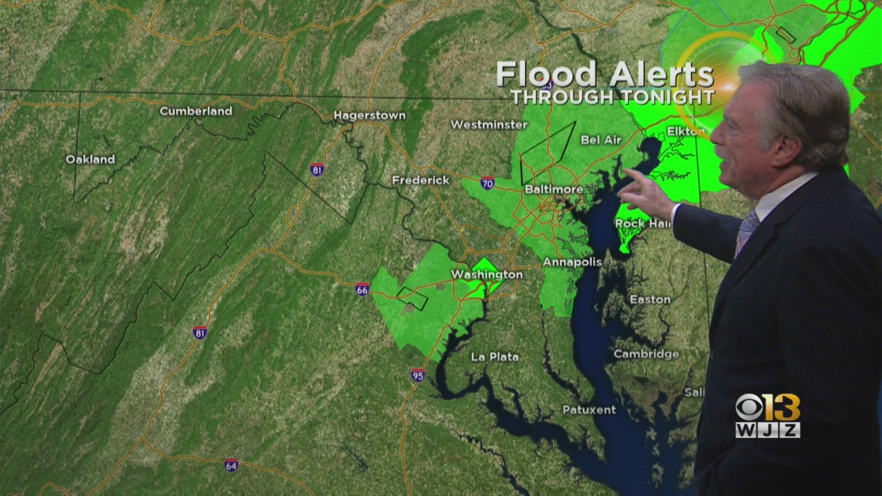
Maryland Weather: Flooding Expected In Low-Lying Areas
Isolated flooding is also possible; a coastal flood warning is in effect for Baltimore, Baltimore County and Harford County until 9 p.m. Anne Arundel County is under a coastal flood advisory until 10 p.m.
There are areal flood warnings in effect in Baltimore City, Anne Arundel County, Howard County and Baltimore County until 8 p.m.
Separate flood warnings are in effect for small streams in parts of Baltimore and Harford counties until 6:45 p.m.
People who park their cars near the waterfront in Baltimore should move them to higher ground, the city's Office of Emergency Management said Sunday evening. A parking garage at 501 South Eden Street will have free parking for area residents while the flooding risk lasts.
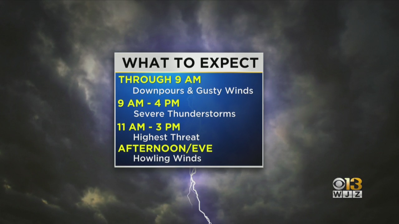
A storm system strengthened Sunday evening as it crossed through the Mississippi Valley and progressed toward the Eastern Seaboard. As this system moved into the mid-Atlantic, rain began falling overnight. The key timing for severe weather Monday is 9 a.m. to 4 p.m. -- the most severe was expected between late morning and early afternoon.
As this large system exits the region, strong winds will persist in its wake.
For this reason, wind advisories and high wind warnings have been posted across the state. Parts of central Maryland could see gusts up to 55 mph through 6 p.m. Monday. Areas under the high wind warning could see gusts up to 60 mph through Monday evening.
The National Weather Service has issued a wind advisory for the Baltimore and Washington, D.C. areas as well as Baltimore, Carroll, Charles, Frederick, Harford, Howard, Montgomery and Washington counties from 4 a.m. to 6 p.m. Monday.
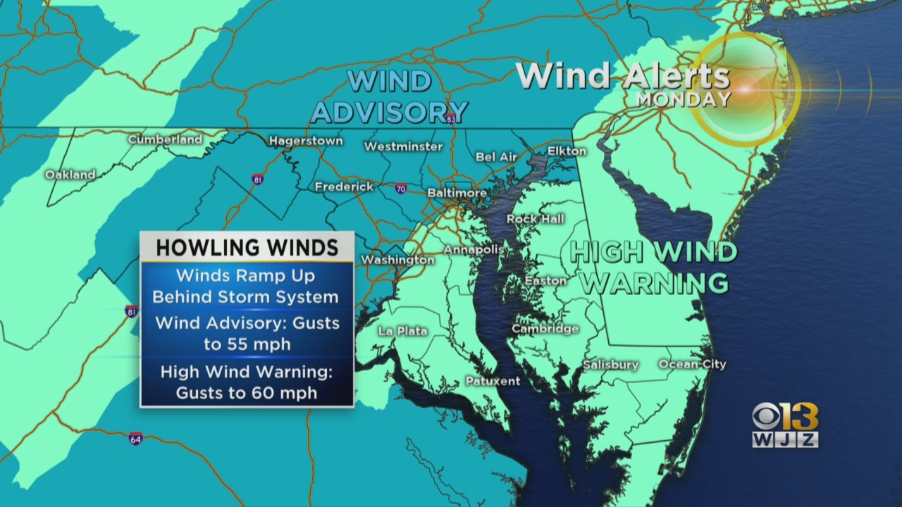 Elsewhere, high wind warnings are in effect Monday for Anne Arundel and Prince George's counties, far western Maryland and the Eastern Shore.
The strong winds could cause tree limbs to be blown down and a few power outages could occur.
The northern part of the Chesapeake Bay is under a gale warning, while the lower part of the bay and the mouth of the Potomac River are under a storm warning.
Baltimore's public works department is asking people to clear the storm drains near their home before the storms hit, if possible. They're also recommending people secure their trash cans and large items like outdoor furniture.
WJZ will bring you the latest weather updates on-air and online.
Stay up-to-date with the latest forecast by downloading the WJZ weather app.


