How much snow will Maryland see this weekend?


BALTIMORE -- We're still following the forecast for this weekend, as a significant storm system approaches the area.
Rain and snow will move into the area Saturday afternoon and continue through early Sunday morning.
*WINTER STORM WARNING* in effect for Carroll, Frederick, Washington, Allegany & Garrett counties and Northern Baltimore County from Saturday morning to Saturday evening.
*WINTER STORM WATCH* in effect for Carrol County and Northern Baltimore County.
Here's a breakdown on where precipitation is expected to hit by location, and how much each area can expect to see.
I-95 Corridor (Including Baltimore and Baltimore County)
Between one and two inches of snow are expected before changing to rain on Saturday evening. Areas farther from the Bay have higher chances of accumulation.
Baltimore County areas such Sparks, Monkton, and Upperco are likely to stay as snow longer than Essex or Catonsville, with possibly more than two inches of accumulation.
Frederick, Western Howard County, Carroll County, and Harford County, and northern Baltimore are expected to receive all snow, with accumulations between two and three inches.
Western Maryland
Areas including Washington County and westward can expect all snow, with totals between two and five inches, possibly higher in mountainous areas.
Our First Alert Weather Team will continue to monitor the data and make adjustments to the forecast.
Southern Maryland and lower Eastern Shore
Southern Maryland will not see snow accumulation, but could see up to an inch of rain.
Areas like the upper Eastern Shore, specifically Kent, and Queen Anne's Counties, could see a brief period of snow accumulation, not exceeding an inch, before changing to rain.
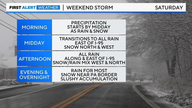
When will the storm hit?
Precipitation is expected to begin late Saturday morning or midday as a rain and snow mix.
Light rain and snow may linger into Sunday morning, but most accumulation will occur Saturday afternoon into Saturday night.
Will the storm impact my travel?
Temperatures will not be cold enough for significant issues on the roads, however snowfall rates, if they are heavy, will cause roads to become snow-covered quickly and create problems. This is most likely to occur Saturday afternoon and evening.
We'll be monitoring travel conditions in downtown Baltimore this weekend for those attending this weekend's Ravens game at M&T Bank Stadium.
Related Coverage:


